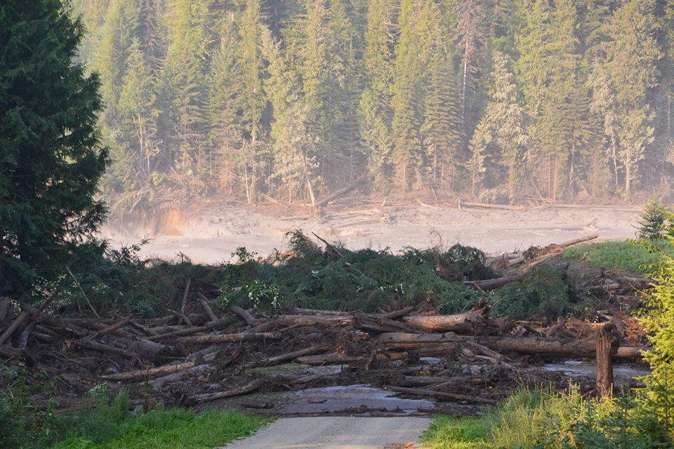
Silty water from the breached Mount Polley Mine dam floods a downstream creek and road Monday. | credit: Photo courtesy Cariboo Regional District Emergency Operations Centre
By: Ed Schoenfeld, Alaska Public Radio; Source: OPB
A dam break at a central British Columbia mine could threaten salmon fisheries in the Pacific Northwest.
Mount Polley is an open-pit copper and gold mine roughly 400 miles north of Seattle. A dam holding back water and silt leftover from the mining process broke Monday. It released enough material to fill more than 2,000 Olympic-sized swimming pools.
Government regulators have not yet determined its content. But documents show it could contain sulfur, arsenic and mercury.
Imperial Metals, the mine’s owner, issued a statement that only said the material was not acidic. Emergency officials told residents not to drink or bathe in water from affected rivers and lakes.
The spill area is in the watershed of the Fraser River, which empties into the Pacific Ocean at Vancouver, B.C. The river supports a large sport and commercial fishery in Washington state.
Brian Lynch of the Petersburg, Alaska, Vessel Owners Association says some of those fish also swim north.
“The United States has a harvest-sharing arrangement for Fraser sockeye and pink salmon through provisions of the Pacific Salmon Treaty. So any problem associated with salmon production on the Fraser will affect U.S. fishermen,” he says.
Imperial Metals did not respond to requests for comment. Its website says the mine is closed and damage is being assessed.
Provincial officials have ordered the corporation to stop water from flowing through the dam break. Imperial could face up to $1 million in fines.
Environmental groups in Canada and Alaska say Mount Polley’s dam is similar to those planned for a half-dozen mines in northwest British Columbia.
They say a dam break there would pollute salmon-producing rivers that flow through Alaska.
That could also affect U.S.-Canada Salmon Treaty allocations, including for waters off Washington state.
A big measles outbreak in British Columbia has crossed over the border into the American Northwest.
Health officers in B.C.’s Fraser Valley have confirmed over 350 cases of measles there since an outbreak started in early March. Six additional cases have now been diagnosed in Whatcom County, Wash., including a woman in her 20s who has prompted a regionwide alert.
While contagious, she mingled with crowds at a rock concert at Seattle’s Key Arena. She also visited Puget Sound tourist attractions such as the Pike Place Market, LeMay Car Museum and Harmon Brewing Company in Tacoma.
Whatcom County Health Officer Greg Stern says this measles outbreak traces back to a religious community in British Columbia’s “Bible Belt.”
“To the extent that people avoid vaccines, they increase both their risk and the risk of the community so that it can take hold. I’m worried about that.”
Already this year, seven cases of measles have been reported to the Washington State Department of Health. That compares to just five over the entire course of last year.
In recent years, the Washington and Oregon legislatures have made it harder to get vaccination exemptions for school-age children.
Dogwood Initiative executive director Will Horter said pipeline opposition is always stronger in polls when tanker routes and the possibility of oils spills are mentioned as part of the Northern Gateway project. Photograph by: JONATHAN HAYWARD , THE CANADIAN PRESS
Results not surprising in survey commissioned by environmental groups
Nearly two thirds of British Columbians are opposed to the $6.5-billion Northern Gateway pipeline and the tankers it will bring to the northern coast, according to a poll commissioned by environmental groups.
Conducted between Jan. 13-19, the Justason Market Intelligence poll of 600 people also found that 64 per cent (the same number that are opposed) believe the project will definitely or probably be built. The margin of error of the combined telephone and online poll is plus or minus four per cent.
The survey showed that 92 per cent were aware of the project, which will carry diluted bitumen from the Alberta oilsands to Kitimat for transport by tanker overseas to open up Asian markets.
The poll was commissioned by the Dogwood Initiative, ForestEthics Advocacy, Northwest Institute for Bioregional Research and West Coast Environmental Law.
The Enbridge pipeline project received approval last month from a joint panel federal review of the National Energy Board and the Canadian Environmental Assessment Agency.
Several First Nations and environmental groups have already launched court action against the panel decision.
Prime Minister Stephen Harper’s Conservative government has until the middle of this year to grant approval.
The findings showed that four times as many of those surveyed “strongly” oppose the project (50 per cent) than who “strongly” support the project (12 per cent). Another 17 per cent somewhat support the project.
The majority-opposition finding is not an unusual for a poll commissioned by environmental groups, which generally highlight in their questions the introduction of super tankers and the possibility of oil spills.
Dogwood Initiative executive director Will Horter said opposition is always stronger in polls when tankers are mentioned as part of the Northern Gateway project.
“People have very strong concerns about oil pipelines, but have deep, deep concerns about the oil tankers,” said Horter.
Business and industry-commissioned polls, which tend to highlight the economic benefits of Northern Gateway, usually find higher support for the project.
A B.C. Chamber of Commerce-commissioned poll released in December found nearly 50 per cent support for Northern Gateway.
The Justason poll also found that 51 per cent distrust the joint review panel process, while 32 per cent trusted it.
If Premier Christy Clark’s five conditions for supporting heavy oil being transported through B.C. are met, 49 per cent said they would be a lot or a little bit more supportive of the project.
The B.C. Chamber poll had found that should the project meet the five conditions, support increased to 63 per cent.
Clark’s conditions include the passing of an environmental review, creating world-leading marine and land spill prevention and recovery systems, addressing First Nations’ rights and receiving a fair share of economic benefits.
The ocean grew choppy and storm clouds darkened the southern sky as we paddled the final miles toward an abandoned Haida village site at the heart of a wedge-shaped archipelago 175 miles in length, 70 miles off the northwest coast of British Columbia. Until recently, this remote chain of islands was known as the Queen Charlotte Islands, but three years ago, the Haida Nation returned that colonial name to the provincial government, in a ceremony using the same style of bentwood box that once housed the remains of the dead. The place is now Haida Gwaii (pronounced HI-duh GWY) — Islands of the People — both officially and, unquestionably, in spirit.
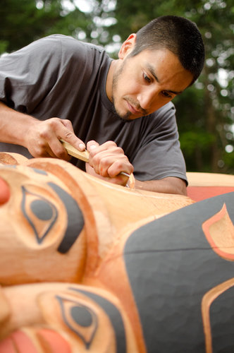
Bruce Kirkby for The New York Times Carving the Legacy Pole.
The hillsides soaring above our kayaks, scraped bare by clearcutting three decades earlier, were an emerald-hued crew cut, a fuzz of young alder and spruce interspersed with occasional landslides. On a distant ridge beyond stood the silhouettes of giants, stark evidence of where logging had ground to a halt.
There is an even older Haida name for this archipelago, which roughly translates to “Islands Emerging From (Supernatural) Concealment.” It is an apt moniker. On these craggy islets — perched on the edge of the continental shelf and pressed against the howling eternity of the Pacific — life exists on such a ferociously lavish scale that myth and dreams routinely mingle with reality.
For three days, Dave Quinn and I — neighbors, friends and longtime sea kayak guides — had rejoiced amid a world of windswept islets, breaching humpbacks, raucous seabirds, natural hot springs and solitude. While it was glorious to return to waters we knew so well, there was a deeper purpose to our journey: Paddling from dawn until dusk and then some, we’d been racing north toward Windy Bay.
Even as our kayaks crunched aground on its white shell beach, elsewhere bags were being packed, boats readied, float planes fueled. Two great war canoes — long and colorful — were plowing southward from the traditional Haida strongholds of Old Massett and Skidegate, crammed with youth. The next morning, we would all converge here, to witness the raising of a monumental pole (a term preferred by First Nation groups over “totem”) in the southern archipelago, the first such event in over 130 years, since smallpox decimated the local population and left every village unoccupied. That fishermen, loggers, police and government officials would join alongside the Haida Nation in celebration, after decades of bitter land-use conflict, marked a once unimaginable reconciliation — and a way forward extending far beyond these remote shores.
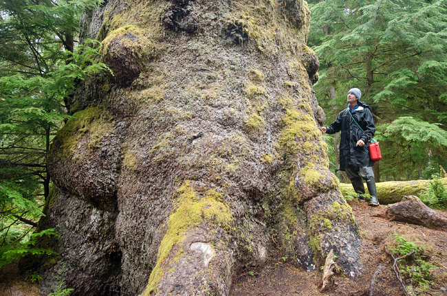
After setting up our tent and brewing cowboy coffee, we set off on foot toward the village site — Hlk’yaah in Haida — tucked in an adjacent cove. Just a few steps into the forest, we paused in awe. Arrow-straight trunks, the girth of minivans, rose like cathedral columns from a thick blanket of moss cloaking the forest floor. Drenched with an average of 250 days of rain annually, the conifers of Haida Gwaii — red cedar, Sitka spruce, western hemlock — attain storybook proportions. According to the West Coast writer John Valliant, “These forests support more living tissue — by weight — than any other ecosystem, including the equatorial jungle.”
Bruce Kirkby for The New York Times Eagle down on the pole.
Forty years earlier, a logging company applied to move its clearcutting operations from northern Haida Gwaii — at that time ravaged by industrial-style logging — to this very soil. As John Broadhead, a local conservationist, wrote: “The company couldn’t have been leaving behind an area of more ecological devastation, or moving to one more pristine.” Having witnessed the frontier’s rapacious appetite drive sea otter and whale populations to the brink, the Haida voiced immediate opposition, but it seemed unimaginable that anyone might deflect the logging juggernaut.
The ’70s and ’80s were a time of excess and frenzy on this coast, when tens of thousands of dollars’ worth of salmon could be hauled from a single net, and the hewing of trees worth $20,000 each was not uncommon. While the Haida engaged in a decade of fruitless committee meetings, negotiations and court cases, clearcutting crept relentlessly southward.
By 1985, the small nation was fed up. Establishing a remote camp on Lyell Island, they settled in for the long haul, standing arm in arm, blockading a logging road and day after day turning back furious loggers who in many cases were neighbors, and even friends. Beyond lay Windy Bay, and some of the last remaining stands of “Avatar”-scale old growth on the coast. Tensions skyrocketed, and soon national news outlets descended.
Eight months later a showdown took place and as police officers moved in, a young Haida Royal Canadian Mounted Police officer was forced to arrest his own elders. Over the next two weeks, 72 protesters were shackled and led away. But the images that emerged changed the mood of a nation, and led to an unprecedented agreement between the Haida Nation and the government of Canada. Agreeing to manage cooperatively what, in 1993, would become Gwaii Haanas National Park Reserve, they created an accord now emulated around the world. And while roots of the Haida revival can be traced back to the ’60s — when the lost arts of canoe building, mask making and pole carving began to re-emerge — it was the blockade and the resulting co-management of traditional territory that changed everything.
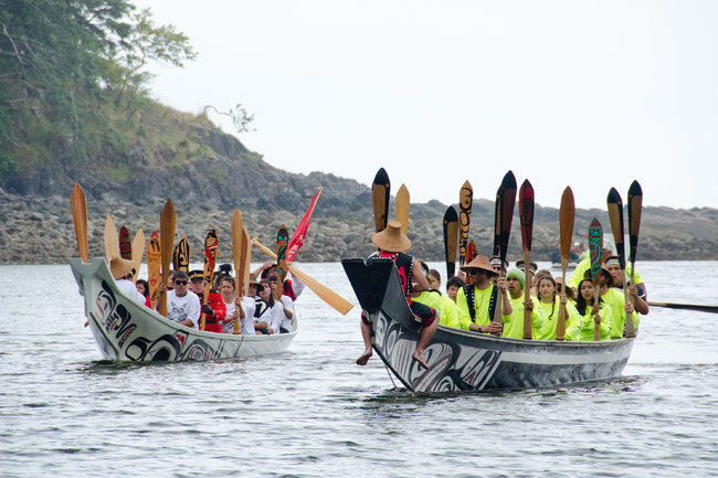
Bruce Kirkby for The New York Times Traditional Haida canoes arrive for the ceremony.
Dave and I arrived at the once-abandoned village site to find a hive of activity: electrical generators, an excavator and steaming vats of seafood chowder. At the center of everyone’s attention — though still horizontal — the 40-foot Legacy Pole, celebrating the 20th anniversary of moving from conflict to reconciliation with the establishment of the park. Lying beside a recently constructed longhouse, and surrounded by carvers, its 17 deeply incised figures, all based on the traditional Haida ovoid form, sprang from luxuriant cinnamon-colored cedar.
Although the raising was just 24 hours away, plenty of work remained to be done. Penciled design lines were shaved away, even as traditional black and red paints were applied. (The red, interestingly, was “Navajo” from Benjamin Moore.) Jaalen Edenshaw, the lead carver, quietly shaped a raven’s eyes as he told us of selecting a living tree from the forests. Alongside two apprentices, he had shaped the pole for an entire year. Among the many modern stories depicted in his design was the blockade, symbolized by five protesters with interlocked arms. With an eagle at the peak and a sculpin fish at the foot, the pole also tells of Gwaii Haanas becoming the first area on the planet to be protected from mountaintop to ocean floor when a National Marine Conservation Area was added to surrounding waters in 2010.
Amid the crowd was Guujaaw (pronounced GOO-jow), Mr. Edenshaw’s father and the widely recognized former president of the Haida Nation, who had stared down decades of negotiators and became emblematic of the Haida’s dignified, nonviolent resistance.
Suddenly, above the hubbub, came a cry: “Guuj! How about a birthday song?” The war canoes had arrived, and one of the young paddlers was celebrating a birthday. Guujaaw raised a skin drum, its rhythmic beat echoing through the forest like a heart. As he launched into a forceful chant — “Hey hi yo, ha wee ah” — everyone joined in. The young birthday boy rushed forward, dancing a traditional Haida stomp, knees deeply bent, arms in the air. Then, as quickly as it began, the song ended, and the carvers returned to their work.
Bruce Kirkby for The New York Times Dave Quinn stands beside a giant tree near the Windy Bay village site.
The next morning we woke from our tent to find an immense Coast Guard cutter anchored offshore, surrounded by an armada of smaller fishing vessels. Zodiacs began shuttling dignitaries, elders, children and curious visitors ashore. By noon, more than 400 people had gathered — unquestionably the most to stand on these shores since the village was abandoned 150 years previously.
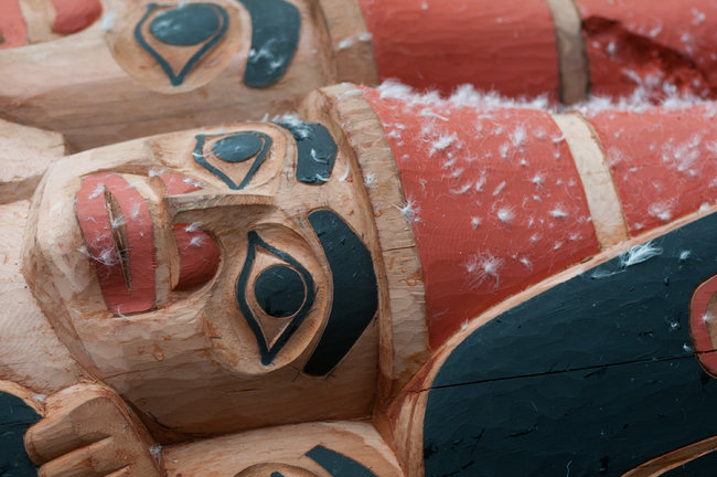
By early afternoon the skies had cleared. Chiefs gathered in ceremonial headdresses adorned with ermine skins and sea lion whiskers. Blessings were given, speeches made. A bare-chested man in a nightmarish mask danced to clear away malevolent spirits, and afterward, a matriarch splashed water over the pole, purifying it. Children followed, tossing handfuls of fluffy eagle down that floated on a soft breeze.
Six immense ropes — two inches in diameter — had been lashed to the top of the pole, and at last the assembled crowd was directed to find places on each. Weighing 7,000 pounds, the pole was relatively light, but a weathered Haida fisherman explained that any pole raising can be dangerous. The countdown began. Boots bit into mud, backs heaved, and the great pole floated skyward. In a blink it was up. A few more hoarsely shouted instructions — “Pull on the yellow rope! Ease off on blue” — and it stood vertical. Cheers erupted. Boulders were rolled into the deep hole at its base, pounded in place with long wooden beams. Shovel after shovel of gravel followed.
Two days later, Parks Canada and the Haida Nation hosted a potlatch, or celebratory feast, and in Haida tradition, every person on the islands was invited. The Canadian government outlawed potlatching from 1884 to 1951, making the event a poignant symbol of progress. In a community hall packed to the rafters, I found myself sitting near Allan Wilson, a hereditary chief from Old Massett and the junior Mountie officer forced to arrest his own elders at the blockade, decades ago. He is a squat, powerful man, and his crew cut was peppered with white. A tangle of necklaces hung from his neck. “To this day I remember every step I took,” he said. “My legs felt like they weighed 300 pounds each.” He paused, then laughed. “I was happy it was raining, so no one could see my tears.”
I asked about the pole. “It feels as if we’ve had a big pot here on Haida Gwaii with a hole in it,” he said. “Now that missing piece has been put back in. The leak has been plugged. And all our stories, from before and those still to come, can stay in there.”
Later, 14 elders who stood on the line were introduced. As drums beat and dancers danced, Miles Richardson — who led the resistance during the blockade — uttered once again the words heard on newscasts across Canada: “We are here to uphold the decision of people of the Haida Nation. There will be no logging in Gwaii Haanas anymore.” The deafening applause was that of a nation whose history now lies newly ahead.
The Huffington Post | By David Moye Posted: 07/30/2013
The two videos came to light after a Canadian app company called Play Mobility put out a request for videos of Bigfoot, the Loch Ness monster and its Canadian cousin, Ogopogo, on behalf of itsLegend Tracker app, which drops legendary creatures such as Sasquatch and the Loch Ness monster into real settings.
The first video was posted to YouTube on July 18 and appears to show a group of Chinese tourists in Mission, British Columbia, taking photos of a large ape-like figure in the forest.
It’s hard to make out what the creature is, but one tourist helpfully provides a hint by grunting “Sasquatch,” the same way Japanese actors shout “Godzilla!” in the movies.
The other video, posted July 24, shows the distant image of what could be another ape-like creature ambling in a forest, just a little too far away to be seen clearly.
The videos, while compelling, are raising skepticism since the Legend Tracker app allows people to fake their own Sasquatch and Nessie pics.
Blogger Brian Abrams thinks the video footage stinks more than a non-bathing Bigfoot.
To be fair, the Pacific Northwest is a hotbed for Sasquatch sightings. Legend Tracker spokesman Miles Marziani insists the company had nothing to do with the allegedly user-submitted videos.
He claims the company is trying to pinpoint the exact location of the July 24 sighting.
Crowd-sourced cryptozoological expeditions have their charms, but that may not be the most effective way of proving the existence of Bigfoot, according to Idaho State University professor Jeffrey Meldrum, author of “Sasquatch: Legend Meets Science.”
Trains would feed growing, but much smaller, terminals in B.C.
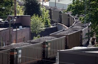
Jennifer Buchanan / The Herald A coal train passes through Everett in May. Proposed export terminals would increase the number of trains between Seattle and Bellingham.
Bill Sheets, The Daily Herald
If coal export terminals proposed for the Pacific Northwest are never built, the number of trains rumbling through Washington state filled with coal would still increase.
Coal is already shipped from British Columbia, and terminals there are expanding.
Based on projected numbers, however, those increases would not come close to equaling the combined capacity of the terminals proposed for Cherry Point near Bellingham and two others in the Northwest.
Opponents of building coal export terminals in Washington say they would bring traffic congestion from the number of trains, and generate coal dust and greenhouse gases.
Supporters say Cherry Point will create jobs — 4,400 temporary, construction-related jobs and 1,200 long-term positions, according to SSA Marine, the Seattle company that wants it built.
If Washington says no to the terminal, coal trains will still come through Western Washington, but the jobs will go north to Canada, SSA Marine spokesman Craig Cole said.
“We do know there’s demand (for coal in Asia) and port operators will seek to service that demand, whether they’re in the United States or British Columbia,” he said.
The proposed $650 million Gateway Pacific terminal at Cherry Point would add an average of 18 trips per day — nine full trains going north and nine empty trains traveling southbound — between Seattle and Bellingham. Marysville, which has 16 street crossings, and Edmonds, with a crossing at the ferry dock, would be the communities most affected in Snohomish County.
On average, about four coal trains per day pass through Snohomish County on their way to Canada, according to BNSF Railway.
The Cherry Point terminal could ship an estimated 60 million tons per year of coal, grain, potash and scrap wood for biofuels to Asia. Coal would make up the bulk of the shipments, according to the state Department of Ecology, which is handling the environmental review for the project. That review is expected to take at least a couple more years.
The Millennium terminal proposed for Longview, Wash., would have a coal capacity of about 48 million tons, according to the ecology department. Trains to this port would travel across the state but not north to Seattle and beyond.
Together, these ports could ship 117 million tons per year.
Possible expansions at the five ports in British Columbia could add 55 million tons per year to their current capacity, according to numbers compiled by SSA Marine.
If all of the B.C. expansions come to pass, they would roughly equal the output of Gateway Pacific.
“There will be additional coal that will be going to British Columbia, and we will be working hard to increase the percentage,” said Jim Orchard, senior vice president of marketing and government affairs for Cloud Peak Energy, a coal-mining company based in Denver.
At the same time, it won’t equal what could be shipped through the U.S. terminals, he said.
Cloud Peak operates two mines in Wyoming and one in southeastern Montana, in the area known as the Powder River Basin, Orchard said.
The greater the shipping capacity, the faster the coal can be mined without piling up, he said.
Without the U.S. terminals, “the timing with which we get to new reserves, it just would take longer,” Orchard said.
The largest potential British Columbia terminal expansion could occur at Ridley Terminals in Prince Rupert, B.C., 460 miles north of Vancouver by air.
This port gets ships to northern Asian ports one day faster than those sailing from Vancouver and three days faster than ships leaving from Long Beach, Calif., according to the Ridley website.
Right now, Ridley handles about 12 million tons per year. It has plans to double to 24 million tons, but has access to a vacant area nearby that could allow it to grow by 36 million tons or more on top of its current capacity, according to numbers compiled by SSA Marine.
It could potentially grow by even more than that.
Adjacent to Ridley’s current terminal is a 110-acre wooded tract called “Area A” that could be used by the terminal for further expansion, according to quotes from Ridley president George Dorsey in Coal Age magazine in March 2012.
“All that’s needed are the capital investments necessary,” Ridley said in the story. “Area A gives us the capacity to double the facility, from 24 (million tons) to 50 (million tons) and beyond. There’s so much space, it’s infinitely expandable.”
A Ridley official could not be reached for further comment.
“B.C. terminal operators are very competitive and capable and, like most businesses, will creatively endeavor to find a way to meet needs,” said SSA Marine’s Cole.
Still, Prince Rupert’s distance from the U.S. mines would increase travel costs, said Dennis Horgan, vice president and general manager of the Westshore Terminal in Tsawwassen.
“It’s a long way up there,” he said.
Currently, BNSF trains carrying coal through Washington end their run at Tsawwassen, said Courtney Wallace, a spokeswoman for the railroad.
Westshore is increasing its capacity by 4 million tons per year, to 33 million, and will be maxed out, Horgan said.
Some trains do pass over the Canadian Rockies carrying coal from Wyoming mines to Prince Rupert, according to Horgan.
“It’s still a long way,” he said.
Most of the coal shipped from Prince Rupert comes from British Columbia, Horgan said.
Westshore and Ridley ship only coal, he said. Neptune Terminal and Fraser Surrey Docks in Vancouver handle a mix, and Pacific Coast Terminals, based in Port Moody, ships mostly sulfur but has plans to add coal, according to Horgan. These terminals put together are much smaller than the Tsawwassen and Prince Rupert facilities.
Other commodities could figure into the picture, Wallace of BNSF Railway said.
“It is important to keep in mind that freight rail traffic will increase with or without coal export,” she said in an email. “Train volumes through any community ebb and flow based on several factors: market demand, customer needs, economic conditions, etc.
“Washington state’s economy is built on trade and ports and demand is increasing domestically for all goods as the population grows,” she said. “That’s a good thing, especially for a state like Washington that is heavily dependent on trade.”