OSO — The damaged stretch of Highway 530 closed since the deadly March mudslide will reopen to traffic this weekend, state transportation officials said Thursday.
Exactly when it will open is to be announced today by the state Department of Transportation, whose leaders had predicted it would be mid-June before enough slide debris could be removed to enable safe travel by drivers.
When it reopens, the road will be a single lane and a pilot car will lead vehicles in each direction, as is done now on the parallel Seattle City Light access road that has served as a temporary route for the past month.
The March 22 mudslide killed 42 people and entombed a mile-long stretch of the highway under more than 100,000 cubic yards of debris. One person, Kris Regelbrugge, is still missing.
IMCO Construction of Ferndale received a $4.9 million contract to clear the debris in preparation for another contractor to repair and reconstruct damaged sections. The state might award a contract for that work as early as today.
In recent days, as IMCO workers removed more and more material, state transportation officials got a better sense of the extent of damage.
Most of the original road is intact, with slightly more than 500 feet actually missing, said WSDOT spokesman Travis Phelps on Thursday. That section will be lined with gravel and rock when the single-lane road is reopened, he said.
The state isn’t expected to restrict who can use the one-lane road.
Meanwhile, residents and community leaders plan to gather along the closed road Saturday morning for a moment of silence. Then they, with Gov. Jay Inslee and Transportation Secretary Lynn Peterson, will walk the road.
This will be one of the final events before cars and trucks are allowed to drive by the Steelhead Haven neighborhood wiped out in the disaster.
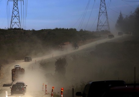
Mark Mulligan / The Herald Vehicles kick up dust as they travel eastbound on the service road bypass of Highway 530 toward Darrington Tuesday afternoon. Photo taken 20140429
OSO — The single-lane access road that bypasses the debris field of the Oso mudslide opened Tuesday morning.
It didn’t take long for grateful commuters to line up. State Department of Transportation spokesman Travis Phelps said as many as 60 vehicles at a time queued up to make the trip past the slide zone on the first day.
The access road off Highway 530 is accessible around the clock to local traffic, providing a much-needed lifeline to Darrington.
All trips are escorted through with a pilot car, leaving eastbound at the bottom of the hour and westbound at the top of the hour.
In many ways, it’s like a ferry line for passage to a remote island, with cars queueing up and neighbors getting out to chat to await the signal for the convoy to move forward.
Naomi Lieurance had gone to an appointment in Mount Vernon Tuesday morning with her shi tzu, Harley, via the Highway 20 route.
She had heard about the road opening during the day and was now waiting in line in Oso to return home to Darrington, hoping the new route will improve her access to the rest of the county.
“It’s got to be better than the Mountain Loop Highway,” she said.
She chatted in line with fellow Darrington resident Jake Sowers, who came over the access road earlier in the morning with his wife and was now heading home.
“I didn’t think it was as bad as I thought it was,” Sowers said. Approximately two dozen vehicles, including several logging trucks, made the 1:30 p.m. trip past the slide area to Darrington.
The view along the two-mile access road is not for the faint of heart, however.
The route skirts the edges of the slide zone. Trackhoes and construction vehicles below are dwarfed by a surrounding sea of rolling hillocks of mud and giant piles of broken timber. An American flag hangs from halfway up a denuded tree trunk.
The convoy passes stands of birch trees with new leaves and a pile of mangled cars. Behind it all is the exposed slope of the 650-foot cliff that slammed down into the valley on March 22.
“The horrific magnitude of it doesn’t sink in until you’ve seen it,” said Sowers, who laid eyes on the slide for the first time Tuesday morning.
A former ship’s mate, Sowers said, “I’ve seen some sad things in my life. I once surveyed a sunken ship, and this is right up there with it.”
The unpaved route is steep in places, with the convoy kicking up dust as it creeps over the hills.
According to the transportation department, only local traffic will be able to use the access road, and logging trucks will be able to use the road between 5 a.m. and 5 p.m.
No vehicles pulling trailers are permitted. The speed limit is a constant 10 miles per hour, and no stopping is permitted along the two-mile route.
The pilot cars and security at the two ends of the road are staffed by contractors hired by the state. Granite Construction Co. of Everett has been awarded a $3.4 million contract to maintain the access road and drive the pilot cars. Another firm, Seattle-based Central Protection, is providing security services.
The route is expected to remain open until at least one lane of Highway 530 is reopened. When that will happen is not immediately known, Phelps said.
For someone who wants to drive from Darrington to Everett, each of the two available options takes about two hours.
One of them, however, is probably a lot easier on the car. There also are places to eat, talk on the phone and go to the bathroom.
Since the disastrous March 22 landslide that blocked Highway 530 east of Oso, most drivers have been using Highway 20 to get from Darrington to the I-5 corridor. This is the route recommended by the state Department of Transportation.
Four days after the slide, to create another option for drivers, the Mountain Loop Highway from Granite Falls to Darrington was opened for the season. The road is administered by Snohomish County.
Part of the Mountain Loop stretch was built on the former right-of-way of the Everett and Monte Cristo Railway, built in 1892 to haul gold copper, lead, and iron ores to smelters in Everett, according to HistoryLink.org. The tracks of the railroad were removed in 1932.
One section of the Mountain Loop Highway is a 14-mile, one-lane, gravel logging road. This stretch receives heavy snow and is closed every winter. The road was entirely shut down for four years, from 2003 to 2007, after it washed out in several places during a storm.
After the Oso slide, the state supplied snowblowers to open the road early for the year, county officials said.
The drive of 54 miles from Darrington to Granite Falls takes an hour and 40 minutes, according to the state. Add 20-plus minutes to Everett and it’s a little over two hours.
“Four-wheel drive or high-clearance vehicles are strongly recommended,” according to a description of the road on a U.S. Forest Service website. It has a 5-ton weight limit and is considered unsuitable for commercial trucks or freight.
Don Beavon, of Tulalip, drove the Mountain Loop Highway in his 1992 Honda Civic the day it opened. He said he made it from downtown Marysville to Darrington in an hour and 45 minutes.
He used quote marks around the word “highway” in an email about his experience.
“It was very muddy with potholes and temporary 25-mile per hour speed limit signs posted all along the way,” Beavon wrote. “I bottomed out a couple of times but numerous double-long dump trucks full of gravel were heading in to make improvements, as was a heavy-duty roller.”
The smoother route takes drivers from Darrington north to Rockport on Highway 530, west to Burlington on Highway 20 and south to Everett via I-5.
This route is 94 miles, compared to 70 from Darrington to Everett via Mountain Loop, but drivers can cover the distance in roughly the same amount of time. There are no gas stations or other services on the Mountain Loop, according to the state.
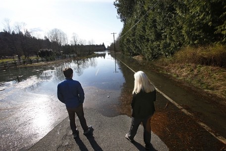
Genna Martin / The Herald Patricia Flajole (right) and son Pat look out over a flooded Highway 530 east of the Oso mudslide area on March 23, the day after the slide. The Flajole family owns a cabin just east of the slide area. The water, which had backed up because of river blockage, has mostly receded since then.
By Bill Sheets, Chris Winters, Jerry Cornfield and Rikki King, The Herald
Nearly three weeks after the devastating landslide in Oso, discussion of the fate of Highway 530 is beginning in earnest.
A series of community meetings has been scheduled for next week to gather input and discuss options for the daunting task of rebuilding the 1-mile stretch of highway that was smothered by the March 22 mudslide.
The section has been closed to the public since then, severing Darrington’s direct lifeline to Arlington and the I-5 corridor.
State and Snohomish County officials have been discussing with families of victims the delicate matter of digging out the highway while more people and belongings likely are still buried in the mud.
To date, 36 victims of the mudslide have been confirmed dead, with county officials releasing the names of three more victims Thursday.
Eight people are still missing.
“It’s kind of sacred ground for them and we want to make sure we’re going in there in the most respectful way possible,” said Travis Phelps, a spokesman for the state Department of Transportation.
In the meantime, officials are also beginning to look at the longer-term economic effect of the slide. Residents are deeply concerned about the effects on Darrington’s economy and culture if the town remains cut off for months.
“Of course we need that road open. That’s our lifeline to the outside world,” said Kevin Ashe, a part-owner of the Darrington IGA.
The only other major route into town is on Highway 20 through Skagit County, which turns a 45-minute drive to Everett into a two-hour detour.
Crews so far have removed most of the mud from a few hundred feet of Highway 530 on the western edge of the slide area.
“We’ve made some progress but not a heck of a lot,” Phelps said.
Because much of the highway is still buried, it’s too early to tell whether the road will be salvageable, he said.
“I’m sure some of it’s been damaged and some of it’s not,” Phelps said.
On the east side, part of the highway is still under water where the North Fork Stillaguamish River pooled up behind the slide. Even if the road can be repaired, the river’s ultimate course through the altered landscape will play a large part in determining if the road can remain in its current location, Phelps said.
If the road has to be rebuilt, topography of the surrounding area will be a factor, he said. Some steep hills are located south of the current highway right-of-way.
Engineers have begun studying possible routes, he said. When these become more developed, they’ll be shared with the public at later meetings.
“We’ve started looking at the terrain,” Phelps said.
Because of all these factors, it’s impossible to estimate when the highway could reopen or how much it might cost, he said.
The economic damage isn’t limited to just the highway. Damage to houses and other properties that were destroyed in the slide area is estimated at $6.77 million, according to a county assessor’s report released Thursday. About $919,000 of that was from the flooding.
More than 34 houses were destroyed and at least 10 manufactured homes, in addition to vacant lots, camping sites and other kinds of buildings, according to the report.
Because of the extent of the slide and the flooding, some areas have not been assessed yet, especially east of the slide near where a berm is being built.
While the federal government likely will reimburse the costs of rebuilding Highway 530, the longer-term recovery period is likely to come out of local pockets.
The economic hit to Darrington could be serious due to the reduced access and increased costs of getting to the town.
One worry, for example, is at what point people who commute into Darrington for jobs, or those who commute from Darrington to Arlington or the rest of the county, will decide the hassle of the commute isn’t worth the job.
In looking toward the longer term, the Puget Sound Regional Council has recommended that $5 million in federal funding be used to support economic recovery in Darrington.
The PSRC, an intergovernmental body that distributes about $240 million in federal transportation funding annually, will perform an unusual workaround to free up money that can contribute to Darrington’s recovery.
The PSRC’s federal money is earmarked for specific transportation projects, but some of those projects won’t come to fruition this year, leaving the PSRC money without a designated project. Snohomish County identified an ongoing project — the North Road project between Lynnwood and Mill Creek — that was funded with $9.8 million in local funds on top of $3.2 million in federal money.
By directing $5 million more in federal money to the North Road project, the PSRC will free up the same amount in county money from that project, which can in turn be redirected to projects in the Darrington area.
“County money is much more flexible than these federal dollars,” PSRC spokesman Rick Olson said.
The county money will then be targeted at projects that will have an economic benefit for Darrington.
Darrington’s plan to add curbs, gutters, sidewalks and a storm drainage system to Fir Street has been identified as one immediate need. Other projects that might be considered are upgrading the Whitehorse Trail or more street improvements in the town itself.
These projects would not be eligible for disaster funds, but by directing more county money to them, they would have a positive economic impact and take a little of the burden off Darrington. An upgraded Whitehorse Trail, for example, could be a tourist draw for the town, Olson said.
The issue moves to the PSRC’s executive committee next week, where it stands a good chance of passing.
“I think the PSRC has a good history of counties supporting each other, especially in times of need like this,” said Snohomish County Councilman Dave Somers, who sits on the committee.
These smaller measures may help soften the impact of the closure of Highway 530, but it will by no means eliminate it.
After the collapse of the Skagit River Bridge on I-5 last May, a temporary span was in place less than a month later.
Highway 530 is an altogether different animal, Phelps said. Some kind of temporary road may be considered, but it is still too soon to make that decision.
“Here we have a much bigger emergency response underway,” he said.
There’s no one federal agency to turn to for help. Money could potentially come from the Federal Emergency Management Agency, the Federal Highway Administration and others, Phelps said.
“It’s going to be kind of an ongoing discussion,” Phelps said.
Meetings
Snohomish County and the state Department of Transportation have scheduled three meetings to discuss the situation regarding Highway 530, which was blocked by the March 22 landslide.
*7-9 p.m. Monday, April 14, at the Darrington Community Center, 570 Sauk Ave.;
*7-9 p.m. Tuesday, April 15, at Oso Community Chapel, 22318 Highway 530;
*6-8 p.m. Wednesday, April 16, in the Main Hall at the Stillaguamish Senior Center, 18308 Smokey Point Blvd., Arlington.