MARYSVILLE — Mayor Jon Nehring has a love-hate relationship with the proposal for a new coal terminal in Cherry Point.
What he wouldn’t like would be increased train traffic in town. What he would like is federal and state money to build more bridges over the railroad to improve traffic flow with fewer delays waiting for trains.
Nehring said he’s been fighting the proposed Gateway Pacific Terminal north of Bellingham for 3 1/2 years.
“They were trying to slide that through with no comments,” Nehring said.
But he and others met with then-governor Chris Gregoire, who slowed down the process.
“There’s so much opposition now” to it going to Ferndale. “It’s hard to predict” where it might end up, although he said Longview might be a good choice.
The City Council passed a resolution against the terminal in May of 2012.
A survey published July 24 by the Puget Sound Regional Council showed that a new coal terminal north of Marysville would bring up to 18 new trains per day through town. That would slow down commercial and commuter traffic, emergency response times, and ultimately have an economic impact of $1.65 million per year in Marysville alone, the report says.
“The beauty of this is it brings attention to our railroad problems outside of Snohomish County,” Nehring said of the publicity surrounding the survey.
Currently the only routes that bypass the train tracks to get in and out of the city are north and south of town. But if you live, work and/or need business services from 4th to 116th streets, “You have to wait the trains out,” the mayor said.
The mayor and council favor on- and off-ramps at Interstate 5 and 4th Street in a $50 million project.
Nehring said increased coal train traffic wouldn’t bring much help to Marysville. He said Ferndale would see all of the job growth.
The mayor also said the city will see an increase in train traffic no matter what. The report, prepared by a team of consulting firms, points out that freight rail traffic in Washington by 2035 is expected to grow 130 percent to 238 million tons of cargo, even without the new coal terminal. Rail freight already has increased 81 percent from 1991 to 2012, from 64 to 116 millions tons.
Marysville has 16 at-grade crossings on public streets along the north-south rail line. Long trains frequently create backups in town, often clogging the off-ramps from I-5. Wait times at crossings, which range from a total of 22 minutes to an hour and a half per day, could increase by as much as 147 percent per day within Marysville.
The trains are expected to be about 1.6 miles long. One report Marysville commissioned in 2011 noted that a single long train could simultaneously block all the railroad crossings between First Street and NE 88th Street.
Train noise and vibration, vehicle circulation and access impacts, and safety concerns, along with lower property values, are key concerns about increased railroad usage.
The mayor also said he’d like to city BNSF pay more for mitigation of increased train traffic. Federal law limits its cost to 5 percent, about what Wal Mart paid for traffic mitigation for its new store at Highway 529, the mayor noted.
Seattle-based SSA Marine’s Gateway Pacific Terminal project is in the planning stages and isn’t expected to be operating at full capacity until 2019.
City leaders in Marysville have studied their rail problems for years and recently hired a consultant to research alternatives to the city’s multiple at-grade crossings. The new PSRC report estimates that mitigation projects would cost $50 million to $200 million each. Two environmental impact statements are expected in mid-2015, at which time a public comment period will begin.
If the terminal does end up at Cherry Point, Nehring just wants government to mitigate the impacts.
Gov. Jay Inslee directed the state Thursday to tackle mounting public safety concerns and develop a spill response plan as oil train traffic continues to increase, particularly in Southwest Washington.
“The Pacific Northwest is experiencing rapid changes in how crude oil is moving through rail corridors and over Washington waters, creating new safety and environmental concerns,” the directive reads.
The governor asked the Department of Ecology to work with other state agencies, the Federal Railroad Administration and tribal governments to “identify data and information gaps that hinder improvements in public safety and spill prevention and response.”
Specifically, the governor’s directive asks agencies to: – Characterize risk of accidents along rail lines. – Review state and federal laws and rules with respect to rail safety and identify regulatory gaps. – Assess the relative risk of Bakken crude with respect to other forms of crude oil. – Identify data and information gaps that hinder improvements in public safety and spill prevention and response. – Begin development of spill response plans for impacted counties. – Identify potential actions that can be coordinated with neighboring states and British Columbia. – Identify, prioritize, and estimate costs for state actions that will improve public safety and spill prevention and response.
He set an Oct. 1 deadline for agencies to respond.
He also said he’ll reach out to other states to develop coordinated oil transportation safety and spill response plans, and pledged to ask the 2015-17 Legislature for money for oil train safety.
The directive comes as the state Energy Facility Site Evaluation Council is reviewing an application by Tesoro Corp. and Savage Cos. to build an oil shipping terminal at the Port of Vancouver. Bakken crude would arrive at Vancouver by train and leave by ship or barge on the Columbia River.
As governor, Inslee will have the final say on the Tesoro-Savage permit. “We will make the right decision at the right time,” he said, without tipping his hand.
The first-term Democrat is in Vancouver all day today. He presented awards to Washington State Department of Transportation employees, and is scheduled to visit a local technology firm, Smith-Root, that is expanding. This evening he will give the commencement address at the Washington School for the Deaf’s graduation ceremony.
ARLINGTON — Bridge work on I-5 over the Stillaguamish River will result in a major traffic disruption this summer.
The state Department of Transportation is replacing the concrete deck and part of the steel support frame of the bridge span that carries southbound traffic across the river.
Starting in mid-July, work crews will close the 607-foot-long span and redirect southbound vehicles across the median onto the bridge that currently carries northbound traffic.
The northbound bridge will be restriped to allow for two lanes each of northbound and southbound traffic, separated by a concrete barrier.
Each span of the bridge carries an average of 39,000 vehicles per day, but that can rise to 50,000 per day during summer. The heaviest traffic volume occurs between 3 to 6 p.m. Thursdays and Fridays and from 11 a.m. to 4 p.m. on the weekends northbound, and from 4 to 6 p.m. Sundays southbound.
The work is expected to take approximately four months, ending in late October or early November. An exact start date for the closure has not been set.
The bridge bearing the southbound lanes was built in 1933 to carry Highway 99 across the Stilly.
The bridge deck has been overlaid several times since then, but after a 2012 inspection it was put on the state’s “structurally deficient” list.
The northbound bridge was built in 1971 and is still rated as being in good condition.
“It’s come time that we need to replace the concrete deck,” said Todd Harrison, WSDOT’s regional assistant administrator.
The bridge deck has potholes and cracks, and some of the underlying steel beams and stringers — beams that run parallel to the direction of travel — that support the deck are corroding, Harrison said.
“Structurally deficient” does not imply the bridge is in danger of imminent collapse, but indicates that one or more components of the bridge need repair or replacement.
The steel truss bridge comprises three spans over the river. The superstructure of the bridge is in good condition, Harrison said, and is not included in the project.
Last year, an oversize truck hit one of the overhead trusses on the Skagit River Bridge on I-5, causing a span to collapse. There is a significant difference between the two, however, in that the old Skagit River Bridge’s overhead trusses were arc-shaped, with just 15 feet, 3 inches of clearance at the outer edge of the travel lanes, which is where the truck hit the span, compared with 18 feet at the center of the roadway.
The Stillaguamish River Bridge’s trusses are horizontal, with uniform clearance of 16 feet, 5 inches all the way across, Harrison said. The new Skagit River span has horizontal trusses with 18 feet of clearance.
Once the work starts, speed will be reduced through the work area to 55 miles per hour, and the lanes will be reduced to 11 feet in width, from 12 feet.
Tow trucks will be in the area to quickly remove any disabled vehicles from the bridge.
“The goal is to keep traffic moving and keep it safe,” Harrison said.
The interchanges immediately north and south of the bridge, at 236th Street NE and Highway 530, will stay open.
During the work period, the transportation department is encouraging drivers to avoid traveling on the bridge during peak hours, to check the state’s website for updates (wsdot.wa.gov/projects/i5/stillaguamishbridgerehab), and to plan for delays of up to 35 minutes if you need to cross the bridge during those peak hours.
Alternate routes for local traffic include Highway 9 east of I-5 and Pioneer Highway west of the interstate.
Mowat Construction Co. was awarded the $8.7 million contract for the project. All but $350,000 is paid for by federal bridge preservation funds, with the state picking up the remainder.
The contract has a built-in incentive of $50,000 per day, up to a maximum of $500,000, if the work is finished in fewer than 120 days. It also has a disincentive built in if the work takes longer than expected.
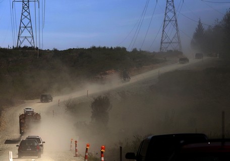
Mark Mulligan / The Herald Vehicles kick up dust as they travel eastbound on the service road bypass of Highway 530 toward Darrington Tuesday afternoon. Photo taken 20140429
OSO — The single-lane access road that bypasses the debris field of the Oso mudslide opened Tuesday morning.
It didn’t take long for grateful commuters to line up. State Department of Transportation spokesman Travis Phelps said as many as 60 vehicles at a time queued up to make the trip past the slide zone on the first day.
The access road off Highway 530 is accessible around the clock to local traffic, providing a much-needed lifeline to Darrington.
All trips are escorted through with a pilot car, leaving eastbound at the bottom of the hour and westbound at the top of the hour.
In many ways, it’s like a ferry line for passage to a remote island, with cars queueing up and neighbors getting out to chat to await the signal for the convoy to move forward.
Naomi Lieurance had gone to an appointment in Mount Vernon Tuesday morning with her shi tzu, Harley, via the Highway 20 route.
She had heard about the road opening during the day and was now waiting in line in Oso to return home to Darrington, hoping the new route will improve her access to the rest of the county.
“It’s got to be better than the Mountain Loop Highway,” she said.
She chatted in line with fellow Darrington resident Jake Sowers, who came over the access road earlier in the morning with his wife and was now heading home.
“I didn’t think it was as bad as I thought it was,” Sowers said. Approximately two dozen vehicles, including several logging trucks, made the 1:30 p.m. trip past the slide area to Darrington.
The view along the two-mile access road is not for the faint of heart, however.
The route skirts the edges of the slide zone. Trackhoes and construction vehicles below are dwarfed by a surrounding sea of rolling hillocks of mud and giant piles of broken timber. An American flag hangs from halfway up a denuded tree trunk.
The convoy passes stands of birch trees with new leaves and a pile of mangled cars. Behind it all is the exposed slope of the 650-foot cliff that slammed down into the valley on March 22.
“The horrific magnitude of it doesn’t sink in until you’ve seen it,” said Sowers, who laid eyes on the slide for the first time Tuesday morning.
A former ship’s mate, Sowers said, “I’ve seen some sad things in my life. I once surveyed a sunken ship, and this is right up there with it.”
The unpaved route is steep in places, with the convoy kicking up dust as it creeps over the hills.
According to the transportation department, only local traffic will be able to use the access road, and logging trucks will be able to use the road between 5 a.m. and 5 p.m.
No vehicles pulling trailers are permitted. The speed limit is a constant 10 miles per hour, and no stopping is permitted along the two-mile route.
The pilot cars and security at the two ends of the road are staffed by contractors hired by the state. Granite Construction Co. of Everett has been awarded a $3.4 million contract to maintain the access road and drive the pilot cars. Another firm, Seattle-based Central Protection, is providing security services.
The route is expected to remain open until at least one lane of Highway 530 is reopened. When that will happen is not immediately known, Phelps said.
MARYSVILLE — A long-term project that will ultimately alleviate some of Marysville’s downtown traffic backups will take a step forward this month.
Traffic flow downtown is hampered by the Burlington Northern Santa Fe rail line that cuts through the heart of the city. All the local streets downtown cross it at grade, leading to major backups whenever a freight train rolls through town.
Key to untangling that mess is where I-5 and Highway 529 meet just south of downtown. The idea is to rebuild the interchange, making it possible for northbound traffic on I-5 to enter town on Highway 529, bypassing the railroad tracks.
The current on- and offramps in the interchange only serve traffic going across Steamboat Slough and the Snohomish River to and from north Everett. The Fourth Street exit off I-5 drops traffic just west of the tracks, and a long train can keep traffic backed up all the way onto the freeway.
The city has budgeted $1.5 million this year for an initial design and planning proposal for the interchange project, Chief Administrative Officer Gloria Hirashima said.
That money, plus another $500,000 provided by Snohomish County, will fund the initial design work.
Mayor Jon Nehring highlighted the project in his State of the City speech last week, pointing out that the city would be able to take that preliminary plan to the state or federal government to get money to build the full interchange.
While it is still too early to put a price tag on the project, similar types of interchange expansion projects run in the $35 million to $40 million range, Hirashima said.
The City Council is expected to award a contract for the work to Bellevue-based engineering firm HDR Inc., probably this month, Hirashima said.
Over the longer term, the city also plans to investigate two other interchanges on I-5 for possible changes.
The main downtown interchange to Fourth Street needs improving, Hirashima said, and traffic backups there are also a contributor to downtown congestion.
The second location is where 156th St. NE crosses over I-5 near the north end of the city. The city’s Smokey Point Master Plan would transform 675 acres of agricultural land east of the overpass into a commercial and light industrial manufacturing center that could provide 10,000 new jobs to the region.
Transforming the overpass into a full interchange would improve access to the area and reduce the amount of traffic on 172nd Street NE that development is expected to bring.
“We’re very dependent on I-5 to move people back and forth, so we’re interested in working with the state to talk about improving interchanges,” Hirashima said.
MARYSVILLE — Drivers who use the Interstate 5 off-ramps to Fourth Street in Marysville and Marine View Drive in Tulalip may experience increased congestion beginning the morning of Tuesday, May 7.
The Tulalip Tribes are working on a water line project on Marine View Drive just west of I-5. The project will reduce Marine View Drive at 31st Avenue NE to one lane in each direction around-the-clock from 9 a.m. on Tuesday, May 7, through 8 p.m. on Friday, May 10.
Drivers should allow extra time or consider using alternate routes between 11 a.m. and 7 p.m. on each of those days, when 900 cars per hour travel west on Marine View Drive. Backups could affect the northbound and southbound I-5 off-ramps to Fourth Street.
Washington State Department of Transportation traffic engineers will monitor the ramps throughout the closure, and adjust the interchange signals as needed. The overhead message sign on northbound I-5 near Everett will also be used to alert drivers to congestion at the interchange.
Drivers can use one of WSDOT’s many travel resources, including the Seattle area traffic map, with its Marysville-area cameras, and @WSDOT_traffic on Twitter.
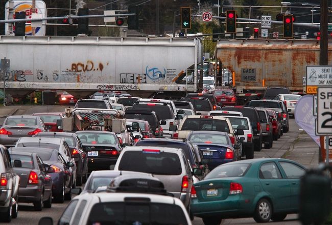
Dan Bates / The Herald Eastbound Marysville traffic, coming off I-5 from both northbound and southbound ramps, jams up at the Fourth Street train crossing April 9.
MARYSVILLE — When it comes to traffic backups from more coal trains, Marysville is Snohomish County’s ground zero.
Of 33 street crossings on BNSF Railway’s north-south line in the county, 16 — nearly half — are in Marysville.
Many of them already are congested.
Even now, at Fourth Street downtown, trains cause drivers to wait through the equivalent of three or four red lights, according to one traffic study.
Adding trains would make it that much harder for people who live in the city to get in and out, would delay access to businesses and cause serious problems for fire, ambulance and police service, Marysville Mayor Jon Nehring said.
The proposed $650 million Gateway Pacific terminal would serve as a place to send coal, grain, potash and scrap wood for biofuels to Asia. Trains would bring coal from Montana and Wyoming across Washington state to Seattle and north to Bellingham. Supporters point to the jobs that would be generated by the new business.
The terminal also is expected to generate up to 18 more train trips through Snohomish County per day, nine full and nine empty.
This would roughly double the number of trains that currently travel between Everett and Bellingham each day.
Other cities that could be affected by delays from more trains are Edmonds and Stanwood. In Mukilteo and in Everett, the tracks run through underpasses or tunnels at major arterials.
Marysville is in a unique position because the city is long and skinny north and south. The tracks run its entire length, right between Marysville’s two busiest north-south routes, I-5 and State Avenue.
In the case of State, at some crossings, the tracks are right next to the arterial. And State Avenue and I-5 are only about a half-mile apart through much of the city.
How much money will be needed for bridges, underpasses and rail improvements — and who would pay — is a long way from being determined.
Railroads are obligated by federal law to pay only a maximum of 5 percent of the cost of new bridges or tunnels deemed necessary to offset delays from added train traffic, according to Courtney Wallace, a spokeswoman for BNSF Railway in Seattle. The railroad owns the tracks from Seattle to the Canadian border.
“We would work with city officials to identify funding and work with them to see where the funding could come from, whether it’s federal dollars, state dollars or local dollars,” she said.
Wallace said she didn’t know if the company proposing the plan, SSA Marine of Seattle, would pitch in to cover any of the costs. Craig Cole, a spokesman for SSA Marine, declined to comment on the topic.
Even if money is available for road fixes, Marysville’s choices are limited.
Because of the closeness of the tracks to State Avenue and I-5, building overpasses is not even an option, city public works director Kevin Nielsen said.
Officials with Marysville and the state Department of Transportation — to name just a couple of agencies that submitted letters during last fall’s comment period on the plan — asked that potential improvements and costs be addressed in upcoming environmental studies.
From September through January, about 14,000 people registered comments in hearings and in writing with the three agencies reviewing the plan — the state Department of Ecology, the U.S. Army Corps of Engineers and Whatcom County.
It’s too early to tell exactly what subjects the studies will include, said Larry Altose, a spokesman for the ecology department. It will likely be at least a few months before the topics for study are determined and a year before the first draft of the study is done, Altose said.
This would be followed by another comment period and the final study, which would likely take at least another year.
Many environmental groups, local governments and individuals have come out against the plan. Their concerns, in addition to traffic at crossings, include pollution from coal dust and climate change.
One of the rail crossings is at 271st Street NW in the heart of Stanwood. Mayor Dianne White, however, doesn’t believe the extra trains would cause major problems.
“I don’t see it messing it up that much. They don’t stop, they keep going,” she said.
She added, however, that “I really feel for Marysville. It could completely block the whole city.”
Other crossings in the Silvana area and north of Stanwood could face some rush-hour delays but traffic is lighter there than in Marysville.
On the positive side, the plan is projected to create 4,400 temporary, construction related jobs and 1,200 long-term positions, according to SSA Marine.
“If they don’t build that Cherry Point terminal, (the trains) are going to keep going into Canada like they are now and we don’t get 2,000 jobs,” White said.
Rep. Rick Larsen, whose district includes Marysville as well as Bellingham where the project is planned, came under fire in his re-election campaign last year for backing the coal terminal. At the time, he called it a difficult decision, but said he supported the terminal because of the thousands of unemployed people who live in Whatcom County.
He said in a statement on Friday that “potentially negative outcomes” should be determined in the environmental review.
“If the (study) identifies traffic impacts, the project sponsor would and should be responsible for paying for improvements to mitigate those problems,” he said.
In Edmonds, the city has only two crossings, but one of them sits at the entrance to the ferry dock at the foot of Main Street. The other, at Dayton Street, controls access to much of the waterfront, including the Port of Edmonds marina.
State transportation officials, in written comments on the Gateway Pacific plan last fall, said two of 25 sailings per day were recently eliminated from the Edmonds-Kingston run because waits for trains were causing the boats to run behind schedule.
A plan proposed long ago, but shelved by a lack of funding, called for building a new ferry terminal at the south end of Edmonds where a bridge could be built over the tracks to carry ferry traffic.
The transportation department, in its letter, asked that this plan be re-examined in the environmental study, as well as the possibility of a bridge or tunnel at the Main Street crossing, and restricting train traffic during busy travel periods.
More than twice as many trains run per day on weekdays in south county than from Everett north — 49 compared to 19. Very few of the roads north of Everett, however, have bridges or underpasses at the train tracks.
Of the trains running in both directions between Everett and Seattle, about 35 are freight trains, BNSF spokesman Gus Melonas said. Amtrak Cascades and Empire Builder trains add another six every day, while Sounder commuter trains add another eight on weekdays. Mudslides have canceled an increasing number of these trains in recent years.
Adding 18 trains per day would bring the Monday-Friday total to 67.
About 15 freight trains run per day between Everett and Bellingham, Melonas said. Amtrak Cascades trains add four more for a total of 19 each day.
Adding 18 to this total would bring the total to 37.
Currently, up to four trains per day already carry coal on tracks between Seattle and Canada, Melonas said. Several terminals in British Columbia already ship coal, according to the Coal Association of Canada.
Trains are restricted to 30 mph in Marysville for safety reasons, meaning the barriers are down for six to eight minutes — the equivalent of three or four stoplight cycles — for the longer trains, according to the Gibson study.
The study was done for a group of business owners and residents in Whatcom County, said Tom Ehrlichman, an attorney for Salish Law of Bellingham, the group’s law firm at the time.
In downtown Marysville, the crossing at Fourth Street is less than a quarter-mile from I-5 — too close for an overpass, which would take up four blocks, Nielsen said.
Engineers have looked at tunneling under the tracks, but the dip would have to be steep because of the proximity to the freeway. Also, high ground water at that location would make the underpass susceptible to flooding, he said.
At 88th Street NE, the tracks are just a few feet from State Avenue.
“We could go over it, but you would end up way over on the other side of State Avenue in a neighborhood somewhere, and you’d have to have loop-back ramps over people’s houses to get back to State,” Nielsen said.
Because the tracks at 88th and 116th Street NE are so close to I-5, sometimes, when a long train goes through, traffic backs up onto the freeway, according to the Gibson study.
In fact, the extra trains could negate the benefits of the city’s $2 million widening of 116th completed a few years ago, the study says.
The study shows the street having carried 20,000 automobiles per day in 2011. For 88th Street NE and Fourth Street, the numbers are 30,000 each. Of this 80,000 total, about 7,000 of those were in the evening rush hour.
Because of the problems with building overpasses, city officials feel the best solution is to build an off-ramp from northbound I-5 directly to Highway 529 and the new Ebey Slough Bridge. This ramp would carry northbound drivers over the tracks as they exit the freeway, dropping them directly into the city and keeping them from having to sit at crossings at Fourth, 88th or 116th.
This project would cost about $1.8 million, said state Sen. Nick Harper, D-Everett.
So far in this year’s session of the Legislature, no money has been included for the ramp. Nehring said the project could potentially be included in a package to be sent to voters.
There’s the potential for some traffic snarls this weekend around the Sodo stadiums, the Alaskan Way Viaduct and on I-5, so be prepared and plan ahead.
Here’s a list of what’s happening:
The Viaduct is closed from 6 a.m to 5 p.m. Saturday and from 6 a.m. to noon Sunday, for its routine semi-annual inspection.
The on-ramp from the West Seattle Bridge route (elevated Spokane Street) to southbound I-5 will close from 10 p.m. Friday until 5 a.m. Monday, to repair expansion joints between the elevated bridge spans.
Sounders FC play a match Saturday night at CenturyLink Field, against the Montreal Impact, drawing an expected 40,000 fans.
Emerald City Comicon runs Friday, Saturday and Sunday, bringing 19,000 people to the state convention center.
A running event, the Hot Chocolate 15k/5k, will close the Aurora Bridge on Sunday from 6:15 a.m. to 11 a.m., and draw up to 12,000 people to Seattle Center and surrounding streets.
Three of four southbound lanes of I-5, from Green Lake to the Ship Canal Bridge, will close Friday night and Saturday night, from 10 p.m. to 10 a.m., for pavement regrinding.
The state Department of Transportation’s homepage about weekend closures, and the DOT’s traffic app, can be found here.