More Japanese Tsunami Debris Will Wash Up This Winter On Northwest Shores, Scientists Predict

Shipping tote dislodged during the Japanese tsunami washed ashore near Seal Rock, Ore. in late November. It was covered with about 200 blue mussels. | credit: Oregon State University

By Jes Burns, OPB

Winter storms off the Oregon and Washington coastlines are expected to bring a new wave of debris from the 2011 tsunami in Japan. Scientists say objects are already washing ashore – with potentially invasive organisms riding along.

In March, 2011 an earthquake and tsunami devastated a large swath of eastern Japan. The tsunami reached heights of over 100 feet in some places, washing large quantities of manmade materials out to sea. Japanese officials estimate that about 1.5 million tons of debris floated out into the Pacific.

Oregon State University marine scientist John Chapman questions the accuracy of that number, but says current tallies of what’s washed ashore on the U.S. West Coast are much lower than that.

“If we look at the amount of debris that we’ve found on the shore. And we try to estimate the poundage of debris and add it all up, it’s not even close,” he said. “So, where is it?”

Chapman says it very well could still be out in the ocean, waiting on the right combination of currents, winds and other factors to bring it ashore in the Pacific Northwest.

So far the tsunami debris has come over in waves. It started with buoys, polystyrene foam and two massive floating docks. The next winter, it was building materials, like lumber. Last winter, a parade of small boats started washing up.

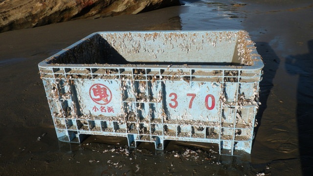
And now the first large object of the season – a 4-by-5 foot shipping tote – has washed up near Oregon’s Seal Rock.

The common feature of all these items is the presence of coastal marine organisms that hitched a ride over from Asia.

“This is the biggest experiment in marine invasion ecology that’s ever happened. It’s unprecedented,” Chapman said.

He said open oceans are the marine equivalent of deserts: there’s nothing out there. At least, nothing of substance, nutrient-wise that coastal organisms would need to survive. This was the prevailing thought among marine scientists – until that first Japanese dock section washed up in June, 2012 on the Oregon Coast.

“That was the first time that anyone ever considered that marine organisms could drift across the ocean. It wasn’t as if they didn’t think about it, we assumed that it wasn’t possible,” he said.

As the years passed and the debris continued to circulate in the North Pacific, Chapman assumed the amount of living coastal organism would decrease. Again, he’s been proven incorrect.

“We’re still finding species that we haven’t seen before. It doesn’t make sense to us,” he said. “We shouldn’t be doing that, but it seems to be happening.”

The plastic shipping tote that washed up in Oregon in late November was covered in about 200 blue mussels.

Yet, just because non-native marine organisms are washing up on the West Coast doesn’t mean they’re establishing populations here; it doesn’t mean they aren’t, either.

The question is currently being studied by several groups using a variety of methods, from visual surveys to genetic testing.

But the organisms are very tiny and the West Coast is very large. And so far none have been found that can specifically be connected to the tsunami.

“If it was a herd of bison that came across, it would be a no-brainer; we could go out and find it if they got here,” Chapman said.

“But these things aren’t bison. They’re little tiny things – sometimes diseases and parasites. And even if they are here, sometimes we don’t find them for years.”

Despite the challenges facing scientists, Chapman said the waves of tsunami debris present an unprecedented opportunity. Between now and May, he expects to see another round data wash ashore on the coast of the Pacific Northwest.

In Hawaii, Hints of a Giant Alaska Tsunami


By Ned Rozell | Geophysical Institute

Jan 15, 2014 AlaskaNativeNews.com

Clues from a crater-like sinkhole on the island of Kauai point back to a giant wave that came from Alaska at about the time European explorers were pushing west, seeing the Mississippi River for the first time.

The Makauwahi Sinkhole on Kauai, which contains ocean deposits carried there by a tsunami, probably generated from an earthquake off the Aleutians about 500 years ago.

The Makauwahi Sinkhole on the southeast shore of Kauai holds the mysterious equivalent of about nine shipping containers full of rocks, corals and shells from the Pacific Ocean. For the material to breach the amphitheater-like limestone walls of the feature required a wave about 25 feet high, said Rhett Butler of the Hawaii Institute of Geophysics and Planetology in Honolulu. Butler gave a presentation on the subject at the Fall Meeting of the American Geophysical Union held in San Francisco in December 2013.

That wave probably came from a great Aleutian earthquake, Butler said. The tsunami probably struck between the years of 1540 and 1660, according to dating of the organic materials within the sinkhole.

The great tsunami story starts with David Burney’s explorations of caves within the limestone complex. While Burney, an archaeologist, ecologist and director of conservation with the National Tropical Botanical Garden of Kauai, was trowling for and finding evidence of ancient people, he also discovered the layer of ocean materials about six feet below the surface.

Butler noticed Burney’s work and wondered how large a tsunami needed to be to breach the most vulnerable eastern wall of the sinkhole. He dialed up tsunami-generating earthquakes on a computer model until he found one that was plausible.

“A magnitude 9.25 in the eastern Aleutians gives us an 8-meter (about 25-foot) wave,” Butler said. “It gets (the sinkhole) wet. Smaller events do not get it wet.”

The tsunami Butler modeled had some collaborating evidence revealed at the same conference in San Francisco. The subject of last week’s column was a revealing hole on Alaska’s Sedanka Island first dug by Gary Carver of Kodiak. That research pit, inspired by a tsunami-carried driftwood log high above tideline, shows the sandy evidence of six big tsunamis, each spaced about 300 years apart. One of those sand deposits dates to the late 1500s. The wave that carried that sand might be the same tsunami that surged more than 2,000 miles and topped the wall of the Kauai sinkhole.

Butler, who lives in Honolulu, sees the evidence for a past great tsunami as a warning sign.

“Could an event like that happen here?” he said. “What are the ramifications for Hawaii?”

Current Hawaii tsunami inundation maps underestimate the water that would come from an earthquake similar to the one that soaked the sinkhole, Butler said.

“The beach (on Oahu) where President Obama spends Christmas gets entirely flooded,” he said. “(Oahu’s main) power plant is at 7.3 meters above sea level, and we could get run ups to 15 meters.”

His modeled epicenter for the earthquake that would have sent the tsunami to Kauai was in the Aleutian trench somewhere between Adak and Unimak islands.

“It was (located) between the 1946 and 1957 events, in an area focused right at us,” he said. “It looks like this one has happened before. There’s potential there and we have to confront that. This doesn’t mean it’s going to happen, but no one likes a surprise. A lot of people were surprised by Tohoku (Japan’s 2011 earthquake and tsunami).”

Since the late 1970s, the University of Alaska Fairbanks’ Geophysical Institute has provided this column free in cooperation with the UAF research community. Ned Rozell is a science writer for the Geophysical Institute. A version of this column first appeared in 2006.