Geophysicists link fracking boom to increase in earthquakes


By SEAN COCKERHAM

McClatchy Washington Bureau May 1, 2014

WASHINGTON — The swarm of earthquakes went on for months in North Central Texas, rattling homes, with reports of broken water pipes and cracked walls and locals blaming the shudders on the hydraulic fracturing boom that’s led to skyrocketing oil and gas production around the nation.

Darlia Hobbs, who lives on Eagle Mountain Lake, about a dozen miles from Fort Worth, said that more than 30 quakes hit from November to January.

“We have had way too many earthquakes out here because of the fracking and disposal wells,” she said in an interview.

While the dispute over the cause remains, leading geophysicists are now saying Hobbs and other residents might be right to point the finger at oil and gas activities.

“It is certainly possible, and in large part that is based on what else we’ve seen in the Fort Worth basin in terms of the rise of earthquakes since 2008,” William Ellsworth, a U.S. Geological Survey seismologist, said in an interview Thursday.

Ellsworth said the Dallas-Fort Worth region previously had just a single known earthquake, in 1950.

Since 2008, he said, more than 70 have been big enough to feel. Those include earthquakes at the Dallas-Fort Worth airport that scientists linked to a nearby injection well.

Ellsworth briefed his colleagues on his findings Thursday at the Seismological Society of America’s annual meeting in Anchorage.

Researchers also are investigating links between quakes in Kansas, Oklahoma, Ohio and elsewhere to oil and gas activities. USGS seismologist Art McGarr said it was clear that deep disposal of drilling waste was responsible for at least some of the quakes in the heartland.

“It is only a tiny fraction of the disposal wells that cause earthquakes large enough to be felt, and occasionally cause damage,” McGarr said. “But there are so many wells distributed throughout much of the U.S., they still add significantly to the total seismic hazard.”

While causes are under debate, it’s established that earthquakes have spiked along with America’s fracking boom. The USGS reports that an average of more than 100 earthquakes a year with a magnitude of 3.0 or more hit the central and eastern U.S. in the past four years.

That compares with an average rate of only 20 observed quakes a year in the decades from 1970 to 2000.

Regulators in Ohio found what they said was a probable connection between small quakes in the northeast corner of that state and the process of hydraulic fracturing, or fracking, in which high-pressure water and chemicals are pumped underground to break up shale rock and release the oil and natural gas inside.

But the USGS considers it very rare for fracking itself to cause earthquakes. Far more often the issue is quakes caused by the disposal of the wastewater into wells.

Fracking produces large amounts of wastewater, which companies often pump deep underground as an economical way to dispose of it. Injection raises the underground pressure and can effectively lubricate fault lines, weakening them and causing quakes, according to the USGS.

USGS seismologist Ellsworth said that near Fort Worth, two disposal wells were close enough to the earthquakes to be responsible. He said more research was needed.

Ellsworth and his colleagues, including seismologists from Southern Methodist University, in their presentation Thursday ruled out the idea that the falling level of a nearby lake might be contributing. But he said they couldn’t entirely reject the possibility of other natural causes — despite earthquakes being virtually unheard of in the region before 2008, which matches the start of the fracking boom.

Hobbs, of Eagle Mountain Lake, Texas, said she’d lived in the area since 1967 and never even considered the possibility of earthquakes.

“It’s spooky,” she said.

Salmon Conservation Efforts Honored


Jan 16, 2014

US Dept of Interior and US Geological Survey


SEATTLEToday the U.S. Department of Interior recognized the Pacific Northwest Aquatic Monitoring Partnership (PNAMP) for its conservation achievements focused on federally listed salmon species. The partnership was selected for a “Partnership in Conservation” award because it improves the scientific foundation for natural and cultural resource management and advances government-to-government relationships with Indian nations.

“The Department of the Interior is proud to recognize the accomplishments of those who are innovating and collaborating in ways that address today’s complex conservation and stewardship challenges,” Secretary Jewell said at an awards ceremony at the Interior headquarters in Washington today.  “These partnerships represent the gold standard for how Interior is doing business across the nation to power our future, strengthen tribal nations, conserve and enhance America’s great outdoors and engage the next generation.”

For the past eight years, the Pacific Northwest Aquatic Monitoring Partnership has promoted the recovery of Endangered Species Act listed salmon populations that represent a significant cultural resource for four Treaty Indian tribes and numerous non-Treaty tribes, as well as state commercial and sport fisheries. The partnership helps ensure program accountability and avoid duplication of efforts, which can pose problems for resource management.  The partnership also plays an important role in increasing the efficiency and effectiveness of water and biological monitoring and in management and exchange of data.

The “Pacific Northwest Aquatic Monitoring Partnership demonstrates that the whole truly can be more than the sum of its parts,” said Max Ethridge, U.S. Geological Survey’s Regional Director for the Northwest, “with partners working together in a time of scarce resources, the winner is conservation.”

The Pacific Northwest Aquatic Monitoring Partnership is a voluntary partnership of state, tribal and federal entities, supported by a small team of four USGS employees. Working to coordinate efforts of partners and other entities, the Pacific Northwest Aquatic Monitoring Partnership strives to improve efficiency and effectiveness of aquatic monitoring programs in the Pacific Northwest. Ultimately, these efforts contribute to the restoration of salmon populations and protection of aquatic habitats throughout the region.

“Salmon recovery is a shared goal,” said Jennifer Bayer, USGS Biologist who oversees the Pacific Northwest Aquatic Monitoring Partnership’s staff, “by focusing on common needs and sustaining collaboration among many entities, the Pacific Northwest Aquatic Monitoring Partnership enhances partners’ contributions to salmon conservation, ultimately working towards more effective monitoring and data collection efforts.”

The Pacific Northwest Aquatic Monitoring Partnership has created free, web accessible tools that help users discover and share data, document methods, and design and manage monitoring programs. The team also organizes workshops, standing workgroups and technical forums to share best practices for documentation, data sharing and data management related to salmon conservation.

The Pacific Northwest Aquatic Monitoring Partnership has a unique geographic, technical and policy scope.  The Pacific Northwest Aquatic Monitoring Partnership supports partners across Washington, Oregon, Idaho and northern California; engages technical experts in water quality, water supply, energy resources, endangered species recovery, invasive species, ecological modeling and data management; and reports annually to federal, state and tribal executive leadership.

The Partners in Conservation Awards recognize outstanding examples of conservation legacies achieved when the Department of the Interior engages groups and individuals representing a wide range of backgrounds, ages and interests to work collaboratively to renew lands and resources. At the annual awards ceremony, the Department of the Interior celebrated conservation achievements that highlight cooperation among diverse federal, state, local and tribal governments; public and private entities; non-profit organizations; and individuals.

A Continent of Ice on the Wane


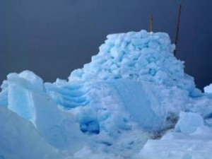
A whale-watching platform made of and sitting on sea ice north of Barrow. Photo by Ned Rozell.

Despite taking up as much space as Australia, the blue-white puzzle of ice floating on the Arctic Ocean is an abstraction to the billions who have never seen it. But continued shrinkage of sea ice is changing life for many living things. A few Alaska scientists added their observations to a recent journal article on the subject.


By Ned Rozell | Geophysical Institute

08/26/2013


Since 1999, the loss of northern sea ice equal to the size of Greenland is a “stunning” loss of habitat for animals large (polar bears) and small (ice algae and phytoplankton that feed a chain of larger creatures leading up to bowhead whales). So write the 10 authors that teamed to write “Ecological Consequences of Sea-Ice Decline,” featured in the August 2, 2013 issue of Science.

Eric Post of Penn State University, a former graduate student who studied caribou at the University of Alaska Fairbanks, is the lead author on the paper. When sea ice hit its minimum extent in the satellite era about a year ago, it got him thinking about how the loss of ice affects living things. That’s when Post, now the director of the Polar Center, rallied other contributors, from polar bear biologists to atmospheric scientists, to bring their results together.

“I think all of us as authors learned quite a bit about the importance of sea ice loss,” he said by email. “Individually, we each had a pretty clear idea of the implications of sea ice loss for certain parts of the arctic system, but none of us really grasped the full scope of the problem.”

Starting at the smaller end of things, the scientists point out that freshening of the Arctic Ocean caused by melting of sea ice may cause smaller types of plankton to thrive.

Arctic foxes, great wanderers of sea ice, will be limited by less of it, which would decrease the spread of rabies they sometimes carry from Russia’s mainland to Svalbard.

Walrus, which suck clams out of their shells with piston-like tongues, use sea ice as a resting spot between dives to the ocean floor. In recent years, people have seen more walruses using shorelines as haul-out spots; U.S. Geological Survey scientists counted 131 carcasses at one of these sites in September 2009. They wrote that the deaths, perhaps because of exhaustion or trampling, “appear to be related to the loss of sea ice over the Chukchi Sea continental shelf.”

In Canada’s arctic, “later freeze-ups and increased shipping traffic should shift or prevent the annual migration of the Dolphin and Union caribou herd,” the Science authors wrote. Parasites that feed off the caribou might increase because of this, but diseases spread by wandering caribou might decrease.

Polar bears need sea ice to hunt their favorite food, seals. As the sea ice shrinks, polar bears may be driven to land, where brown bears might outcompete them or hybridize with them.

The two UAF scientists who added to the report are Uma Bhatt, who studies the atmosphere, and Skip Walker, an expert on tundra plants. They have both done work to prove that the loss of sea ice has made the Arctic a greener place.

How might that happen? With less ice acting as a mirror for sunlight, the darker ocean absorbs more heat, which in turn warms the coastlines touching the Arctic Ocean. That warm air encourages plants to convert sunlight into growth at a higher rate and lengthens the growing season. Woody shrubs are becoming more numerous and taller, shouldering out smaller tundra plants. And the most extreme region of far north plants — a swath of bryophytes, lichens, blue-green algae and a few other non-woody species that make up what Russians call “polar desert” — seems to be headed for extinction.

The study helped lead-author Post envision northern sea ice as he would a great boreal forest or caribou herd scattered across an arctic plain.

“Sea ice is a living system,” Post said. “And not only does it harbor and sustain life, which is obviously affected by its loss, its disappearance influences the climate systems that affect life on other parts of the planet. We’ve come a long way in understanding how the loss of vast areas of mature tropical rainforest affects everything from indigenous cultures to species to ecosystems; our views of sea ice loss need to catch up with that understanding.”

Since the late 1970s, the University of Alaska Fairbanks’ Geophysical Institute has provided this column free in cooperation with the UAF research community. Ned Rozell is a science writer for the Geophysical Institute.

– See more at: http://alaska-native-news.com/the-arctic/9157-a-continent-of-ice-on-the-wane.html#sthash.KOPiL9DH.dpuf

Some Volcanoes ‘Scream’ at Ever-Higher Pitches until They Blow their Tops

It is not unusual for swarms of small earthquakes to precede a volcanic eruption. They can reach a point of such rapid succession that they create a signal called harmonic tremor that resembles sound made by various types of musical instruments, though at frequencies much lower than humans can hear.

By Vince Stricherz | University of Washington 07/15/2013


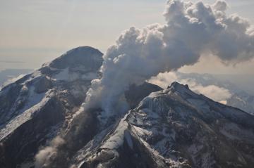
Redoubt Volcano’s active lava dome as it appeared on May 8, 2009. The volcano is in the Aleutian Range about 110 miles south-southwest of Anchorage, Alaska.Image-Chris Waythomas, Alaska Volcano Observatory

A new analysis of an eruption sequence at Alaska’s Redoubt Volcano in March 2009 shows that the harmonic tremor glided to substantially higher frequencies and then stopped abruptly just before six of the eruptions, five of them coming in succession.

“The frequency of this tremor is unusually high for a volcano, and it’s not easily explained by many of the accepted theories,” said Alicia Hotovec-Ellis, a University of Washington doctoral student in Earth and space sciences.

Documenting the activity gives clues to a volcano’s pressurization right before an explosion. That could help refine models and allow scientists to better understand what happens during eruptive cycles in volcanoes like Redoubt, she said.

The source of the earthquakes and harmonic tremor isn’t known precisely. Some volcanoes emit sound when magma – a mixture of molten rock, suspended solids and gas bubbles – resonates as it pushes up through thin cracks in the Earth’s crust.

But Hotovec-Ellis believes in this case the earthquakes and harmonic tremor happen as magma is forced through a narrow conduit under great pressure into the heart of the mountain. The thick magma sticks to the rock surface inside the conduit until the pressure is enough to move it higher, where it sticks until the pressure moves it again.

Each of these sudden movements results in a small earthquake, ranging in magnitude from about 0.5 to 1.5, she said. As the pressure builds, the quakes get smaller and happen in such rapid succession that they blend into a continuous harmonic tremor.

“Because there’s less time between each earthquake, there’s not enough time to build up enough pressure for a bigger one,” Hotovec-Ellis said. “After the frequency glides up to a ridiculously high frequency, it pauses and then it explodes.”

She is the lead author of a forthcoming paper in the Journal of Volcanology and Geothermal Research that describes the research. Co-authors are John Vidale of the UW and Stephanie Prejean and Joan Gomberg of the U.S. Geological Survey.

Hotovec-Ellis is a co-author of a second paper, published online July 14 in Nature Geoscience, that introduces a new “frictional faulting” model as a tool to evaluate the tremor mechanism observed at Redoubt in 2009. The lead author of that paper is Ksenia Dmitrieva of Stanford University, and other co-authors are Prejean and Eric Dunham of Stanford.

The pause in the harmonic tremor frequency increase just before the volcanic explosion is the main focus of the Nature Geoscience paper. “We think the pause is when even the earthquakes can’t keep up anymore and the two sides of the fault slide smoothly against each other,” Hotovec-Ellis said.

She documented the rising tremor frequency, starting at about 1 hertz (or cycle per second) and gliding upward to about 30 hertz. In humans, the audible frequency range starts at about 20 hertz, but a person lying on the ground directly above the magma conduit might be able to hear the harmonic tremor when it reaches its highest point (it is not an activity she would advise, since the tremor is closely followed by an explosion).

Scientists at the USGS Alaska Volcano Observatory have dubbed the highest-frequency harmonic tremor at Redoubt Volcano “the screams” because they reach such high pitch compared with a 1-to-5 hertz starting point. Hotovec-Ellis created two recordings of the seismic activity. A 10-second recording covers about 10 minutes of seismic sound and harmonic tremor, sped up 60 times. Aone-minute recording condenses about an hour of activity that includes more than 1,600 small earthquakes that preceded the first explosion with harmonic tremor.

Upward-gliding tremor immediately before a volcanic explosion also has been documented at the Arenal Volcano in Costa Rica and Soufrière Hills volcano on the Caribbean island of Montserrat.

“Redoubt is unique in that it is much clearer that that is what’s going on,” Hotovec-Ellis said. “I think the next step is understanding why the stresses are so high.”

The work was funded in part by the USGS and the National Science Foundation.

Source: University of Washington