Long, Warm Summer On Tap According To Weather Service Outlook

By Tom Banse, NW News Network

The supercomputers at the National Weather Service’s Climate Prediction Center have crunched long-term trends to produce an outlook for June, July and August. For most of the Northwest, the forecast gives a strong probability of above-normal temperatures.

National Weather Service is forecasting a strong probability of above-normal temperatures in June, July and August for most of the Northwest.
Credit National Weather Service


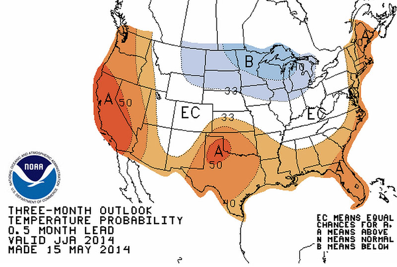
Seattle-based meteorologist Johnny Burg said the trend is strongest along the West Coast and becomes less pronounced as you go inland to Idaho.

“Usually our summers here are pretty warm and dry compared to the weather patterns throughout the year,” Burg said. “But what the CPC is saying is that we are looking at maybe having warmer than normal temperatures for this summer.”

The summer outlook for rainfall is neutral for the Pacific Northwest, but calls for above average rainfall chances in the central Rockies. There’s no drought relief in sight for parched rangelands in southern Oregon and southwest Idaho.

The Climate Prediction Center notes a transition to El Niño conditions is underway in the tropical Pacific, but that global weather phenomenon is not driving the forecast for a warmer than normal summer in the Northwest. Burg said that there is usually a lag before El Niño’s effects can be seen in the region’s local weather.

Statement from Quinault Nation concerning high winds

Quinault

The Quinault Indian Nation is cooperating with the U.S. Corps of Engineers, which has placed more than 800 tons of rock since 8 a.m. this morning, creating a secondary seawall in preparation for heavy rains and high winds, with gusts anticipated as high as 65-70 m.p.h. over the weekend. The seawall has already been breached in several locations, jeopardizing homes on the Reservation. Swells of 20-35 feet are anticipated. Dump trucks have lined up to dump their loads all day, building a four foot berm so far, all along the sea wall, and work is expected to continue through the night, according to John Preston, Quinault Tribal Emergency Services Coordinator.

“Our first priority is the safety of our people, their property and our natural resources. We will do all in our power to support this project and see that this work gets done,” said Fawn Sharp, Quinault Tribal President.

Snow flurries across Puget Sound into weekend


While it's certainly cold enough to snow, forecasters say the only real chance of snow may show up in a flurry. (AP)
While it’s certainly cold enough to snow, forecasters say the only real chance of snow may show up in a flurry. (AP)

BY Stephanie Klein  on December 5, 2013


MyNorthwest.com


While it’s certainly cold enough to snow, forecasters say the only real chance may show up in a flurry.

KING-5 Meteorologist Rich Marriott says no significant accumulations are expected. As the system moves south over the Olympic Peninsula and down to Northern California, another surge of cold air will move in from Canada.

Temperatures are expected to dip even lower as the new system moves in, which will bring with it gusty winds for the Northern counties and foothills. Gusts could reach 45 miles per hour Friday morning.

The cold snap isn’t expected to end until Monday when a system from the south rolls in. In the meanwhile, the lowest temps of the week are expected on Saturday morning when forecasters say the mercury may reach the teens and single digits across inland locations. We could even break a record low at Sea-Tac.

As the temperatures warm up and precipitation moves in, forecasters say we may see snow or freezing rain in some locations.

Beyond Tuesday, Marriott says we should be back to normal Western Washington weather with rain in the lowlands and snow in mountains.

Monsanto just dropped $1 billion on better weather forecasts

John Upton, Grist

Congressional paralysis is freezing or slashing national spending on weather forecasting and monitoring. Plans to deploy a next-generation array of satellites known as COSMIC-2 could be cut by lawmakers as part of the sequester spending cutsif only they would pass a budget. And workers at NASA, which provide data used by climate researchers the world over, are being furloughed.

But Monsanto — that profitable agro-corporation that wields ever-increasing power over the world’s food supply — is taking a smarter approach. As the effects of climate change devastate crops the world over, Monsanto has announced it is buying the Climate Corporation for $930 million. From the press release:

“Farmers around the world are challenged to make key decisions for their farms in the face of increasingly volatile weather, as well as a proliferation of information sources,” said David Friedberg, chief executive officer for The Climate Corporation. “Our team understands that the ability to turn data into actionable insight and farm management recommendations is vitally important for agriculture around the world and can greatly benefit farmers, regardless of farm size or their preferred farming methods. Monsanto shares this important vision for our business and we look forward to creating even greater experiences for our farmer customers.”

Modern Farmer explains the acquisition:

Climate Corporation underwrites weather insurance for farmers, basically in real time, using some of the most sophisticated data tools available to determine the risks posed by future weather conditions and events.

And the company doesn’t limit itself to weather data. As politicians, pundits, and people on the Internet continue to argue over whether climate change is real, the insurance industry has for years been operating under the assumption that it is. So Climate Corporation uses data from major climate-change models — the very ones that are under constant assault by doubters — in its calculations.

Climate Corporation manages an eye-popping 50 terabytes of live data, all at once. Besides climate-change models, data is collected from regular old weather forecasts and histories, soil observations, and other sources. The company collects data from 2.5 million separate locations. Given these numbers, it shouldn’t be surprising that Climate Corporation is basically alone in this market.

If Congress continues down the road of spending cuts and government shutdowns, private industry will soon know more about what’s going on with the weather than the government does.

Keep your raingear handy as two storms roll in today

Posted by Jennifer Sullivan

Seattle Times | September 5, 2013

Keep those slickers and umbrellas handy because this late summer rainstorm isn’t going away anytime soon.

A flood watch has been issued in Western Washington from noon today until 6 p.m. tomorrow.

The showers and thunderstorms that have been rolling through the region over the last several hours will continue, bringing up to 4 inches of rain in some places, said Jay Albrecht, meteorologist with the National Weather Service. Heavy rains in September are so uncommon that it is possible that records could be broken.

Seattle-Tacoma International Airport, where the area’s official readings are take

Photo form KomoNews.com

n, had just 2.65 inches of rain in the entire June-July-August period.

“If we get more than an inch and a third today, it will be at a record at Sea-Tac,” said Albrecht.

Two storm fronts are to blame for the unseasonal weather. One is the drenching Pacific storm that is rolling in now. A second storm is forming in the Cascades today and is expected to hit the region tonight, Weather Service officials said.

With all the rain, temperatures are expected to take a slight dip with today only in the low 70s. Temperatures tomorrow are expected to be in the upper 60s.

The approaching storm has prompted Seattle city officials to warn construction crews to inspect and maintain storm drain “socks,” temporary inserts often used to capture sediment from construction projects.

“The predicted weather system will not be huge by winter storm season standards, but for a time of the year that is normally dry it will be powerful,” said Seattle Public Utilities meteorologist James Rufo-Hill.

For the latest forecast, go to the National Weather Service web site.