Bringing life back to the Qwuloolt Estuary

Partners from the Tulalip Tribes and a dozen other agencies and groups, including Marysville, the U.S. Army Corps of Engineers, and NOAA, take in the view of the Qwuloolt Estuary on September 2, 2015. The levee was breached August 28, allowing the return of its native marshland.


By Micheal Rios, Tulalip News 


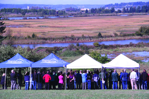
The Qwuloolt Estuary Restoration Project took 20 years to complete. The finish line was crossed on Friday, August 28, when massive excavators and bulldozers breached a levee and reopened 354-acres of historic wetlands to threatened Puget Sound chinook salmon. The levee breach culminated what has been recognized as the state’s second-largest ever estuary restoration project.

“This is a great, great day. It’s been a long time coming,” says Kurt Nelson, Tulalip Tribes’ Environmental Department Manager, at the September 2 levee breach celebration. “I’ve been on this project for 11 years and there have been many challenges and hurdles, but we’ve gotten through them all. What we have now is a 354-acre estuary wetland complex that saw its first tidal flows in 100 years last Friday [August 28].

“If you watch the live-stream webcam in fast motion, you’ll notice it’s almost like this site is breathing. The estuary is flooding and draining, flooding and draining with tidal waters, like a lung does with oxygen. It’s a nice comparison to bringing some life back to an isolated floodplain that hadn’t seen that kind of life in a longtime.”

The Qwuloolt Estuary Restoration Project (QERR) is a partnership of tribal, city, state and federal agencies aimed at restoring a critical tidal wetland in the Snohomish River estuary. The Qwuloolt Estuary is located within the Snohomish River floodplain approximately three miles upstream from its outlet to Puget Sound and within the Marysville City limits. The name, Qwuloolt, is a Lushootseed word meaning “salt marsh”.

Historically, the area was a tidal marsh and forest scrub-shrub habitat, interlaced by tidal channels, mudflats and streams. However, because of its rich delta soil, early settlers diked, drained and began using the land for cattle and dairy farming. The levees they established along Ebey Slough, as well as the drainage channels and tide gates, effectively killed the estuary by preventing the salt water from Puget Sound from mixing with the fresh water from Jones and Allen Creeks.

For the past 100 years the estuary was cut off from its connection with the tidal waters and denied the ability to act as a restorative habitat for wild-run chinook salmon and other native fish, such as coho and bull trout.  Through the cooperation of its many partners, this project has returned the historic and natural influences of the rivers and tides to the Qwuloolt.

The purpose of the project is to restore the Qwuloolt Estuary to historic natural conditions, while also mitigating some of the damage caused by the now defunct Tulalip Landfill on Ebey Island’s northwest edge. The former 145-acre landfill was operated on Tulalip Reservation land by Seattle Disposal Co. from 1964 to 1979 and become a Superfund site (polluted locations requiring a long-term response to clean up hazardous material contaminations) in 1995, before being cleaned up and capped in 2000.

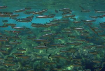
Qwuloolt will provide critical habitat for threatened Puget Sound chinook and other salmon, as well as for waterfowl and migratory birds. Native habitat and functioning tidal marsh ecosystem were lost when the estuary was diked and cut off from tidal influence. This project will restore tidal flows to the historic estuary and promote: Chinook, bull trout, steelhead, coho and cutthroat rearing habitat, salmon access to greater Allen Creek, migratory and resident bird habitat, water quality improvements, Native vegetation growth and restoration, and natural channel formation.

Trying to recover these critical estuary habits are crucial to migrating juvenile salmon for the salmon recovery effort in the Snohomish region. The Qwuloolt Estuary can now, once again, provide food and refuge for those fish. The intent of the project is to increase the production and quantity of those salmon that are extremely important to the Tribe and our cultural-economic purposes, as well as to the public and State of Washington.

“[Qwuloolt] is not only a nursery area for hundreds of thousands of juvenile salmon that migrate from the upper basins of the Snohomish that will come through this estuary and feed on various prey species and grow very rapidly, but also contributes to the survival of fish all over the Snohomish basin,” explains Nelson. “It will improve the water quality of Jones and Allen Creek, while being an extremely important bird habitat for migratory waterfowl, as well as restoring native wetland vegetation.”


The Qwuloolt Estuary Restoration Project is overseen by a planning team with representatives from the Tulalip Tribes, NOAA, USFWS, WDOE, U.S. Army Corps of Engineers, NRCS, and the city of Marysville.  Representatives from each entity were blanketed at a September 2 event celebrating the levee breach.
The Qwuloolt Estuary Restoration Project is overseen by a planning team with representatives from the Tulalip Tribes, NOAA, USFWS, WDOE, U.S. Army Corps of Engineers, NRCS, and the city of Marysville. Representatives from each entity were blanketed at a September 2 event celebrating the levee breach.


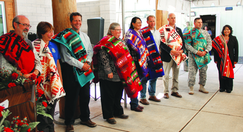
The US Army Corps of Engineers were responsible for the levee construction and the levee breach, while the Tribes were responsible for the channels, the berms, the planting, and some of the utility work that needed to be done. From beginning to end QERR was all about partnership and working together in getting this project done. The US Army Corps of Engineers, the Tulalip Tribes, the city of Marysville, Department of Ecology, National Oceanic and Atmospheric Administration, along with the Puget Sound Partnership and Fish and Wildlife services, all played instrumental roles in completing this project and it could not have been done without the collaboration each and every partner.

“As evidenced here today, it really has been a tremendous collaboration between the tribes and federal, state and local governments to bring this project through and really make a significant change for our environment,” says Col. John Buck of the U.S. Army Corps of Engineers. “Over the past century we’ve seen this continuing degradation of our environment in the northwest and it’s through collaboration and partnership we can really affect change.”

*The Qwuloolt Estuary project cost $20 million. That money was obtained over a 17 year period that involved federal, state and tribal money. It also includes settlement and foundation money. Property purchase was $6 million, $2 million in planning, design, permitting and studies, $10 million on the levee, and another $2 million on constructing channels, berms and all the interior work.


Qwuloolt is:

  • Physical stream restoration is a complex part of the project, which actually reroutes 1.5 miles of Jones and Allen creek channels. Scientists used historical and field analyses and aerial photographs to move the creek beds near their historic locations.
  • Native plants and vegetation that once inhabited the area such as; various grasses, sedges, bulrush, cattails, willow, rose, Sitka spruce, pine, fir, crab apple and alder are replacing non-native invasive species.
  • Building in stormwater protection consists of creating a 6 ½ acre water runoff storage basin that will be used to manage stormwater runoff from the nearby suburban developments to prevent erosion and filter out pollutants so they don’t flow out of the estuary.
  • Construction of a setback levee has nearly finished and spans 4,000 feet on the western edge on Qwuloolt. The levee was constructed to protect the adjacent private and commercial property from water overflow once the levee is breached.
  • Breaching of the existing levee that is located in the south edge of the estuary will begin after the setback reaches construction. The breaching of the levee will allow the saline and fresh water to mix within the 400-acre marsh.

Other estuary restoration projects within the Snohomish River Watershed include; Ebey Slough at 14 acres, 400 acres of Union Slough/Smith Island and 60 acres of Spencer Island. The Qwuloolt Estuary Restoration Project has been a large collaboration between The Tulalip Tribes, local, county, state and federal agencies, private individuals and organizations.


 Contact Micheal Rios at mrios@tulaliptribes-nsn.gov


NOAA to consider taking humpback whales off endangered list

Humpback_whale_noaaBy YERETH ROSEN yereth@alaskadispatch.com

June 25, 2014 Alaska Dispatch

Alaska’s humpback whales came a step closer to moving off the endangered species list this week when an arm of the National Oceanic and Atmospheric Administration issued a positive initial finding on the merits of the state’s petition to delist a population of the marine mammals.

On Wednesday, NOAA Fisheries announced a positive finding, which means the agency “has determined that the petition presents substantial scientific or commercial information indicating that the petitioned action may be warranted,” said a release on the finding.

The State of Alaska petitioned the agency in February to delist the central north Pacific population of humpbacks, which travels between Hawaii and Alaska. An estimate at that time put the entire north Pacific population at 21,800, up from about 1,000 in 1966, the year commercial whaling ended. The central north Pacific stock — the population segment targeted by the state’s petition — is believed to number at least 5,833, NOAA said Wednesday.

Another organization, the Hawai’i Fishermen’s Alliance for Conservation and Tradition, is also seeking delisting, but for the entire north Pacific population. NOAA issued a positive 90-day finding on that petition last August.

The positive findings on the Alaska and Hawaii group’s petitions mean NOAA will conduct status reviews of the central north Pacific and entire north Pacific populations. Those reviews generally take a year.

NOAA is already engaged in a status review of the global population of humpback whales, a project started in 2009 and not prompted by any petition, said Julie Speegle, a spokeswoman for the agency.

NOAA plans to combine the new north Pacific population reviews into the global study, Speegle said. “Within that status review, we will look at the different stocks,” she said.

Humpback whales exist in oceans all over the world, Speegle said. Within the north Pacific population, she said, there are three stocks — the central stock that is the subject of the Alaska petition, the western stock in Asia and the stock that swims off California, Oregon, Washington and Mexico.

If any delisting occurs, that could affect regulations that protect the whales, Speegle said.

“We would go back to the regulations to determine what may be necessary or what needs to be changed,” she said. But regulation changes depend on the outcome of the status review, a range of possibilities that includes a possible change to a listing of “threatened” from the current endangered listing, she said.

Quinault’s Taholah Lower Village to relocate due to ocean threats

Aerial view of Taholah's Lower Village.Photo courtesy of Larry Workman
Aerial view of Taholah’s Lower Village.
Photo courtesy of Larry Workman

By Brandi N. Montreuil, Tulalip News

TAHOLAH – On March 25, the encroaching waters of the Pacific Ocean awakened residents in Taholah, Washington, when their aging seawall was breached and flooded sections of their Lower Village. Now, the village is faced with relocation due to changes in climate resulting in rising sea levels, tsunami threats, and flood danger from the Quinault River.

The ancestral home of the Quinault people is classified as a tsunami hazard zone by the Washington Emergency Management Division and is no longer considered safe. As a result, a comprehensive master plan is being implemented that would move residents and government structures 120 feet above sea level to the Upper Village.

The risks were identified years before when the Quinault Indian Nation undertook a comprehensive analysis of the coastline after increased flooding in the Lower Village. The analysis showed deterioration of the protective berm that separates the Lower Village from the ocean water. With each large storm the ocean encroaches further into the village, making relocation necessary. “We first thought it was rain water, but in 2009 we did a walk down to the ocean line and we discovered the ocean was encroaching much worse than we thought,” said Councilman Larry Ralston, Quinault Indian Nation Treasurer.

What was uncovered was the deterioration of a protective berm that separated the Lower Village from the ocean water and with each large storm, the ocean encroached further into the village, making relocation necessary.

“We did a risk management plan and undertook an emergency preparedness evaluation and it was determined that not only are we vulnerable to the ocean encroaching, but the footprint of our Lower Village is vulnerable to liquefaction, so if we had a large earthquake, the village could actually sink

Larry Ralston, Quinault Indian Nation Treasurer, stands in front of his mother's house which will not be moved during the relocation of Taholah's Lower Village, and could face possible demolition along with other buildings that cannot be moved. Photo/ Brandi N. Montreuil, Tulalip News
Larry Ralston, Quinault Indian Nation Treasurer, stands in front of his mother’s house which will not be moved during the relocation of Taholah’s Lower Village, and could face possible demolition along with other buildings that cannot be moved.
Photo/ Brandi N. Montreuil, Tulalip News

into the earth,” said Fawn Sharp, Quinault Indian Nation President.

President Sharp explained the safety of current and future Quinaults is the main priority. “We have a sacred trust and duty to those who are deeply connected to the land and their homes. It is a mix in which we have to plan carefully. We have over 1,000 residents and we have our major retail outlet, the Taholah Mercantile. We have our jail facility, courthouse, daycare and head start, and k-12 school so a number of our critical programs are located right in the heart of the village.”

“As of right now we are in the process of undertaking a feasibility study. The study will fully assess the infrastructure and the number of residents at risk, putting together a plan that we can then take to federal appropriators and members of congress, and other federal agencies in an effort to relocate the village,” said President Sharp.

Preliminary estimates for relocation cost are near $65 million and include the need to acquire land adjacent to the Upper Village, and the building of infrastructures including roadways, utilities, housing, and businesses. The loss of generational history that holds cultural relevance to the Quinault people is something that is also being considered, as is the risk of the “big one” hitting.

“As a resident of the Lower Village, we think about tsunamis more often than not. For a lot of us, we grew up listening to the ocean and we know what the weather is going to be like just by hearing the waves. You are always listening to the ocean to monitor what is going on,” said Ralston.  “I am looking forward to the move, but I also know there are some houses that will be torn down like the one that my mother was born in in 1928. The worst case scenario if we don’t move everyone to higher ground, is that we get hit with a wave at two in the morning and we would only have two or three minutes to evacuate the Lower Village and we lose lives.”

Quinault elder James DeLaCruz Sr. stands by the recently reinforced Taholah seaswall, is among the handful of residents who do not plan to leave the Lower Village during Taholah's relocation. Photo/ Brandi N. Montreuil, Tulalip News
Quinault elder James DeLaCruz Sr. stands by the recently reinforced Taholah seaswall, is among the handful of residents who do not plan to leave the Lower Village during Taholah’s relocation.
Photo/ Brandi N. Montreuil, Tulalip News

With only two ways in and out of Taholah, the risk of liquefaction puts residents at a high risk during evacuation, as roads would be inaccessible. During the event of a tsunami wave residents have limited time to move to higher ground.

Tsunami warning systems in place in Taholah include a siren monitored by the National Oceanic and Atmospheric Administrator headquarters in Seattle. In the event of an earthquake or tsunami wave the siren will go off followed by a voice telling residents to evacuate. To date, the siren has only been used during monthly test drills.

“The benefit of the relocation will be knowing that our citizens are safe, said President Sharp. “The other benefit will be the planning process will have a lot of room to expand. We have a fairly large land base adjacent to the village that we are looking at developing. There will be opportunity to create space for building a private sector economy. We are getting direct input from our membership; if you could take just a blank space, how would you want to design a community? That is the exciting part of the planning stage. There are a lot of great ideas that are emerging from our citizens, and their vision and their view of what a future Taholah will look like.”

Although relocation is necessary, residents will not be forced to move. Some residents like Quinault elder James DeLaCruz Sr. knows he will not be relocating. His house butts against the seawall, and as he explains “The Lower Village has been a part of my life as long as I can remember and this is where my home is until nature changes that.

Taholah Mercantile, a Quinault Indian Nation enterprise, is the main, and only, source of perishable food shopping for residents in the Lower Village. It sits a block from the seawall and is at risk of flooding from rising sea levels. Photo/ Brandi N. Montreuil, Tulalip News
Taholah Mercantile, a Quinault Indian Nation enterprise, is the main, and only, source of perishable food shopping for residents in the Lower Village. It sits a block from the seawall and is at risk of flooding from rising sea levels.
Photo/ Brandi N. Montreuil, Tulalip News

“We believe that every citizen has that right,” said President Sharp. “We will do our best to educate our membership about the risk. We will do our best to provide our citizens the options for relocation, but ultimately we will respect that individual citizen’s absolute right to live where the Creator put them and the lands that were given to our ancestors.”

“Our ancestors had to be good stewards of the land. We have done that here at Quinault,” said President Sharp. “Yet we seem to be paying the price for others who don’t share the same values. Our ocean is becoming acidic, the ocean is encroaching into our ancient homelands, and the glaciers that feed the upper Quinault River and our prized sockeye salmon are disappearing. So while we have been good stewards, we are paying a heavy price for other peoples mistakes.”

The Taholah Relocation Master Plan includes the Quinault Planning Development and Kaul Design Associates. A three-year planning process will be implemented in phases and include gathering information, needs and choices of the community, and final plan preparation.


Brandi N. Montreuil: 360-913-5402; bmontreuil@tulalipnews.com


Tribes Recovering from Geoduck Ban

Mar 19th, 2014 Northwest Indian Fisheries Commission

Western Washington tribes are quickly recovering from a sudden ban in December 2013 on selling geoduck to China.

The Asian country claimed it received a shipment of geoduck from Ketchikan, Alaska, that had high levels of paralytic shellfish poisoning, and a shipment from Poverty Bay in Puyallup, Wash., that had high levels of arsenic.

Suquamish Seafoods employee James Banda packs geoduck for international shipping.

As a result, China announced it was banning all imports of bivalve shellfish from Washington, Oregon, Alaska and Northern California. This was just before the Chinese New Year, a lucrative time for harvesters and buyers, when geoducks are traditionally served.

“It was bad at the beginning because we didn’t know what was going on,” said Tony Forsman, general manager of the Suquamish Tribe’s Suquamish Seafoods, which regularly ships shellfish internationally. “China didn’t tell us for two weeks they were doing this.”

Officials from the National Oceanic and Atmospheric Administration (NOAA) have been working with Chinese officials to determine how they came to their conclusions and have been in close communication with Washington Department of Health and western Washington tribal officials about the progress. Officials from NOAA are meeting in person with officials from China’s General Administration of Quality Supervision, Inspection and Quarantine this month to further discuss the situation.

The shellfish in question from Poverty Bay passed all the rigorous tests needed to be exported to China, said David Fyfe, shellfish biologist for Northwest Indian Fisheries Commission.

“We’re working with China to figure out why we suddenly don’t meet their standards,” he said.

In the meantime, harvesters and buyers are continuing to send their catches to other Asian countries, including Vietnam. U.S. officials are asking China to reduce the ban area from the West Coast to just the two original areas of concern.

Suquamish Seafoods had to layoff nine employees in December – including those who sort, pack and ship the shellfish – but everyone was re-hired by mid-February. Suquamish Tribe harvesters annually gather nearly 500,000 pounds of geoduck.

“There have been blips in the market, such as having to sell smaller geoduck, plus market pressure forced prices down,” Forsman said. “We’ve all just had to adjust – divers, market, buyers, us. Things are fine now but we had to adjust and adjust fast.”

Despite the “blip”, it did prove that the United States shellfish quality control system works, Fyfe said. Harvesters have to meet the National Shellfish Sanitation Program standards, which includes providing information about the harvester, day and tract from which shellfish was harvested.


New Ocean Forecast Could Help Predict Fish Habitat Six Months in Advance

People are now used to long-term weather forecasts that predict what the coming winter may bring. But University of Washington researchers and federal scientists have developed the first long-term forecast of conditions that matter for Pacific Northwest fisheries.

By Hannah Hickey | University of Washington News and Information

September 4, 2013

“Being able to predict future phytoplankton blooms, ocean temperatures and low-oxygen events could help fisheries managers,” said Samantha Siedlecki, a research scientist at the UW-based Joint Institute for the Study of the Atmosphere and Ocean.

“This is an experiment to produce the first seasonal prediction system for the ocean ecosystem. We are excited about the initial results, but there is more to learn and explore about this tool – not only in terms of the science, but also in terms of its application,” she said.

A school of sardines. The tool will soon produce a months-long outlook for Pacific Northwest sardine habitat.Image-Wikimedia / Alessandro Duci - See more at: http://alaska-native-news.com/alaska-native-news-at-sea/9212-new-ocean-forecast-could-help-predict-fish-habitat-six-months-in-advance.html#sthash.JjthM2LO.dpuf
A school of sardines. The tool will soon produce a months-long outlook for Pacific Northwest sardine habitat.Image-Wikimedia / Alessandro Duci

In January, when the prototype was launched, it predicted unusually low oxygen this summer off the Olympic coast. People scoffed. But when an unusual low-oxygen patch developed off the Washington coast in July, some skeptics began to take the tool more seriously. The new tool predicts that low-oxygen trend will continue, and worsen, in coming months.

“We’re taking the global climate model simulations and applying them to our coastal waters,” saidNick Bond, a UW research meteorologist. “What’s cutting edge is how the tool connects the ocean chemistry and biology.”

Bond’s research typically involves predicting ocean conditions decades in advance. But as Washington’s state climatologist he distributes quarterly forecasts of the weather. With this project he decided to combine the two, taking a seasonal approach to marine forecasts.

The National Oceanographic and Atmospheric Administration funded the project to create the tool and publish the two initial forecasts.

“Simply knowing if things are likely to get better, or worse, or stay the same, would be really useful,” said collaborator Phil Levin, a biologist at NOAA’s Northwest Fisheries Science Center.

Early warning of negative trends, for example, could help to set quotas.

“Once you overharvest, a lot of regulations kick in,” Levin said. “By avoiding overfishing you don’t get penalized, you keep the stock healthier and you’re able to maintain fishing at a sustainable level.”

/tmp/tpc2e91792_36e0_416e_b69a_7de0af3744c9.psThe tool is named the JISAO Seasonal Coastal Ocean Prediction of the Ecosystem, which the scientist dubbed J-SCOPE. It’s still in its testing stage. It remains to be seen whether the low-oxygen prediction was just beginner’s luck or is proof the tool can predict where strong phytoplankton blooms will end up causing low-oxygen conditions, Siedlecki said.

The tool uses global climate models that can predict elements of the weather up to nine months in advance. It feeds those results into a regional coastal ocean model developed by the UW Coastal Modeling Group that simulates the intricate subsea canyons, shelf breaks and river plumes of the Pacific Northwest coastline. Siedlecki added a new UW oxygen model that calculates where currents and chemistry promote the growth of marine plants, or phytoplankton, and where those plants will decompose and, in turn, affect oxygen levels and other properties of the ocean water.

The end product is a nine-month forecast for Washington and Oregon sea surface temperatures, oxygen at various depths, acidity, and chlorophyll, a measure of the marine plants that feed most fish. Coming this fall are sardine habitat maps. Eventually researchers would like to publish forecasts specific to other fish, such as tuna and salmon.

The researchers fine-tuned their model by comparing results for past seasons with actual measurements collected by theNorthwest Association of Networked Ocean Observing Systems, or NANOOS. The UW-based association is hosting the forecasts as a forward-looking complement to its growing archive of Pacific Northwest ocean observations.

Siedlecki’s analyses suggest the new tool is able to predict elements of the ocean ecosystem up to six months in advance.

Researchers will present the project this year to the Pacific Fishery Management Council, the regulatory body for West Coast fisheries, and will work with NANOOS to reach tribal, state, and local fisheries managers.

If the forecasts prove reliable, they could eventually be part of a new management approach that requires knowing and predicting how different parts of the ocean ecosystem interact.

“The climate predictions have gotten to the point where they have six-month predictability globally, and the physics of the regional model and observational network are at the point where we’re able to do this project,” Siedlecki said.

Source: University of Washington

2012 Broke Climate Records, New Report Says


Surface temperatures in 2012 compared with the 1981 to 2010 average.Credit: NOAA map by Dan Pisut, NOAA Environmental Visualization Lab
Surface temperatures in 2012 compared with the 1981 to 2010 average.
Credit: NOAA map by Dan Pisut, NOAA Environmental Visualization Lab

by Becky Oskin, OurAmazingPlanet Staff Writer   |   August 06, 2013 04:17pm ET

2012 was a year of climate records, from temperatures to ice melt to sea level rise, a newly released report on the state of the global climate says.


Even though natural climate cycles have slowed the planet’s rising temperature, 2012 was one of the 10 hottest years since 1880, according to the report released today (Aug. 6) by the National Oceanic and Atmospheric Administration.


One reason the world’s warming is slower in recent years is because of recent La Niña conditions in the Pacific Ocean, which cause atmospheric and ocean temperatures to cool, said Tom Karl, director of NOAA’s National Climatic Data Center during a news teleconference.”There are a number of factors that cause climate to vary from year to year, but when you look back at long-term trends, temperatures have been increasing consistently,” he said.


But in the Arctic, surface temperatures rose twice as fast in the past decade as lower latitudes, said Jackie Richter-Menge, a report co-author and research civil engineer with the U.S. Army Corps of Engineers. “The Arctic continues to be a region where we have some of the most compelling evidence of the fact that global temperatures are warming,” she said.


Difference from average annual snow cover since 1971, compared with the 1966 to 2010 average. Snow cover has largely been below average since the late 1980s.Credit: NOAA
Difference from average annual snow cover since 1971, compared with the 1966 to 2010 average. Snow cover has largely been below average since the late 1980s.
Credit: NOAA

A strong and persistent southerly airflow in spring 2012 contributed to the Arctic’s record warmth, Richter-Menge said. The effects included a record-low summer ice pack extent in the Arctic Ocean, and surface melting across 97 percent of the Greenland Ice Sheet. Richter-Menge said researchers are also seeing long-term changes, such as more coastal vegetation growing in the Arctic tundra and rising permafrost temperatures.


“The near records being reported from year to year are no longer anomalies or exceptions,” Richter-Menge said. “They have become the norm for us and what we expect to see in the near future.” [5 Ways Rapid Warming is Changing the Arctic]


Ice melt from Greenland and glaciers elsewhere are contributing to sea level rise, according to the climate report. In the past year, sea level rose a record 1.4 inches (35 millimeters) above the 1983 to 2010 average, said Jessica Blunden, a climatologist at NOAA’s Climatic Data Center and lead editor of the report. “It appears ice melt is contributing more than twice as much as warming waters,” she said during the teleconference. As the ocean warms, water expands, contributing to sea level rise.


The annual State of the Climate report compiles climate and weather data from around the world and is reviewed by more than 380 climate scientists from 52 countries. The report can be viewed online.


The planet hit several records or near records in 2012, the report said. These include:


  • Record ice loss from melting glaciers. 2012 will be the 22nd year in a row of ice loss.
  • Near-record ocean heat content, a measure of heat stored in the oceans. When the ocean holds more heat than it releases, its heat content increases.
  • Record sea level rise of 1.4 inches above average.
  • Record-low June snow cover in the Northern Hemisphere. The June snow cover has declined 17 percent per decade since 1979, outpacing the shrinking summer Arctic sea ice extent by 4 percent.
  • Record-low summer Arctic sea ice extent. Sea ice shrank to its smallest summer minimum since record-keeping began 34 years ago.
  • Record-high winter Antarctic sea ice extent of 7.51 million square miles (19.44 million square kilometers) in September.
  • Record-high man-made greenhouse gas levels in the atmosphere. In 2012, for the first time, global average carbon dioxide concentrations hit 392 parts per million and exceeded 400 ppm at some observation sites. The number means there were 400 carbon dioxide molecules per 1 million air molecules.

Email Becky Oskin or follow her @beckyoskin. Follow us @livescience, Facebook & Google+. Original article on LiveScience.com.

Hawaii Ocean Debris Could Fill 18-Wheeler


Some of the 4781 bottle caps collected from Midway Atoll shorelines by a 9-member team from the PIFSC Coral Reef Ecosystem Division during a cleanup mission in April 2013.Credit: NOAA photo by Kristen Kell
Some of the 4781 bottle caps collected from Midway Atoll shorelines by a 9-member team from the PIFSC Coral Reef Ecosystem Division during a cleanup mission in April 2013.
Credit: NOAA photo by Kristen Kell

Elizabeth Howell, LiveScience Contributor   |   July 30, 2013

In an area of Hawaii, far removed from most human habitation, a recent cleanup effort yielded an 18-wheeler’s worth of human debris during a 19-day anti-pollution campaign this year.

The region, which includes Midway Atoll, some 1,200 miles (1,900 kilometers) from the Hawaiian mainland, acts as a “fine-tooth comb” in picking up debris from elsewhere, officials with the National Oceanic and Atmospheric Administration (NOAA) told LiveScience. Broken fishing gear, tattered nets and plastic fragments litter the water and land on the beaches.

As challenging as it is to clean up that much debris, it’s even more of an undertaking to remove it. Heavy machinery could damage the environment, so about 90 percent of the underwater cleanup is done by divers, said Kyle Koyanagi, NOAA’s marine debris operations manager.

“They physically go down and remove the net little by little with pocket knives, slowly cutting away at the debris that is entangled,” Koyanagi said. “They remove it from that environment, pull it in with their arms, hands and back, and transport it in small vessels on to larger support vessels.”

NOAA does this campaign every year, but the annual budget is in “soft money,” Koyanagi said, which means it’s vulnerable to budgetary effects such as sequestration.

Cleanup changes every year

The Coral Reef Ecosystem Division Marine Debris Project, run by NOAA’s Pacific Islands Fisheries Science Center, has collected 848 tons (769 metric tons) of debris —about the weight of 530 sedan-size cars —in the northwestern Hawaiian Islands since the program began in 1996.

Efforts began after pollution was identified as a major threat to monk seals, an endangered species native to Hawaii. Decades of built-up pollution required NOAA to spend anywhere from 60 to 120 days at sea between 2000 and 2005, when intensive anti-pollution measures began in earnest. [Video: Humans Hit the Oceans Hard]

With the buildup now addressed, the agency has now been in “maintenance mode” since 2006, picking up whatever gets washed into the area annually. A typical field season lasts 30 to 60 days.

“We put together an annual effort every year depending on our budget that gets allocated,” said Mark Manuel, NOAA’s marine ecosystems research specialist. “It will be some kind of survey effort, whether a shore-based, three-week mission or an extensive, two-month cleanup [at sea].”


James Morioka, Kerrie Krosky, Kristen Kelly, Tomoko Acoba, Kevin O’Brien, Kerry Reardon, Edmund Coccagna, Joao Garriques, and Russell Reardon (clockwise from upper right) pose on April 18 atop the large, 13,795-kilogram (about 30,400 lbs) pile of fishing gear and plastic debris collected during their 2013 cleanup effort around Midway Atoll.Credit: NOAA photo by Edmund Coccagna
James Morioka, Kerrie Krosky, Kristen Kelly, Tomoko Acoba, Kevin O’Brien, Kerry Reardon, Edmund Coccagna, Joao Garriques, and Russell Reardon (clockwise from upper right) pose on April 18 atop the large, 13,795-kilogram (about 30,400 lbs) pile of fishing gear and plastic debris collected during their 2013 cleanup effort around Midway Atoll.
Credit: NOAA photo by Edmund Coccagna

Turning nets to energy

The amount of debris collected varies wildly from year to year. Surveyed areas in Hawaii include the French Frigate Shoals, Kure Atoll, Laysan Island, Lisianski Island, Maro Reef, Midway Atoll and Pearl and Hermes Atoll.

This year’s efforts stayed on the shore due to budgetary concerns, Koyanagi added, which likely reduced the amount of debris collected, even though it could have filled a big rig.

“As you can imagine, the ship time is very expensive,” Koyanagi said. “Because of budget cuts this year, we could not afford to do a full-blown effort and get to the remote atolls.”

Once the debris is picked up, NOAA works to recycle as much of it as possible. Nets, for example, are sent to Schnitzer Steel Hawaii Corp. on the mainland, where they are chopped up for the City and County of Honolulu’s H-Power plant to convert into electricity.

The facility, run by Covanta Energy, burns the nets and generates steam, which is used to drive a turbine and create electricity.

Follow Elizabeth Howell @howellspace. Follow us @livescienceFacebookGoogle+. Original article on LiveScience.com.

Cruise to Set Sail to Investigate Ocean Acidification

NOAA Ship Fairweather in the Gulf of Alaska with namesake Mt. Fairweather.Credit: NOAA
NOAA Ship Fairweather in the Gulf of Alaska with namesake Mt. Fairweather.
Credit: NOAA

By Douglas Main, Staff Writer for LiveScience

July 25, 2013 06:01pm ET

The waters off the Pacific Northwest are becoming more acidic, making life more difficult for the animals that live there, especially oysters and the approximately 3,200 people employed in the shellfish industry.

Researchers from the National Oceanographic and Atmospheric Administration (NOAA) will set sail Monday (July 29) on a monthlong research cruise off the U.S. and Canadian West Coast to see how ocean acidification is affecting the chemistry of the ocean waters and the area’s sea life.

Ocean acidification occurs when greenhouse-gas emissions cause carbon dioxide to accumulate in the atmosphere and become dissolved in sea water, changing the water’s chemistry and making it more difficult for coral, shellfish and other animals to form hard shells. Carbon dioxide creates carbonic acid when dispersed in water. This can dissolve carbonate, the prime component in corals and oysters’ shells.

The world’s oceans are 30 percent more acidic than they were before the Industrial Revolution, scientists estimate.

This cruise follows up on a similar effort in 2007 that supplied “jaw-dropping” data on how much ocean acidification was hurting oysters, said Brad Warren, director of the Global Ocean Health Partnership, at a news conference today (July 25). (The partnership is an alliance of governments, private groups and international organizations.)

That expedition linked more acidic waters to huge declines in oyster hatcheries, where oysters are bred, Warren said. Oyster farms rely ona fresh stock of oysters each year to remain economically viable.

When the data came in from that cruise, it was “a huge wake-up call,” Warren said. “This was almost a mind-bending realization for people in the shellfish industry,” he said.

The new cruise will also look at how acidification is affecting tiny marine snails called pteropods, a huge source of food for many fish species, including salmon, said Nina Bednarsek, a biological oceanographer with NOAA’s Pacific Environmental Marine Laboratory.

The research will take place aboard the NOAA ship Fairweather, which will depart from Seattle before heading north and then looping back south. It will end up in San Diego on Aug. 29. During this time, scientists will collect samples to analyze water chemistry, calibrate existing buoys that continuously measure the ocean’s acidity and survey populations of animals, scientists said.

The researchers will also examine algae along the way. Ocean acidification is expected to worsen harmful algal blooms (like red tide), explosions of toxin-producing cells that can sicken and even kill people who eat oysters tainted with these chemicals, said Vera Trainer, a researcher at NOAA’s Northwest Fisheries Science Center.

Email Douglas Main or follow him on Twitter or Google+. Follow us@livescienceFacebook or Google+. Article originally on LiveScience.com.


Millions of krill washing ashore on Oregon, California beaches


This undated photo from NOAA Fisheries Service shows a species of Pacific krill. Millions of the inch-long shrimp-like animals have been washing up on beaches between Eureka, Calif., and Newport, Ore., and scientists don't exactly know why. Strong winds may have pushed them ashore while they were mating near the surface, or they may have run into an area of low oxygen.AP Photo/NOAA, Jaime Gomez Gutierrez
This undated photo from NOAA Fisheries Service shows a species of Pacific krill. Millions of the inch-long shrimp-like animals have been washing up on beaches between Eureka, Calif., and Newport, Ore., and scientists don’t exactly know why. Strong winds may have pushed them ashore while they were mating near the surface, or they may have run into an area of low oxygen.AP Photo/NOAA, Jaime Gomez Gutierrez

By The Associated Press 
Follow on Twitter
on June 28, 2013 at 12:39 PM

GRANTS PASS — Millions of krill— a tiny shrimp-like animal that is a cornerstone of the ocean food web — have been washing up on beaches in southern Oregon and Northern California for the past few weeks.

Scientists are not sure why.

National Oceanic and Atmospheric Administrationoceanographer Bill Peterson says they may have been blown into the surf by strong winds while mating near the surface, and then been dashed on the beach.

The species is Thysanoessa spinifera. They are about an inch long and live in shallower water along the Continental Shelf. They have been seen in swaths 5 feet wide, stretching for miles on beaches from Eureka, Calif., to Newport, Ore. Some were still alive.

“There has definitely been something going on,” Peterson said from Newport. “People have sent us specimens. In both cases, the females had just been fertilized. That suggests they were involved, maybe, in a mating swarm. But we’ve had a lot of onshore wind the last two weeks. If they were on the surface for some reason and the wind blows them toward the beach and they are trapped in the surf, that is the end of them.”

Or, they may have fallen victim to low levels of oxygen in the water, said Joe Tyburczy, a scientist with California Sea Grant Extension in Eureka. A recent ocean survey showed lower than normal oxygen levels in some locations. If the krill went to the surface to get oxygen, they could have been blown on shore, he said.

For some reason, people did not see gulls and other sea birds eating them, he added.

Peterson said low oxygen conditions, known as hypoxia, are a less likely explanation because they normally occur later in the summer.

The mass strandings are unusual, but not unheard of, Peterson added. There is no way to tell yet whether this represents a significant threat to a source of food for salmon, rockfish, ling cod and even whales.

— The Associated Press