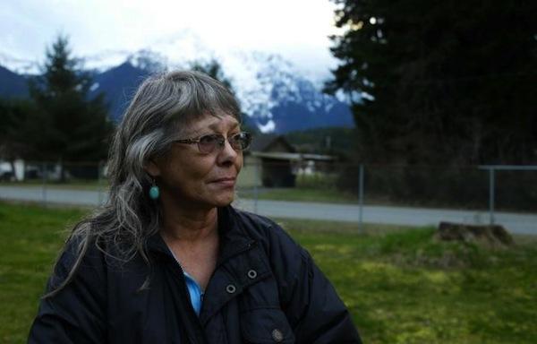
Ted S. Warren, AP Robin Youngblood poses for a photo Thursday, March 27, 2014, with Whitehorse Mountain behind her in Darrington, Wash. Youngblood survived the massive mudslide that hit the nearby community of Oso, Wash. last Saturday, and was rescued by a helicopter as she floated on a piece of a roof.
Wind and rain over the weekend have been hampering recovery efforts in the one-square-mile debris field that used to be Oso, Washington before it was obliterated by March 22’s devastating landslide.
The official count of the dead rose to 18 on Saturday March 29 as more bodies were pulled from the wreckage, but the number of missing was reduced to 30, from 90. One of the confirmed fatalities was 4-month-old Sanoah Violet Huestis, who was being babysat by her grandmother, 45-year-old Christina Jefferds. Jefferds also perished. In all, authorities had confirmed 17 dead by Friday evening March 28, though they had found several others who were not yet added to the total, pending identification.
Robin Tekwelus Youngblood was one of the survivors, though she lost everything except a painting. The Okanagon/Tsalagi woman was sitting in her house with a friend, she told the Associated Press, when she heard a roar that sounded like a crashing airplane, then looked out the window just in time to see a wall of mud hurtling toward her mobile home. Within seconds, it was all over.
“All I could say was ‘Oh my God’ and then it hit us,” she told AP. “Two minutes was the whole thing.”
The force of the slide tore off the roof and shoved her mobile home upward. Youngblood and the friend were able to dig out and waited about an hour for help.
Tribes have rushed in to donate personnel, money and other assistance.
Youngblood, whose Cherokee family helped found the nearby town of Darrington in the early 1900s, is still coming to terms with the devastation. Forced out of their homelands when the Cherokee were relocated to Oklahoma and Arkansas, Youngblood’s family had kept going and moved to Washington, AP said. Youngblood moved back to the area from Hawaii, where she had been living until about two years ago.
“Several times this week I’ve said, ‘I need to go home now,’ ” she said. “Then I realize, there’s no home to go to.”
The cherished painting, named “Wolf Vision,” is of a Cherokee warrior, according to the Seattle Times. It came floating by as she clung to the wreckage of her roof, waiting for rescuers. It now is one of her few remaining possessions.
“I’m grateful to be alive,” Youngblood told AP. “I have no idea how I came out without being crushed from limb to limb.”
TULALIP – On the heels of a large donation made by the Tulalip Tribes to aid victims of the Oso, Washington mudslide, the Tulalip community is organizing additional aid in the form of an Inter-tribal Jam session to raise money for Oso families as they recover from their losses.
Tulalip Tribal member Natosha Gobin, the event’s organizer, explained the proximity of the Oso community to Tulalip created a desire in community members to want to help.
“I had an idea that we could do an inter-tribal jam session where we invite other tribes to our reservation to share songs and prayers while raising money for donations. People have done these in the past, and it has been a positive gathering that uplifts people in a time of heartache. All it took was posting on Facebook to see who would be interested in volunteering for the event, and right away there was enough interest to make it happen.”
The jam session is scheduled for April 4 at 6:00 p.m. at 6700 Totem Beach Road on the Tulalip Reservation. A $5 donation will be accepted at the door and the event will feature a concession stand serving beverages, frybread, spaghetti and hamburger soup as well as baked goods. A raffle with items donated by local tribal artists will also be held during the event.
Proceeds from the event will be given to the victims of the mudslide with portions donated to a variety of local relief groups assisting with the mudslide such as search and rescue crews, fire stations, and animal shelters.
“This is all happening from the community uniting to make it a success. There are volunteers in planning, cooking and baking, as well as manning stations at the event, said Gobin. “This is not just for Tulalip tribal members, this is a community gathering to share in songs and prayers.”
The session will begin with a prayer and Amazing Grace sung by Tulalip artist Cerissa Gobin followed by traditional request for guests who traveled the farthest to sing first.
The donations and support from tribes has been incredible. Many tribes citing personal experience with the tragedy of natural disasters.
“Our prayers and thoughts are with all the families that have been affected by this. One of those that was lost in the landslide was a close friend of mine. This affects everybody, no matter where you are or who you are, as tragedy strikes, we all share together,” said Tulalip Tribes Chairman Mel Sheldon, about the Tulalip Tribes donation.
To date Tulalip donated $100,000 to the Snohomish County Red Cross and $50,000 to the Cascade Valley Hospital Foundation. The Colville Tribe dispatched teams of search and rescue volunteers. Just today, Snoqualmie announced a $275,000 donation to assist.
For more information, or to volunteer at the event, please contact Natosha Gobin at 425-319-4416 or at tagobin@yahoo.com.
Brandi N. Montreuil: 360-913-5402; bmontreuil@tulaliptribes-nsn.gov
DARRINGTON, Washington (Reuters) – Search teams picked through mud-caked debris for a fifth day on Wednesday looking for scores of people still missing in a deadly Washington state landslide, as officials reported finding more bodies while acknowledging that some victims’ remains may never be recovered.
The known death toll stood at 24, with as many as 176 people still unaccounted for near the rural town of Oso, where a rain-soaked hillside collapsed on Saturday and cascaded over a river and a road, engulfing dozens of homes on the opposite bank.
The latest tally did not include an unspecified number of bodies that state police spokesman Bob Calkins said had been found on Wednesday. He declined to give further details.
Earlier in the day, local emergency management officials sought to fend off criticism of property development that was permitted just across the river from the caved-in slope after previous landslides in the area.
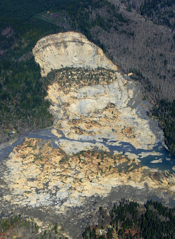
As hope faded that any survivors might be plucked from the muck and debris that blanketed an area covering about one square mile (2.6 square km), residents of the stricken community and nearby towns braced for an expected rise in the casualty count.
“My son’s best friend is out there, missing,” said John Pugh, 47, a National Guardsman who lives in the neighboring village of Darrington. “My daughter’s maid of honor’s parents are missing. It’s raw. And it will be for a long time.”
Asked whether he expected the death toll to rise significantly, Governor Jay Inslee told CNN: “Yes, I don’t think anyone can reach any other conclusion.
“It’s been very sad that we have not been able to find anyone living now for probably 36 or 48 hours,” he said. “The most discouraging thing is we were hopeful that we would find folks who might be protected by a car or a structure, but the force of this landslide just defies imagination.”
About 200 search personnel, many wearing rain gear and hard hats, painstakingly combed through the disaster zone under cloudy skies on Wednesday, taking advantage of a break from Tuesday’s rain showers to hasten their search for more victims.
Snohomish County Battalion Fire Chief Steve Mason, directing part of the operation, said teams were making slow but steady progress in locating additional remains.
“There are finds going on continually. They are finding people now,” he told reporters visiting the search site. “People are under logs, mixed in. It’s a slow process.”
But Jan McClelland, a volunteer firefighter from Darrington who was among the first to arrive at the scene and has spent long days digging through the muck since then, conceded it was possible some bodies may end up forever entombed at the site.
“I’m fearful we won’t find everyone,” she said. “That’s the reality of it.”
NO HUMAN HEAT SOURCES DETECTED
Bill Quistorf, the chief pilot for the county sheriff’s office, recounted that helicopter crews conducting low-altitude scans of the disaster zone with infrared equipment found no human heat sources in the hours after the slide.
“We located one dog in the bushes, and that was it,” he said, also acknowledging that some remains may never be recovered.
At the same time, authorities sought to whittle down their list of unaccounted-for individuals, with missing-persons detectives from the Snohomish County Sheriff’s Office working to resolve likely redundancies on a roster of people whose fate remained unknown.
County officials also started to address criticism for allowing new home construction on parts of the disaster site after a 2006 landslide in the same vicinity, which followed numerous reports detailing the risks of slides dating back to the 1950s.
A 1999 study by geologist Daniel Miller for the U.S. Army Corps of Engineers had warned of the potential for a “large catastrophic failure” in the area, about 55 miles northeast of Seattle.
“There’s definitely a blame-game going on,” Miller told Reuters. “I’ve always thought it’s inappropriate to allow development in flood plains, in areas at risk of landslides, in part because of the danger to human life and also in part because when something happens, even if no one is hurt, public agencies end up coming in to make repairs,” he said.
The county’s emergency management director, John Pennington, told reporters local authorities had spent millions of dollars on work to reduce landslide risks in the area after the 2006 event.
He suggested that while officials and residents were aware of vulnerability to unstable hill slopes, Saturday’s tragedy came out of the blue.
“We really did a great job of mitigating the potential for smaller slides to come in and impact the community,” Pennington said. “So from 2006 to this point, the community did feel safe; they fully understood the risks.”
But he also said: “People knew that this is a landslide-prone area. Sometimes big events just happen. Sometimes large events that nobody sees happen. And this event happened, and I want to find out why. I don’t have those answers right now.”
Search and rescue operations tapered off overnight but ramped up to full strength again at first light on Wednesday. Searchers used dogs to pinpoint possible locations of victims, as well as electronic equipment such as listening devices and cameras capable of probing voids in the debris.
“We’re not backing off. We’re still going at this with all eight cylinders to get everyone out there who is unaccounted for,” local fire chief Travis Hots said.
The presumed tally of dead rose on Tuesday night from 14 to 24 when county officials reported that search crews laboring in a steady drizzle had recovered two more bodies from the disaster zone and located the remains of eight additional victims.
Eight people were injured but survived the slide, including a 22-week-old baby rescued with his mother and listed in critical condition but improving. The mother and three other survivors also remained hospitalized.
The slide already ranks as one of the worst in the United States. In 1969, 150 people were killed in landslides and floods in Virginia, according to the U.S. Geological Survey.
(Additional reporting by Bill Rigby in Seattle, Bryan Cohen in Arlington, Washington, and Dan Whitcomb in Los Angeles; Writing by Steve Gorman; Editing by Cythia Johnston, Dan Grebler and Gunna Dickson)
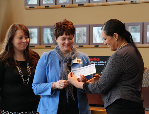
TULALIP – This morning at 10:00 a.m. the Tulalip Tribes Charitable Contributions Fund donated $100,000 to the American Red Cross and $50,000 to the Cascade Valley Hospital Foundation to aid in disaster relief efforts in the Oso community. On Saturday, March 22, a massive landslide swept over houses, SR530, and even the Stilliguamish River. A concerted relief effort by search and rescue teams, fire crews from around the state, the national guard, and numerous other organizations and individual volunteers continues to clear the road, monitor the river, and search for missing people as families and the Oso community cope with grief.
“We at the Cascade Valley Hospital Foundation are so humbled and deeply grateful. Neighbors helping neighbors, and we will help our mutual neighbors as they recover from this devastating loss,” said Heather Logan, Cascade Valley Hospital Representative for the Cascade Valley Hospital Foundation.
Chuck Morrison of the American Red Cross also expressed gratitude, offering a few encouraging words.
Photo/ Brandi N. Montreuil, Tulalip News
“We share a mission of making sure the families of those missing are all taken care of,” he said. “This generous gift from the Tulalips will help us serve the families of the missing victims of this catastrophic mudslide. We appreciate the
Tulalip Tribes vice-chairwoman Deborah Parker presents a donation check in the amount of $50,000 to Heather Logan of the Cascade Valley Hospital Health Foundation. The donation will be used for the Oso, WA mudslide victims’ fund. Photo/ Brandi N. Montreuil, Tulalip News
donations from organizations and individuals across the region and the country to help meet the continuing needs.”
He went on to explain what the funds will do for the relief effort, supplying search and rescue teams and volunteers, as well as immediate assistance for victims of the catastrophe.
Logan spoke about what these funds will do long term, being used for assistance for victims, even to help cover funeral costs.
“We will keep it local, and with zero overhead expenses,” she said.
Tulalip Tribes Chairman Mel Sheldon Jr. said, “Our prayers and thoughts are with all the families that have been affected by this. One of those that was lost in the landslide was a close friend of mine. This affects everybody, no matter where you are or who you are, as tragedy strikes, we all share together.”
Historically, the people of Tulalip have suffered similar catastrophic loss. A landslide in the 1820s on the southern point of Camano Island, known as Camano Head, demolished an historic village site killing all of its inhabitants. The slide sent a tidal wave across to the north tip of Hat Island, devastating that village site as well.
Sheldon said, “We remember, through history, how close that comes to us as we think of our friends in Oso. We share our deep condolences with everyone affected by this tragedy, which is heartfelt throughout our community. We hope this donation will aid people as they grieve and work to rebuild their lives.”
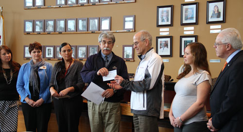
Tulalip Tribes Chairman Mel Sheldon presents a donation check in the amount of $100,000 to Chuck Morrison, regional executive director of the Snohomish County chapter of the American Red Cross. The donation will help assist with shelter, food and basic needs for the survivors and families devastated by the Oso, WA mudslide. Photo/ Brandi N. Montreuil, Tulalip News
Andrew Gobin is a reporter with the See-Yaht-Sub, a publication of the Tulalip Tribes Communications Department. Email: agobin@tulaliptribes-nsn.gov Phone: (360) 716.4188
Seattle Times photo. State allowed logging on plateau above slope This aerial photo, taken after Saturday’s landslide, shows part of the plateau that has been logged over the decades. Right above where the hill fell away is a 7½-acre patch, shaped like a triangle, that was clear-cut about nine years ago.
In recent decades the state allowed logging — with restrictions — on the plateau above the Snohomish County hillside that collapsed in last weekend’s deadly mudslide.
The plateau above the soggy hillside that gave way Saturday has been logged for almost a century, with hundreds of acres of softwoods cut and hauled away, according to state records.
But in recent decades, as the slope has become more unstable, scientists have increasingly challenged the timber harvests, with some even warning of possible calamity.
The state has continued to allow logging on the plateau, although it has imposed restrictions at least twice since the 1980s. The remnant of one clear-cut operation is visible in aerial photographs of Saturday’s monstrous mudslide. A triangle — 7½ acres, the shape of a pie slice — can be seen atop the destruction, its tip just cutting into where the hill collapsed.
Multiple factors can contribute to a slide.
With the hill that caved in over the weekend, geologists have pointed to the Stillaguamish River’s erosion of the hill’s base, or toe.
But logging can also play a role in instigating or intensifying a slide, by increasing the amount of water seeping into an unstable zone, according to an analysis of the watershed submitted to the state Department of Natural Resources (DNR).
In May 1988, when a private landowner, Summit Timber, received approval to begin logging above the slope, scientists raised alarms about the removal of trees that intercept or absorb so much water, according to documents obtained by The Seattle Times.
Paul Kennard, a geologist for the Tulalip Tribes, warned regulators that harvesting holds “the potential for a massive and catastrophic failure of the entire hillslope.”
Others echoed his concerns. Noel Wolff, a hydrologist who worked for the state, wrote that “Timber harvesting could possibly cause what is likely an inevitable event to occur sooner.” And Pat Stevenson, an environmental biologist for the Stillaguamish Tribe, cited “the potential for massive failure,” similar to a slide that occurred in 1967.
The agency that issued the permit — the DNR — responded to the concerns by assembling a team of geologists and hydrologists to study the harvest’s potential impact on landslides.
Lee Benda, a geologist with the University of Washington, wrote a report that said harvesting can increase soil water “on the order of 20 to 35 percent” — with that impact lasting 16 to 27 years, until new trees matured. Benda looked at past slides on the hill and found they occurred within five to 10 years of harvests.
In August 1988, the DNR issued a stop-work order, putting Summit Timber’s logging operation on temporary hold.
“1988 was maybe the first time that we were getting serious as to what you should or should not do in terms of logging and road construction around those things,” said Matt Brunengo, at that time a DNR geologist.
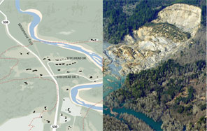
GRAPHIC BY THE SEATTLE TIMES; PHOTO BY TED S. WARREN / AP Use an interactive tool to look at the effects of the mudslide.
A week after the stop-work order, a Summit representative wrote DNR, saying $750,000 to $1 million worth of timber was at stake. He listed alternative steps that could be taken to lessen the risks of a slide — for example, having the state relocate the channel of the Stillaguamish River that was cutting into the hill’s base.
“I can only conclude that the real issue here is not slides and water quality, but timber cutting,” he wrote.
Although records indicate that at least 300 acres were harvested on the plateau in the late 1980s, the state moved to prevent Summit Timber from clear-cutting 48 acres considered most likely to discharge water down the slope.
Mapping out the areas most likely to feed water into unstable terrain is “fraught with uncertainty,” wrote one geologist who studied this landslide zone in the 1990s.
Summit Timber was a family-logging business led by Gary Jones, who grew up in nearby Darrington. Jones believed the acreage atop the hill was second-growth forest, initially logged in the 1920s or 1930s. He said the company eventually backed away from its request to log the 48 acres, given the hill’s history.
“It was a little bit risky,” Jones told The Seattle Times. “We decided not to do it.”
Jones said he was always cautious when working around the river, especially considering he was an avid fly fisherman fond of the Stillaguamish.
Kennard, who now works as a geomorphologist at the National Park Service, said the 1988 application was contentious because the state rarely objected to proposed harvests. Getting the DNR to limit the cut’s scope was no small task, he said.
“That was considered kind of a big victory,” Kennard said.
Concerns about landslides surfaced again in 2004, when property owner Grandy Lake applied for a permit to clear a 15-acre tract near the plateau’s edge.
The state rejected the application, saying some of the proposed logging fell within a sensitive area that could feed water into the slope. Working in that zone would require years of intensive monitoring of precipitation and groundwater.
Grandy Lake revised its application, halving its proposed harvest to avoid the sensitive zone. The final plan — a clear-cut shaped like a right triangle — had an eastern border that abutted the area.
The state approved Grandy Lake’s application while attaching conditions, including: “All yarding and log-hauling activities will cease at the onset of heavy or steady rain and will not resume until the rain has subsided for at least 24 hours.”
Harvesting in that area was finished by August 2005.
Officials with Grandy Lake did not return calls seeking comment Tuesday.
In January 2006, a large slide hit, with so much mud crashing into the Stillaguamish that the river was diverted. Where the hill fell away was maybe 600 feet southwest of the clear-cut area.
Saturday’s slide took more of the hill, reaching right up to that triangle.
Grandy Lake has done selective logging on the plateau in more recent years. Following the approval of a 2009 permit that also included an area abutting the sensitive zone, the company reported to the state that it removed 20 percent of the area’s trees. It returned in 2011 and got approval to take 15 percent more.
Staff reporter Justin Mayo contributed to this report. Mike Baker: mbaker@seattletimes.com or 206-464-2729; Ken Armstrong: karmstrong@seattletimes.com or 206-464-3730
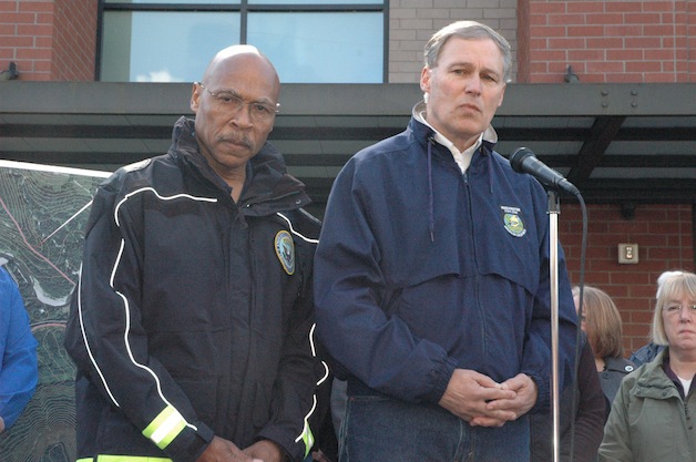
Snohomish County Executive John Lovick, left, and Washington state Gov. Jay Inslee address the news media at the Arlington Police Station on March 23 about the Oso landslide on March 22. — image credit: Kirk Boxleitner
Kirk Boxleitner, Arlington Times
ARLINGTON — Washington state Gov. Jay Inslee joined fellow elected officials from the federal to the local levels at the Arlington Police Station on Sunday, March 23, to address the landslide in Oso on Saturday, March 22, that’s since blocked both State Route 530 and the North Fork of the Stillaguamish River, even as the surrounding community continues to respond in its own ways.
“We always plan for things that we hope will never happen,” said Snohomish County Executive John Lovick, before he introduced not only Inslee, but also U.S. Sen. Patty Murray and U.S. Rep. Susan DelBene. “This is an example of how we have planned, and why it is so wonderful that we have such a great, functioning government in not only Washington state, but also Snohomish County.”
“Olympia is the state capitol of Washington, but today, Oso is the heart of the state of Washington,” Inslee said. “It is a small community of only 200-plus people, but there are six and a half million Washingtonians who, at this moment, are embracing them with our arms and our prayers.”
Inslee called upon his fellow Washington residents to extend aid to a community that had previously managed to remain self-sufficient in relative isolation. Although he was pleased to confirm that at least seven people had been rescued from the site to date, he was nonetheless struck by the scope of the landslide’s impact while flying over the area only an hour before.
“The devastation is just unrelenting and awesome,” Inslee said of the landslide, whose confirmed death toll stands at four so far. “There really is no stick standing in the path of the slide, and it is a reminder that we live in powerful forces of nature, but there is another powerful force of nature, and that is empathy, and compassion, and helping these families who are both grieving and now awaiting words of their loved ones.”
Inslee twice declined to offer any predictions as to when State Route 530 might reopen, but repeatedly pledged that the currently ongoing search and rescue efforts would continue.
“All possible assets that could be beneficial, anywhere, have been brought to bear in this, both from the air and on the ground,” said Inslee, who noted that those assets include both helicopters and hovercraft.
Although the Snohomish County Department of Emergency Management lifted its evacuation order, Inslee asked those downstream of the landslide on the Stillaguamish River to retain “a heightened state of awareness,” advice that was later echoed by Chad Buechler, an American Red Cross volunteer at Post Middle School, which housed 27 overnight occupants from the evening of March 22 through the morning of March 23.
Murray echoed Inslee’s sympathies for both the victims of the landslide and their surviving loved ones, before she commended the first responders to this disaster for their efforts.
“The response to this has been incredible,” Murray said. “People are putting their own lives at risk in the search and rescue efforts. Every single person in these communities — local, state, federal — has been working really hard to make sure that they could do everything they can in this incident.”
Murray pledged that needed federal resources will be made available, and was joined by DelBene in praising Arlington Mayor Barbara Tolbert for her role in supporting those impacted by the landslide.
“She told me this morning that the donations have been incredible,” Murray said of Tolbert. “She said, ‘Please, if you want to help, give donations to the Red Cross directly.’ Monetary donations are what they can really use at this point.”
DelBene extended her thanks not only to Tolbert and the first responders, but also to Darrington Mayor Dan Rankin, whose town she noted has been further isolated by the closure of State Route 530.
In the wake of Washington state declaring a State of Emergency on the evening on March 22, Inslee and other state officials have been in talks with FEMA, and have pushed for a federal declaration of the same, primarily for financial reasons.
“The good news is, we have all of the available assets we really could use right now,” Inslee said. “There is really no missing piece in this rescue effort that we could use that we don’t have. Every single helicopter, every single hovercraft, every single person, every communication system […] we have a full retinue of rescue efforts underway right now. It’s not dependent on the federal financial aspect of this.”
Inslee nonetheless expects those federal dollars to become important down the line, especially given the anticipated expenses of reconstructing the extensively damaged State Route 530.
“Mother Nature holds the cards here, on the ability of ground personnel to enter the slide area,” Inslee said, when asked about the limits imposed on search and rescue personnel by what he described as “essentially a slurry.” “Some of them went in, literally got caught up to their armpits and had to be dragged out by ropes themselves, so they have taken risks already. It’s just the physical impossibility of supporting the human weight in a slurry that is the problem right now.”
At the same time, Inslee reassured the families and friends of the 18 people who remain unaccounted for, “Every human possibility is being explored here, to rescue and find their loved ones.”
Up the hill from the Arlington Police Station, Buechler estimated that as many as a couple of hundred visitors had filtered through Post Middle School on March 22, to utilize the on-site crew of mass care personnel, mental health professionals and nurses, as Red Cross volunteers have kept in constant contact with local fire and emergency medical services personnel.
“Some of them just wanted to get information, and that’s okay,” Buechler said. “We want people to know that this is a place that they can go for support if they’ve been affected by the landslide, whether they’ve been displaced by it, or they need to talk to someone about it, or they just need someone to share some info.”
While Buechler urged folks to stay safe, by monitoring the situation through the news on their radios or smart-phones, measures have been taken to keep people safe, including the closure of the Twin Rivers and Haller parks. Just up the road from Haller Park, the Food Pavilion at 146 E. Haller Ave. in Arlington became a collection site for food, water and hygiene supplies starting on March 23.
“I heard what was going on, so I had to do something,” said Kara Brown, who’s friends with Arlington Food Pavilion Store Manager Loly Ramirez.
Brown and her husband Mike were joined by Ramirez and her daughter Erica, who kicked off their donation drive at 10 a.m. on March 23, and had already filled half their trailer and collected an estimated $800 in cash by 1 p.m. that same day.
“We had cars lined up at the hospital last night, wanting to drop off donations for those in need,” said Jennifer Egger, community relations coordinator for Cascade Valley Hospital, as she stopped by the Food Pavilion on March 23. “Now, we’re just directing them all here.”
“This has been greatly upsetting to us, not in the least because many of these people are our customers,” Ramirez said. “We don’t even know yet whether some of our customers might be among the missing, so we really appreciate the support and generosity that this community is showing for its own. It’s amazing to see so many people pulling together in times like these.”
Egger expressed a similar measure of pride in Cascade Valley Hospital’s response to this situation, citing its capable handling of the six patients who came to them as the result of exhaustive emergency training by hospital staff.
“One of those patients is still in-house with us,” Egger said. “It’s been so sad for everyone.”
The Arlington Food Pavilion will continue to collect cash and supplies throughout the week, during normal store hours, for those affected by the landslide.
Search operations by air resumed at first light on March 23, with two helicopters from the Snohomish County Sheriff’s Office surveying and mapping the site.
According to Shari Ireton, director of communications for the Snohomish County Sheriff’s Office, ground rescue operations remain extremely hazardous due to the debris field, which has been described by rescuers as possessing a “quicksand-like consistency.” Crews are attempting to reach the affected area from both the west side in Oso and the east side in Darrington.
Ireton declined to estimate the total number of people displaced by the landslide, but she predicted that the Snohomish County Department of Emergency Management would reinstate its evacuation order during the evening of March 23.
Those who wish to help are being asked to donate to the Red Cross by texting “90999.” Those with questions about reunions with family members who may be missing, as well as about evacuation or shelter information, should call 425-388-5088.
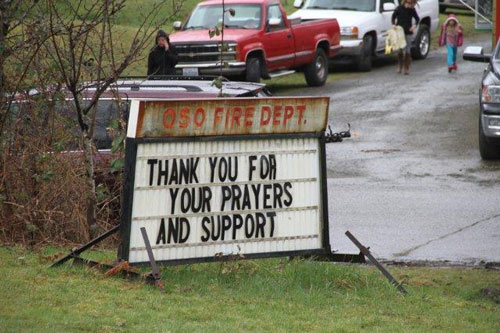
State Route 530 remains closed from the Oso Fire Department, located at 21824 SR 530, on the west side of the landslide, and from Little French Creek Road, located at milepost 42, on the east side of the landslide.