Depaving Cities, Undamming Rivers—Here’s How We’re Undoing the Damage

All around the United States, people are stepping up to help a damaged planet heal.

Remains of the Glines Canyon Dam on the upper Elwha River. Photo by James Wengler.


By Diane Brooks, Yes! Magazine

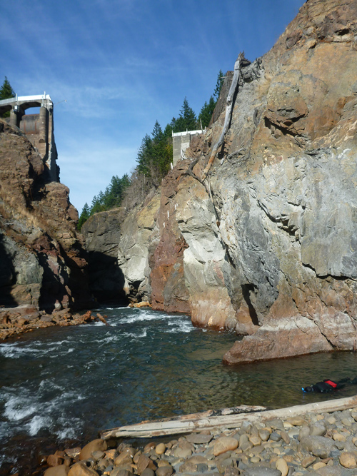
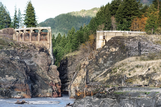
Releasing the rivers

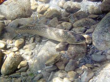
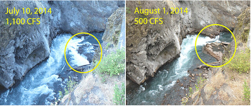
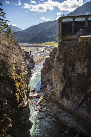
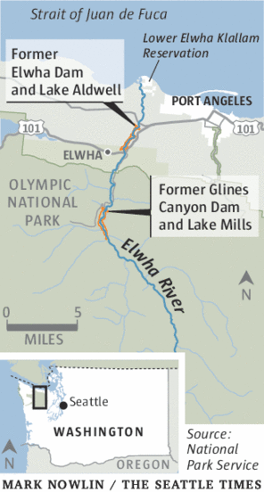
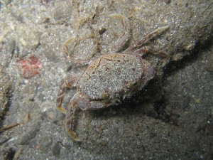
The largest dam-removal project in history reached completion last fall, when excavators dredged the final tons of pulverized concrete from the Elwha River channel in Western Washington. Native fish, banished for 100 years from their historic spawning habitat, already were rediscovering the Elwha’s newly accessible upper stretches. Within weeks of the final explosion in August, threatened bull trout and chinook salmon were spotted migrating beyond the rubble.

“It was a thrill,” said Olympic National Park spokeswoman Barb Maynes. Before the Elwha Dam was built in 1910, the river produced an estimated 400,000 fingerlings per year, a number that dwindled to 3,000 in recent decades. All five native species of Elwha salmon are expected to repopulate the river.

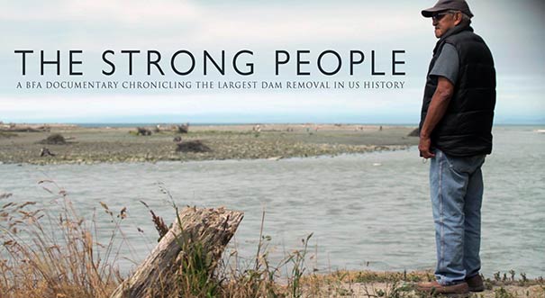
More than 80,000 dams more than six feet high block U.S. waterways, and activists are cheered by the Elwha success story. Two hydroelectric dams once blocked the Elwha; both now are gone. Sediment that was trapped behind them is washing downstream, replenishing habitat. The first 67,000 seedlings (of a planned 350,000) to help restore native vegetation are already planted on the sites of the former dams and reservoirs. A documentary about the project, Return of the River, came out in 2014.


 Photo by Shutterstock.

Botanical remedies

Headache or back pain? Before you reach for the bottle of aspirin, consider aspirin’s ancient precursor: white willow bark. Or perhaps echinacea to boost the immune system, aloe vera to heal burns, and black cohosh to ease hot flashes.

The trend away from the profit-based pharmaceutical industry toward natural, age-old botanical remedies is beneficial for the environment and wildlife as well as for the humans who take medications. A U.S. Geological Survey study found chemicals from prescription drugs and over-the-counter medications in 80 percent of water samples drawn from streams in 30 states; those waters flow into lakes, rivers, and eventually the oceans.

Alain Touwaide, co-founder of the Institute for the Preservation of Medical Traditions, says pharmaceutical chemists have inverted humanity’s relationship with medicines. “When a sick person used a plant, this person relied on history, the use of the plant over centuries,” he says. Now a researcher starts with a chemical and then experiments to find its uses. Botanical medicine has “an almost philosophical component,” he says, which helps with healing. Users tap into an interactive “sympathy” between humans and the environment, he says.


 Photo by Paul Dunn.

Citizen turtle remedies

When a community of threatened Hawaiian green sea turtles began hauling themselves from the ocean onto the northern beaches of Oahu to bask and sleep in the sunshine, word soon spread through the island’s tourism industry. Families began plopping children on turtles’ backs for photos and poking, prodding, and pushing turtles back into the surf.

Concerned, the national Oceanic and atmospheric administration (NOAA) launched a “Show Turtles Aloha” campaign in 2005. North Shore residents quickly joined in, and in 2007 they created the nonprofit Malama na Honu (Protect the Turtles) to monitor the beach and educate visitors every day of the year. About 60 trained Honu Guardian volunteers take turns patrolling Laniakea Beach, working three-hour daylight shifts. They educate tourists about the ancient species, ask beachgoers to keep a respectful distance, and collect data for NOAA.

Hawaiian green turtles were listed as a threatened species under the Endangered Species Act in 1978. They’ve made a remarkable recovery since then, and their major nesting beach at French Frigate Shoals was added to the Papahānaumokuākea Marine National Monument in 2006. The number of nesting turtles has grown annually from 67 in the early 1980s to more than 800 today, according to Irene Kelly, NOAA’s regional sea turtle recovery coordinator.


 Dennis McClung stands inside what used to be a swimming pool in his backyard in Mesa, Arizona. Now it serves as a closed-loop food-producing farm for his family. Photo by Laura Segall.

Swimming pool becomes backyard farm

It’s a typical Mesa, Arizona, suburban subdivision, except for that corner house with a broccoli patch growing on its low-pitched roof. And those goats, chickens, and ducks roaming the backyard, near the solar panels erected above the entryway to that greenhouse planted in the deep end of an old swimming pool. When Dennis and Danielle McClung bought their ‘60s-era home in 2009, they hatched an eccentric but modest plan to make the best of that decrepit, way-past-its-prime pool. Two days after they moved in, Dennis McClung erected his first in-pool greenhouse, intended to provide food for their young family. He had recently quit his job as a Home Depot department manager; his wife was a nurse. “I convinced my wife of my crazy plan, and she went with it,” he says. “We really wanted to live a more sustainable, self-sufficient life, and we thought this was good idea. And it just kept getting better and better, the more we put into it.”

Today their backyard is a mini-ecosystem—McClung calls it a “closed-loop food-producing urban greenhouse”—and their home is headquarters for the Garden Pool nonprofit organization. Its official aim: sustainable food production, research, and education. At night the chickens roost above the pool’s deep-end rainwater pond so their droppings contribute to an aquaponics habitat for tilapia fish. The McClung’s natural water filtration system uses duckweed and solar energy; their organic greenhouse plants are rooted hydroponically, without soil. Pond snails, which probably hitchhiked in on the duckweed, provide calcium for the egg-laying chickens and help manage a pond-sludge problem.

On a typical day, the system provides the couple and their three children with about half their diet, McClung says. That includes veggies and herbs from the greenhouse; apples, citrus fruit, figs, sugar cane, bananas, and pomegranates picked from a 40-tree grove in their side yard; along with eggs and goat milk.


Making room for carnivores

When gray wolves were reintroduced to Yellowstone National Park in the mid-1990s, we learned valuable lessons about the critical role of large carnivores in balancing an ecosystem. The impact on the landscape was dramatic. Two decades later, stream banks stripped by booming populations of deer and elk are growing new trees and shrubs, and birds and beavers are returning to the feast. Even the physical landscape has been altered, as returning vegetation stabilizes banks and prevents erosion.

Now a growing movement of scientists and conservationists is campaigning to go further to ensure the health and survival of large carnivores: defining and protecting ancient migration corridors across the continent. a key component of this campaign is educating affected communities about the importance—and practicality—of coexisting with species that traditionally were feared and killed.

In her new book The Carnivore Way: A Transboundary Conservation Vision, Cristina Eisenberg says coexistence with wild predators isn’t just possible: it’s critical. “Carnivores protect biodiversity, which creates ecosystems more resilient to climate change. The climate change crisis we are facing makes it critical for us to help carnivores thrive wherever we can,” says Eisenberg, lead scientist at Earthwatch Institute.

The Wildlands Network has identified two initial priorities for protection. The Eastern Wildway runs 2,500 miles from Florida’s Everglades through the forests of Alabama and along the Appalachian Mountains to the boreal forests and Maritime Provinces of Canada. The Western Wildway is a 5,000-mile corridor stretching from Mexico’s Sierra Madre Occidental to Alaska’s Brooks Range, running along the Rocky Mountains.


 Photo from Depave.

Asphalt, be gone

Across the nation, activists are organizing work parties to rip up excess pavement in playgrounds, parking lots, and empty lots, replacing it with pervious surfaces such as porous asphalt, block pavers, and greenery of all sorts. The swaths of impervious pavement that characterize our urban and suburban communities, from sprawling shopping malls to ubiquitous cul-de-sac neighborhoods, have vast ecological impacts. Rainwater—which otherwise would soak into the earth and benefit the habitat—is polluted with oil, antifreeze, and pesticides and then diverted into local streams and rivers.

The Portland, Oregon, nonprofit Depave promotes the transformation of over-paved places, such as schools, while engaging and inspiring communities to reconnect urban landscapes to nature. The organization uses community partnerships and volunteer power, and creates educational events, to pursue its goal of nurturing livable cities where people and wildlife can coexist. Since its initial project in 2008, Depave has transformed more than 123,000 square feet of asphalt, diverting about 2.9 million gallons of stormwater from storm drains. Above, the Creston School depaving project last fall.


 Photo from Rebuild by Design.

Rebuild smarter

The devastation wrought in 2012 by Hurricane Sandy, including 117 U.S. deaths and an estimated $5 billion in damages to greater New York alone, shocked planners and policymakers into fashioning innovative new tactics to protect communities from future disasters. Rebuild by Design, a unique public-private partnership, is identifying and funding ambitious, creative infrastructure improvements in New York, New Jersey, and Connecticut. A contest initiated by the U.S. government already has allotted $930 million to six winning projects, each crafted with powerful community input.

“Sandy exposed physical and social vulnerabilities of the region. It was not built to withstand the forces of climate change, and now we can rebuild it with better foresight,” said Amy Chester, Rebuild by Design’s managing director.

Major philanthropic partners staffed the U.S. Department of Housing and Urban Development contest, and the project is funded by Congress, along with the Rockefeller Foundation and other private supporters. Design teams worked closely with local residents, businesses, and governments to codesign realistic solutions that carry broad support, Chester said.

In Manhattan, for instance, the community examined how river berms can benefit daily public life. “A wall can be a piece of art; a wall can be a part of a park. A wall should never be something that walls off the communities from the waterfront,” said Chester. One winning proposal: the Big U river fortifications. A 10-mile stretch of Lower Manhattan is to be protected from future storms and rising sea levels with projects including wide, grass-topped berms and rolling hills and bridges, providing new recreational spaces along the Hudson and East rivers.

Lower Elwha Tribe studies wood movement in Elwha River


By: Northwest Indian Fisheries Commission

The Lower Elwha Klallam Tribe is tagging large woody debris to follow it as it moves through the newly restored Elwha River system.

“We’re tracking over 2,000 logs and tree stumps with silver tree tags, from the upstream end of Lake Mills to the river mouth,” said Vivian Leung, a doctoral student of geomorphology at University of Washington.

She’s been working with the tribe since 2012 to study how large wood debris (LWD) has affected the river during and after the removal of the river’s two-fish blocking dams.

“Not only did the dams completely block the supply of sediment downstream, but they also altered the transportation of large wood,” said Mike McHenry, the tribe’s habitat manager. “Both elements are critical for habitat forming processes not only in the river but in the nearshore. The fate of wood is relevant to the recovery of the river and its aquatic resources, especially salmon.”


Silver tags are attached to log and stumps throughout the Elwha River so scientists can track their movements as the river changes during restoration.

Silver tags are attached to log and stumps throughout the Elwha River so scientists can track their movements as the river changes during restoration.


As the dams came down, the lake Aldwell and Mills reservoirs were drained, leaving behind thousands of logs and tree stumps that had been buried under sediment and water for the past century. The natural action of the river is transporting the logs and stumps throughout the new riverbed, changing the dynamics of the river and creating better salmon habitat.

Leung is interested in how logjams form and affect channel patterns, how wood is transported through rivers and how the pools they create provide places for salmon to rest, feed and spawn.

“Surprisingly, there’s still a lot of research to be done to understand how large wood debris interacts with river systems,” she said. “So far we have found that logjams and salmon habitat are forming significantly faster in Aldwell than we expected.”

The large logs and rootwads also are aiding revegetation efforts of the lakebeds. The tribe hired a heavy-lift helicopter recently to relocate 500 unmarked logs around Mills. The logs were moved from the former reservoir pool elevation to terraces along the river’s floodplain.

These logs are expected to help stabilize steep slopes and provide sheltered areas for young plants to survive during planned revegetation efforts in the coming years, McHenry said. During 2014-2015, 100,000 woody plants will be planted into the former Mills reservoir surface.

Three Chinook Spotted Above Glines Canyon; First Salmon Return to the Upper Elwha in 102 Years

A member of the Olympic National Park fisheries team snorkels just above the remnants of Glines Canyon Dam.  Three Chinook salmon were sighted during a snorkel survey this week.NPS photo
A member of the Olympic National Park fisheries team snorkels just above the remnants of Glines Canyon Dam. Three Chinook salmon were sighted during a snorkel survey this week.
NPS photo


National Park Service News Release


Following an observation by a fisheries biologist and member of the Lower Elwha Klallam Tribe of a possible Chinook salmon in the former Lake Mills, two Olympic National Park fisheries staff conducted a snorkel survey of the Elwha River above the old Glines Canyon dam site.

They found three adult Chinook salmon, all between 30 and 36 inches long, in the former Lake Mills, between Windy Arm and Glines Canyon.  Two fish were seen resting near submerged stumps of ancient trees;the third was found in a deep pool in the former Lake Mills.

“When dam removal began three years ago, Chinook salmon were blocked far downstream by the Elwha Dam,” said Olympic National Park Superintendent Sarah Creachbaum. “Today, we celebrate the return of Chinook to the upper Elwha River for the first time in over a century.”

“Thanks to the persistence and hard work of many National Park Service employees, the Lower Elwha Klallam Tribe and many other partners, salmon can once again reach the pristine Elwha watershed within Olympic National Park,” said Creachbaum.

In addition to the three Chinook, biologists counted 27 bull trout, nearly 400 rainbow trout and two small sculpin during their survey above Glines Canyon.

The biologists began their snorkel survey in Rica Canyon three miles above the old Glines Canyon dam site. They then snorkeled downstream through the Canyon, through the former Lake Mills and downstream to a point just above Glines Canyon.

Last week, park biologists confirmed that two radiotagged bull trout had migrated through Glines Canyon and were in Rica Canyon. The three Chinook observed this week were not radiotagged, but were seen by observers on the riverbank and in the water.

The following day, biologists counted 432 live Chinook in a 1.75 mile section of river just downstream of Glines Canyon, but still above the old Elwha dam site.

Elwha River Restoration is a National Park Service project that includes the largest dam removal in history, restoration of the Elwha River watershed, its native anadromous fisheries and the natural downstream transport of sediment and woody debris.  For more information about this multi-faceted project, people can visit the Olympic National Park website at http://www.nps.gov/olym/naturescience/elwha-ecosystem-restoration.htm.

Fish migrate into upper Elwha River for first time in century

fish_elwha


By Leah Leach, Peninsula Daily News


OLYMPIC NATIONAL PARK — Fish have migrated into the upper Elwha River for the first time in a century.

Olympic National Park biologists confirmed last week that two radio-tagged bull trout had migrated from the lower river through the former area of Glines Canyon Dam and reached at least as far as Rica Canyon above the former Lake Mills, some 15½ miles from the mouth of the Elwha River.

Four bull trout had been detected earlier as they passed a telemetry station upriver from the former Glines dam.

Thursday’s walk along the river with handheld radio receivers confirmed it wasn’t a faulty signal, at least for Fish 167 and Fish 200.

“The fish have made it” for the first time in 100 years, spokeswoman Barb Maynes said Friday.

Clearing the river for migratory fish passage was the point behind the $325 million Elwha River restoration project that began in 2011.

Both Elwha Dam, built in 1912 about 5 miles from the river’s mouth, and Glines Canyon Dam, constructed in 1927 some 13 miles from the mouth, were made without fish ladders and so blocked migrating salmonid passage from a river once known for legendary salmon runs.

The 108-foot Elwha Dam was demolished by March 2012.

The last 30 feet of the once-210-foot-tall Glines Canyon Dam came down Aug. 26.

The passage of four radio-tagged bull trout was detected even before that final blast, Maynes said.

That was possible because the 30-foot stub of the dam did not extend all the way across the river channel.

Park biologists know a great deal about those two fish — and hope to know more soon.

Fish 167 was captured and radio-tagged May 7 about 3.5 miles above the river’s mouth. It was 19 inches long.

This bull trout swam through the old Elwha dam site in late July before being noted again 8 miles upriver in early August.

Fish 200, measuring 20.5 inches, was radio-tagged June 25 about a mile and a half upstream of the river’s mouth.

It swam past the Elwha Dam site July 20 and swam through Glines Canyon on Aug. 24, just before the final blast.

Did the bull trout originate in the Elwha River?

Researchers don’t know yet, Maynes said, but they plan to perform genetic tests on fin clips taken when the fish were radio-tagged.

Those tests, which so far as Maynes knows haven’t been scheduled yet, would tell biologists the origin for the fish, she said.

Bull trout in the Olympics often get around, according to the U.S. Fish and Wildlife Service.

Bull trout, which were listed in 1999 as a threatened species under the Endangered Species Act, may live near areas where they were spawned or migrate from small streams to larger streams and rivers or from streams to lakes, reservoirs or salt water, according to the agency.

In a May 2004 draft recovery plan, the agency said bull trout populations within the Olympic Peninsula Management Unit “exhibit all known migratory life history forms of this species, including fluvial [fish that migrate from tributaries to larger rivers to mature], adfluvial [fish that migrate from tributaries to lakes or reservoirs to mature], and anadromous [fish born in fresh water that migrate to the ocean to grow and live as an adult, returning to fresh water to spawn] populations.”

Biologists will continue to look for signs of migrating fish in the upper parts of the 42-mile river, which with its tributaries offers more than 70 miles of fish habitat.

Eighty-seven fish have been radio-tagged so far, Maynes said.

Of that, 13 bull trout, two winter steelhead, five chinook and one sockeye salmon have been located above the old Elwha Dam site.

Each fish is equipped with a uniquely coded radio transmitter that differentiates it from all other tagged fish.

Radio signals from the tags are then detected by radio receivers and antennas.

Six telemetry stations were installed between the mouth of the river and just above the Glines Canyon Dam site.

These stations continually scan for and record data, documenting when individual fish pass by each station.

Biologists also manually track fish between Rica Canyon and the river mouth using handheld radio receivers and antennas.

Also involved in the radio-tracking program are biologists with the Lower Elwha Klallam tribe and U.S. Fish and Wildlife Service. Washington’s National Park Fund has provided funding, Maynes said.

For more information, visit http://tinyurl.com/PDN-damremovalblog.

A Visit To The Largest Elwha River Dam In Its Final Moments

By: Ashley Ahearn, OPB


PORT ANGELES, Wash. — The National Park Service is in the final phase of the largest dam removal in U.S. history, taking place on the Olympic Peninsula.

Just 30 feet of concrete dam stand between the Elwha River and its freedom.

And early next week, it’ll be gone.

A giant orange crane moves slowly overhead as Don LaFord looks down from a narrow walkway over the Elwha River.

LaFord, a contractor for the National Park Service, has overseen the dam removal project from the beginning in 2011. Two hundred feet below where he’s standing, the river rushes by, almost completely free. Almost.

“It’ll be a final dynamite shot,” LaFord says.

Don LaFord
Don LaFord. Credit: Ashley Ahearn


So far, a little more than half of the millions of tons of muck and debris that were lodged above this dam have been released, turning the river a chalky gray color as it empties into the Strait of Juan de Fuca, 13 miles from where we’re standing.

“I spent most of my career building power plants and this is the first one that I’ve been on where we’re demolishing hydroelectric plants,” LaFord said.

When the dams are gone he says he might retire.

Although the dam removal workers will soon be departing, fish and wildlife are doing no such thing. Salmon, otters and bald eagles are arriving upstream from where the dams blocked the flow of this river for more than 100 years.

The park service plans to have walkways installed so the public can see the former Glines Canyon and Lower Elwha dam sites in the next few months.

Screen shot 2014-08-21 at 7.50.41 PM
These two images show the difference in the Elwha River’s flow from July 10 to August 1. The remaining dam is circled in yellow in each image. Now that flows have dropped enough to expose the concrete, dam removal can begin again. Credit: National Park Service.

Back to nature: Last chunk of Elwha dams out in September

Steve Ringman / The Seattle TimesWhat’s left of the 210-foot-high Glines Canyon Dam, a section of about 30 feet, is awaiting a final blast in September. In the distance, the bottom of former Lake Mills today forms part of the new Elwha Valley.
Steve Ringman / The Seattle Times
What’s left of the 210-foot-high Glines Canyon Dam, a section of about 30 feet, is awaiting a final blast in September. In the distance, the bottom of former Lake Mills today forms part of the new Elwha Valley.


Fish are storming back to the Elwha, there’s a sandy beach at the mouth of the river again, and native plants are growing where there used to be lakes.


By: Lynda V. Mapes, Seattle Times

The last dam will be blasted out of the Elwha River sometime next month, cementing the hopes of generations of advocates and tribal leaders who fought to make it happen.

With the concrete out, the long-term revival of a legendary wilderness valley in the Olympics can now unfold unfettered after 100 years dammed.

The watershed already is springing back to life from the mountains to the sea: Salmon are swimming and spawning miles above the former Elwha dam site. Alders stand more than head high as the native forest reclaims the former lake beds. There’s a soft, sandy beach at the river mouth, where before there was only bare cobble. And birds, bugs and mammals are feasting on salmon eggs and carcasses as fish once again nourish the watershed.

The Elwha is a rare chance to start over on a grand scale. The $325 million federal project, begun three years ago, has reopened 70 miles of habitat for steelhead and salmon, rebuilt wildlife populations and restored native plants. The river is hard at work with its restored natural flow, rebuilding its plunge pools, log jams and gravel bars.

While it will never be the Eden it was, the Elwha one day likely will be pretty darn close — and sooner than many expected.

“It goes against my deepest notions of how fast ecosystem recovery can possibly happen,” said Christopher Tonra, a research fellow with the Smithsonian Migratory Bird Center in Washington, D.C., who is tracking the response of dippers, a native, aquatic songbird, to dam removal in the Elwha. “We are all trained, as biologists, to think of things over the long run. I am not saying the Elwha is fully recovered. But it is so mind blowing to me, the numbers of fish, and seeing the birds respond immediately to the salmon being there. It makes the hairs on the back of my neck stand up.”

Early hydropower

The dams were built beginning in 1910 for hydropower, but lacked fish passage. It took an act of Congress, passed in 1992, to finally take down Elwha Dam and then Glines Canyon Dam, about eight miles above it.

Unbuild it, and they will come: Salmon have been storming back ever since Elwha Dam was blasted out of the way in March 2012. Taking down Glines Canyon Dam has taken longer, in part because it holds back a larger load of sediment.

Managing the release of about 27 million cubic yards of sediment as the dams come down is why removal has taken so long. There was so much sediment stuck behind the former Glines Canyon Dam alone that, stacked up, the pile would tower more than twice the height of the Empire State Building, notes Jonathan Warrick, of the U.S. Geological Survey.

The dams were lowered notch by notch, allowing the river to naturally flush about half the total sediment load downriver and out to the Strait of Juan de Fuca.

There have been bumps along the way. A water-treatment plant — the single most expensive part of the project — failed when a critical intake clogged with debris rinsed out by the river, delaying removal by a year while repairs were made.

The tribal hatchery and federal fish-restoration plan, which includes stocking of some hatchery fish, have been a magnet for lawsuits and controversy.

But nature, meanwhile, has carried right on.

Ian Miller, a coastal hazard specialist based in Port Angeles for Washington Sea Grant, has been monitoring the beach at the river mouth.

The surprise to him isn’t the big volume of sediment the Elwha is delivering downstream, but the fact that it is sticking around. “Basically, this is all new land,” Miller said, walking the beach east of the river mouth on a recent visit. “Everything here is less than two years old. You can walk to (sandy) spots on the beach that are 30 feet deep. It is just a dramatically different system.”

A beach that used to be too rocky to comfortably walk on is today used by kids to play soccer.

Meanwhile, fat chinook salmon are cruising up the river. Staff from the Washington Department of Fish and Wildlife started working the Elwha in July with a gill net to eventually capture 1,600 big Elwha fall chinook. The fish, of both wild and hatchery origin, are taken to stock the next generation of Elwha fall chinook raised in the state rearing channel, used since the 1970s to preserve the unique Elwha strain.

2024327957

Stars of the river

Working the fast current was a fish rodeo to capture, then quickly take the powerful, thrashing fish from the net unharmed. Long and thick as a thigh, the chinook, the largest in the Puget Sound region, are the celebrities of Elwha River restoration, and a major reason for dam removal.

Elwha fish populations are projected to grow from about 4,000 to 400,000 over the next 20 to 30 years. Salmon already have hatched and migrated up- and downstream of the former Elwha dam site for the first time in a century.

Revegetation — the most visible piece of the Elwha renewal project — also is unfolding dramatically. Already, terraced banks of the former lakes are burgeoning with alder and cottonwood, the gift of seeds carried by the lakes as they gradually were lowered during the drawdown that started dam removal.

Most difficult to revegetate are the cobbly, gravel flats of the lake bed farther upstream, in the former Lake Mills, a land where many a planted Douglas fir and other seedlings have gone to die.

But in other spots, cottonwood seedlings have established so thickly they look like a lawn. Alder trees seeded in 2011 as lake levels dropped now have grown more than head tall. Where there used to be bald sand, goldenrod buzzes with bees, and a young, stocky Nootka rose bush conceals a bird’s nest full of eggs.

In all, more than 500 acres of former lake bed are being replanted, with nearly 60 varieties of native grasses, flowers, woody shrubs and trees from the Elwha Valley through 2018.

Dam removal also is kick-starting broader effects in the ecological systems of the watershed, from its food chain to the home ranges of animals.

Kim Sager-Fradkin, wildlife biologist for the Lower Elwha Klallam Tribe, already has tracked fish-eating otters to parts of the Elwha that salmon have recolonized since dam removal, and documented an increase in the otters’ nutrient levels derived from fish.

John McMillan, a biologist with National Oceanic and Atmospheric Administration (NOAA) Fisheries walking the tributaries since dam removal began, said that in the first year he saw salmon carcasses on the riverbank. But now he doesn’t because the otters, bears, cougars, bobcats and mink have learned to take advantage of food where for so many years there was none.

“The ecological relationships between the animals are coming back,” McMillan said. To me, that is such a great feeling.”


Walk the river

Take a walking tour of the Elwha River with Park Service rangers on the former Lake Aldwell. Tours are on Tuesdays and Sundays at 1 p.m. through Sept. 2. The hourlong walks are free, and begin at the former boat launch at the end of Lake Aldwell Road, north off of Highway 101 just west of the Elwha River Bridge. For more information, call 360-565-3130.

Elwha River documentary set to be screened in Port Angeles on Sunday

By Peninsula Daily News staff

the strong people_elwha


PORT ANGELES — “The Strong People,” an award-winning documentary chronicling the Elwha River dam removals west of Port Angeles, is coming to the Elwha Klallam Heritage Training Center, 401 E. First St., at 11 a.m. Sunday (Aug. 3).

Filmmakers Heather Hoglund and Matt Lowe will be in attendance.

The filmmakers are suggesting a $3 donation to recoup travel and screening fees.

Told through the eyes of the Lower Elwha Klallam tribe, “The Strong People” examines the restoration of the Elwha River as two dams are removed, depicting the project’s environmental repercussions and its effects on the tribe.

To explore the range of consequences of the Elwha River dams’ presence and removal, Hoglund and Lowe interviewed tribal members to learn about the importance of the Elwha and its salmon.

For more information, visit www.thestrongpeople.com.

New Sand Habitat Attracting More Life near Elwha River

A juvenile dungeness crab found within the newly formed beaches near the mouth of the Elwha River. Steve Rubin/USGS


Source: Northwest Indian Fisheries Commission

With thousands of cubic yards of sediment forming new beaches at the mouth of the Elwha River, marine life that’s been missing for decades is showing up again.

Before the recent deconstruction of the Elwha and Glines Canyon dams, the beaches at the mouth of the river were mostly cobblestone, which is suitable for a limited type of shellfish, including red rock crab, horse clams and urchins.

After the dams started to come down in 2011, sediment started flowing heavily downriver, and the cobblestones have been covered up with soft gray sand. As a result, scientists started seeing more marine life, such as Dungeness crab, make use of the new beach.

“We have always looked forward to a more sand-dominated substrate adjacent to the river mouth, once the dams were removed and trapped sediments were washed downstream,” said Doug Morrill, the Lower Elwha Klallam Tribe’s shellfish biologist and natural resources manager.

The sand habitat attracts hardshell clams such as butter clams and littlenecks, plus Dungeness crab.

“A whole new habitat has formed,” said Mike McHenry, the tribe’s habitat program manager. “Since dam removal, we have witnessed the transformation of rocky inter- and sub-tidal habitats to those dominated by sand. During last summer’s dive surveys, we observed many juvenile crabs on the floor off the river mouth.”

Fishermen have noticed changes too.

“Now there are crab pots being set near the mouth of the river,” said Lower Elwha Klallam Tribe fisherman Joe Luce. “This hasn’t happened for years since there were no sandy beaches for the shellfish at the mouth of the river.”

New beaches in the making: Elwha River mouth grows as unleashed sediment flows

 © Tom RoordaNOW: The mouth of the Elwha River, pictured from the air April 6, has developed a complexity unknown before dam removal work upstream.
© Tom Roorda
NOW: The mouth of the Elwha River, pictured from the air April 6, has developed a complexity unknown before dam removal work upstream.
 © Tom RoordaTHEN: Silt can be seen flowing out of the mouth of Elwha River in November 2010 even before dam removal began in September 2011 because of a release of water from lakes Mills and Aldwell.
© Tom Roorda
THEN: Silt can be seen flowing out of the mouth of Elwha River in November 2010 even before dam removal began in September 2011 because of a release of water from lakes Mills and Aldwell.


By Jeremy Schwartz, Peninsula Daily News

PORT ANGELES — What does roughly 3.3 million cubic yards of sediment look like?

The ever-changing mouth of the Elwha River can offer some clue.

Between November 2012 and September 2013, about 3.3 million cubic yards, or 2.5 million cubic meters, of sediment once locked behind two massive dams along the river has built up at the mouth of the river, according to U.S. Geological Survey data estimates.

The river, which begins in the Olympic Mountains, empties into the Strait of Juan de Fuca west of Port Angeles.

Ocean currents in the Strait and the force of the river itself continuously shape the Elwha’s maw, with the landscape changing on a monthly and weekly basis.

“The river mouth is just changing dramatically all the time,” said Ian Miller, a coastal hazards specialist with Washington Sea Grant.

Millions of cubic yards of sediment have been released from the bottom of the lakes that once bore the names Aldwell and Mills as part of the $325 million Elwha River dam-removal and restoration project begun in September 2011.

The 108-foot, century-old Elwha Dam, which once cradled Lake Aldwell, was completely removed by March 2012, while all but 30 feet remain of once-210-foot Glines Canyon Dam.

The sediment released by dam removal has built up so much at the river’s mouth that areas that were underwater before the dams were removed are now land for hikers.

“There has definitely been some added land, [some] new land created,” Miller said.

Miller is one of a battery of scientists scrutinizing the effects the restoration effort is having on the river’s body, mouth and surrounding environment.

Miller, who has been monitoring changes at the river mouth since dam removal began, said he will be part of a seven-person team the U.S. Geological Survey is organizing at the end of April to gather the most recent estimates of sediment built up there.

Miller said maybe 1 million cubic meters, or 1.3 million cubic yards, of sediment could have been added to the mouth this winter and early spring thanks to a wetter-than-normal February, another notch taken out of Glines Canyon Dam earlier this year and spring snow melt in the Olympic Mountains.

As sediment continues to course down the flowing Elwha, Miller said, the only sure thing about how the mouth looks is that it will change, likely for years to come.

Visit the mouth (watch where you walk!)

Want to see firsthand the dramatic ecosystem changes where the Elwha River spills into the open waters of Freshwater Bay?

From Port Angeles, go west on U.S. Highway 101 to its junction with state Highway 112.

Take Highway 112 west 2.1 miles (crossing the river) to Place Road.

Turn right (north) and follow Place Road 1.9 miles to the “T” intersection.

Turn right (east), go down the hill to the Elwha Dike access point.

Day-use parking is available along the road (note the signs). Follow the Dike Trail a couple hundred yards to the mouth.

This is also a popular surfing spot. Respect private property in the area.

Miller was at the river’s mouth Friday with University of Washington senior Sarra Tekola. Tekola was taking samples of sediment accumulated there to test how much carbon is in the material.

The pair trudged through thick, slate-gray mud on the blustering day, almost losing a boot or two to the sucking muck.

“There are definitely places [that] are softer, and you just have to be sort of careful and test your footing before you put all your weight on it,” Miller said.

Tekola, who’s studying environmental science, said she’s interested in how carbon finds its way into the environment and wants to see how much of the substance a project on the scale of the Elwha River dams removal will release.

Wild fish advocates appeal to court to halt federal release of hatchery steelhead in Elwha River

 John McMillan/NOAA Northwest Fisheries Science CenterA wild steelhead, relocated to the Little River, a tributary of the Elwha River, and tagged so it can be tracked. Notice the radio tag.
John McMillan/NOAA Northwest Fisheries Science Center
A wild steelhead, relocated to the Little River, a tributary of the Elwha River, and tagged so it can be tracked. Notice the radio tag.

By Joe Smillie, Peninsula Daily News

SAN FRANCISCO –– A confederacy of wild-fish advocates has asked a federal appeals court to stop the release by federal agencies of hatchery steelhead into the Elwha River, saying they could damage wild populations.

The appeal was filed after the advocacy groups failed to stop a release of hatchery salmon last week.

Lower Elwha Klallam tribal hatchery managers released 77,000 coho smolt into the river, beginning the process just before a judge ruled that federal agencies and conservation groups should discuss how many smolt should be released.

Last Wednesday, U.S. District Court Judge Benjamin Settle rejected seven of the advocacy group’s eight motions to stop a hatchery plan that had been developed by several federal agencies to help Elwha River fish runs recover after the removal of the Elwha and Glines Canyon dams.

Settle did rule that federal agencies must review their plans, saying they had not adequately studied the effects of large-scale release of hatchery-reared salmon on wild-fish populations.

Settle ordered the two sides to confer to find a compromise between the government’s plan to release 175,000 hatchery steelhead and 425,000 hatchery coho and the conservation groups’ proposed release of 50,000 of each species before the spring fish runs begin, and to establish a plan for the fall runs.

According to emails filed in U.S. District Court on Thursday and Friday of last week, attorneys for the conservation groups were informed of the hatchery coho release when they attempted to set up a meeting to discuss release numbers.

Court filings showed that tribal fisheries managers began releasing coho smolt March 24 and finished March 27.

Since then, conservation groups Wild Fish Conservancy, Conservation Angler, Federation of Fly Fishers Steelhead Committee and Wild Steelhead Coalition have asked the U.S. 9th District Court of Appeals to issue an emergency injunction to stop the planting of steelhead, a large seagoing trout, from a $16.5 million hatchery built to stock the river.

Settle rejected such an injunction March 12.

“Hatchery fish, even those from wild parents, are far less successful surviving and reproducing over time than wild fish,” said Kurt Beardslee, executive director of the Duvall-based Wild Fish Conservancy.

“Left to their own devices, wild fish are already making it through the sediment plume and reaching spawning grounds.”

The release of the coho was “unfortunate,” Beardslee said, adding that the groups now are focused on the steelhead appeal.

Attorneys for several federal agencies and the Lower Elwha Klallam tribe told the court in responses filed Monday that wild species of Elwha River fish could die off without the introduction of hatchery fish.

“Numerous reviews and a broad consensus of scientists have found that hatcheries are necessary during dam removal to prevent the wild Elwha salmon and steelhead populations from being extinguished by sediment as the dams come down,” said Jim Milbury, spokesman for the National Oceanic and Atmospheric Administration’s West Coast fisheries program.

The groups’ original lawsuit, filed in February 2012, named the federal National Park Service, Department of Commerce, Department of the Interior, NOAA’s Fisheries Service and U.S. Fish and Wildlife Service, saying they should stop planting fish reared in the hatchery.

The groups’ claim against the tribe was dismissed in February 2013.

As part of the largest dam-removal project in U.S. history, federal and tribal agencies developed a plan to restore the fish runs and built a $16.4 million hatchery west of Port Angeles.

The Elwha River once produced 400,000 spawning fish, a number that declined to fewer than 3,000 after the Elwha and Glines Canyon dams were built without fish passage structures in the early 20th century.

In a declaration to U.S. District Court filed Friday, Larry Ward, manager of the tribe’s hatchery, said the coho released in March were “of optimal size and coloration for release” last week. He added that conditions of the river were favorable.

Lower Elwha Klallam attorney Steve Suagee said the goal of the hatchery is to provide a “gene bank” for the wild species.

“The fish that are being produced in the hatchery are all native genetically to the Elwha,” Suagee said. “If we don’t release the smolts and the wild fish are killed by the sediment, then you’ve lost the wild fish.”

Suagee said Tuesday a decision on the injunction could come as soon as next week.

Suagee said the fish were released then to avoid putting them in the river while it was filled with sediment that had built up behind the dams and is now being carried down the river, what he called “the single biggest threat to the fish.”

“For the coho, everything came together last week,” Suagee said. “It was time to go.”