Huckleberry Enhancement Project: An expression of Tulalip’s sovereignty and connection to ancestral lands

Photos courtesy of Libby Nelson, Tulalip Tribes Natural Resources


By Micheal Rios, Tulalip News 

Back in May, the Tulalip Tribes and the U.S. Forest Service signed a 10-year co-stewardship plan for swədaʔx̌ali. For those who may not remember, σωəδαʔξ̌αλι or “Place of Mountain Huckleberries” is a 1,280-acre parcel in Tulalip ancestral lands in the upper Skykomish watershed. This particular location is one of several co-stewardship areas throughout the Mt. Baker-Snoqualmie National Forest where the Tribes are collaborating with the Forest Service to preserve and maintain important cultural resources. The Huckleberry Enhancement Project is the latest initiative to come about as a result.

The Huckleberry Enhancement Project aims to restore and enhance the swədaʔx̌ali  area, allowing Tulalip tribal members to continue exercising their treaty rights. This area is one example of how the Tulalip Tribes is working to reclaim traditional areas. The co-stewardship with the National Forest Service stems directly from the Point Elliot Treaty, which secured claims to gathering roots and berries in all open and unclaimed land.

“The huckleberry co-stewardship work is one of the ways we are  partnering with the Mt. Baker-Snoqualmie National Forest to help sustain huckleberries on the forest, and ensure that tribal members will continue to have the opportunity to gather important resources and practice traditions central to their culture,” says Libby Nelson, Project Coordinator and Tulalip Environmental Policy Analyst. “Treaty rights encompass more than an opportunity to pick berries, hunt game or harvest fish. Having a meaningful role on the ground, in the stewardship of these resources, helps reconnect tribal peoples to these lands and the teachings of their ancestors.”

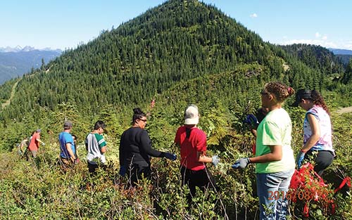
Indeed, reconnecting tribal peoples to these lands is a significant point of emphasis. That is why the work in our 10-year co-management plan was initiated this past August by the Tulalip youth who participated in Mt. Camp 2016. The energetic youth worked under the diligent supervision of Tulalip Forestry staff to remove conifers that diminish opportunities to gather huckleberries.

Since the youth kicked off the project, our Forestry Division staff worked two very long weeks in the mountains reducing the stocking of trees in the area. By reducing trees stocks, the huckleberry plants are able to prosper in areas they would have otherwise been shaded-out and killed. During the two-week window of intensive work, Forestry received welcomed help from different Natural Resource Department divisions who stepped up and spent a day or two in the field helping out.


huckleberry-2


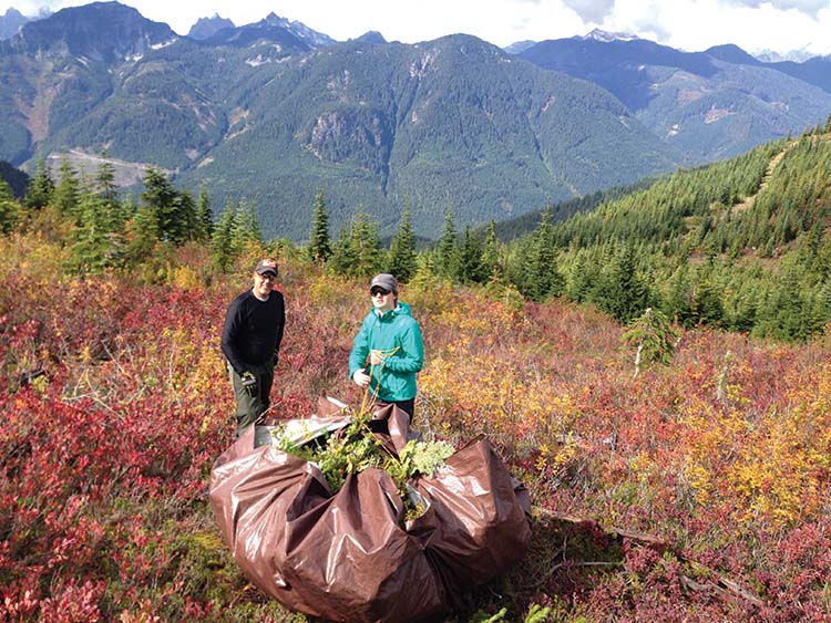
“Now that the first year’s huckleberry field enhancement efforts are completed it’s very satisfying to know that all the years of planning and a couple weeks of hard labor will enable current and future generations to enjoy harvesting huckleberries in this beautiful setting for many years to come,” state Tulalip Forestry staff members Nick Johnson and Ross Fenton in a joint statement. “We’ve been able to participate in a collaborative effort to successfully mimic conditions historically managed by Native Americans and nature. By using methods to preserve the productive capacity of this area, it will continue to produce important food and medicine for the Tribes.”

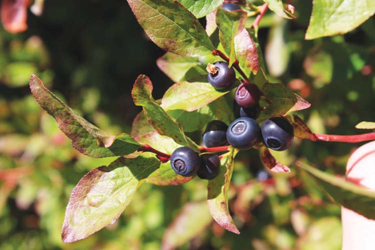
Northwest huckleberries are generally picked in the late summer/early fall seasons, and grow in the damp areas of mountains. The huckleberry, known for boosting the immune system, has always had a strong relationship to the indigenous peoples of the northwest. Coastal Native American ancestors considered the huckleberry to be of the utmost importance because of the medicine the plant contains.

“Huckleberry is a food and medicine to our people. Our ancestors visited certain areas for gathering these berries. They knew where the berries were growing, and what companion plants were growing there too and how to use them,” says Inez Bill, Rediscovery Program Coordinator. “Through the teachings of how we value, take care of and utilize our environment, we pass down our history and traditions, and what is important to the cultural lifeway’s of our people. This connection to the land enables us to know who we are as a people. It is a remembrance. Today, it is not only important that we continue the struggle to uphold our treaty rights, but we need to be involved in taking care of those resources our culture depends on so that they will be available for our future generations.”

The swədaʔx̌ali area, while co-managed by Tulalip and the U.S. Forest Service, remains open to public access as part of the Mt. Baker-Snoqualmie Forest. The Forest Service has worked with Tulalip through our MOA to ensure treaty access beyond a locked gate so that elders and other tribal members can more easily get to the berry patch during picking season. This access has been managed by our Forestry Division on behalf of the tribal membership.


huckleberry-3


There is a serious need to bring awareness while sharing the significance of swədaʔx̌ali  to the Tulalip citizenry. These places of co-stewardship are open to all of Tulalip, but there aren’t many who know how to access them, or that they even have these resources available to them. As Inez reiterates, “This work at swədaʔx̌ali  is an expression of Tulalip’s sovereignty regarding our foods, and our commitment to support the dietary needs and the life ways of our people.”

For those who would like to know more about this area, please contact Tulalip Treaty Rights Office at 360-716-4639 or Tulalip Forestry at 360-716-4370.

Forest Service Considers Thousands Of Acres For Geothermal Leasing

Geologists Dave Tucker (left) and Pete Stelling (right) at the Mount Baker hot springs in Washington's Cascade Mountains. The Forest Service says the springs will not be disturbed, but they are within the large tract of federal land that could one day be open for geothermal development.Ashley Ahearn
Geologists Dave Tucker (left) and Pete Stelling (right) at the Mount Baker hot springs in Washington’s Cascade Mountains. The Forest Service says the springs will not be disturbed, but they are within the large tract of federal land that could one day be open for geothermal development.
Ashley Ahearn


By Ashley Ahearn, KUOW

The volcanic ridges of the Cascades have long been poked and prodded by people who want to know what kind of geothermal energy they’ll find beneath the surface.

But many of the Northwest’s hot spots are on public lands. And in some cases, federal land managers have prevented access by companies seeking to convert that magmatic force into clean electricity.

That could soon change. The U.S. Forest Service is pursuing plans to make more than 80,000 acres in Washington’s Mt. Baker/Snoqualmie National Forest available for lease to energy companies. A final decision on that is expected as early as this month.

Companies wanting to develop geothermal power on federal lands would then undergo a full environmental review for each proposed project. Those studies would take into account the potential seismic risk,  vehicle traffic and transmission lines that could be associated with a geothermal power plant.

The development of geothermal power is under way in some parts of the Northwest, which the industry regards as a new frontier. Within that clean-energy frontier, Mount Baker is an outpost sentinel on its northern edge. Its steaming crater and the hot springs on the mountain’s eastern flanks are drawing attention from would-be geothermal developers.

Using steam from deep beneath the earth’s surface to spin turbines and generate electricity is not a new idea. But as more and more renewable energy comes on line, geothermal delivers in a way that intermittent sources like wind and solar do not: it provides a consistent source of what industry insiders call “baseload” power. That’s appealing to utilities like Snohomish PUD.

“A baseload renewable resource is something to treasure. We view it as a very attractive possibility,” said Adam Lewis with the Snohomish Public Utility District. The district has spent $5 million researching geothermal developments in Washington and is interested in building a traditional geothermal plant in the Mt. Baker/Snoqualmie National Forest to power roughly 20,000 homes.

The Forest Service’s move has raised concerns about negative impacts on natural ecosystems. Fifteen conservation groups have submitted a joint lettercommenting on the service’s proposed lease.

“We should be looking at everything but is this really where we need to be looking and if we are, we need to be real careful going up into wild rivers or intact forests,” said Tom Uniack, Conservation Director for Washington Wild.

The groups pushed for stronger protections on rivers and roadless sections of the forest, as well as certain forested areas that provide old growth habitat for northern spotted owls and marbled murrelets — two bird species that are protected under the Endangered Species Act.

How big is the Northwest’s geothermal potential?

California leads the world in geothermal power generation. Development has also grown in Nevada and Utah, but the Northwest lags behind.

Despite the region’s iconic volcanoes that rise up from the Cascade Range through Oregon and Washington, the geothermal potential in the region varies greatly. In Washington, hot spots appear to be limited to areas immediately surrounding volcanoes like Rainier and Baker.

Less than 5% of the total hydrothermal heat discharge from the Cascades occurs north of latitude 45N, according to research from the US Geological Survey. Less than 5% of the total hydrothermal heat discharge from the Cascades occurs north of latitude 45N, according to research from the US Geological Survey.  USGS

Research from the U.S. Geological Survey shows extensive hydrothermal heat discharge in large stretches of the Cascades in Oregon, an indication of geothermal potential, particularly in the state’s southern and eastern stretches. But those heat signatures drop off as you head north of Mount Jefferson and the Three Sisters peaks.


In Washington, the places that could provide geothermal power appear to be even scarcer. Steve Ingebritsen, a geologist with USGS, found that less than 5 percent of the total hydrothermal heat discharge from the Cascades occurs north of the Oregon/Washington border.

“Maybe that’s because the high rainfall and snowfall and snowmelt and fractures near the surface are allowing the water to percolate down and mask the geothermal indicators we’d be looking for,” said Pete Stelling, a geology professor at Western Washington University in Bellingham. “But we don’t really know. We’re still on the hunt right now.”

The Washington Department of Natural Resources has analyzed temperatures in more than 450 wells around the state and found similar results.


The Washington Department of Natural Resources has analyzed more than 450 wells to chart subterranean temperatures around the state.


But that doesn’t mean it’s game over in the pursuit of geothermal energy in the Evergreen State.

“Although the geothermal potential of Washington is lower than other West Coast states, such as Nevada, Oregon and California, there are still areas of relatively moderate to high potential,” said Dave Norman, state geologist with DNR.

The DNR sampling highlighted hot spots at Mount Baker and the Wind River area as the best places for further geothermal exploration in Washington. (You can look at their mapped well data here.)  There are currently no geothermal electricity generating plants in operation in the state.

In Oregon, geothermal energy provides heat for the city of Klamath Falls but geothermal electrification plants are still few and far between, despite a more extensive geothermal resource than that of Washington. There are two plants in operation – a small one in Klamath Falls at the Oregon Institute of Technology and another 30.1MW facility in Malheur County, which borders Idaho and Nevada.

Seattle-based company, AltaRock is piloting new hydroshearing geothermal technology at the Newberry Crater in Central Oregon, where the Forest Service has already issued a 53,000 acre lease in the Deschutes National Forest.


A scene at Mount Baker Hot Springs, where litter and personal belongings can be found scattered on the ground.
A scene at Mount Baker Hot Springs, where litter and personal belongings can be found scattered on the ground. Ashley Ahearn


Retreating to nature vs. harnessing nature

Orange peels, beer bottles and discarded bras and bathing suits litter the Mount Baker Hot Springs when Dave Tucker, co-director of the Mount Baker Volcano Research Center, and Western Washington University’s Stelling arrive. This area is a hot spot for local college students as well as geothermal energy researchers.

“104.1, 104.3,” Tucker reads temperatures (in degrees Fahrenheit) off his sensor. A broken bottle crunches under his boot. “It’s not, certainly you wouldn’t generate any power from this thing but it’s an indicator that hot water can reach the surface here.”

The springs are within the area of national forest currently under consideration for potential geothermal leasing, though the Forest Service says that any development near the springs would undergo a comprehensive review and the springs would not be disturbed.

The faint rotten egg smell and warm surface temperatures in this pool are enough to interest energy companies and utilities in exploring this area further.

A few hundred yards up the hill from where the geologists scrutinize mineral deposits and algae growth around the murky pool, a tent peeps out of the trees. Four college students groggily make breakfast on their camp stove.

“Does anyone want bacon?” asks Nathan Sundyne, a student at Western Washington University.

Samantha Miller sits in a camp chair nearby.


Samantha Miller and Paul Bikis, students at Western Washington University, enjoy the Mt. Baker hot springs. “I think it’s cool the idea of harnessing natural energy," Miller said, "but if it really compromises the integrity of the area that would be kind of sad.”
Samantha Miller and Paul Bikis, students at Western Washington University, enjoy the Mt. Baker hot springs. I think it’s cool the idea of harnessing natural energy,” Miller said, “but if it really compromises the integrity of the area that would be kind of sad.” Ashley Ahearn


“I think it’s cool, the idea of harnessing natural energy like that,” she says.  “But if it really compromises the integrity of the area that would be kind of sad.”

“Do we destroy the habitat we have, that we get to sit around and enjoy, for energy for more houses and development – growth for the sake of growth?” Paul Bikis, a fellow student asks. “Or do we want to preserve the places that we cherish?”

As Tucker and Stelling hike out of the hot springs area, Stelling pauses to pick up a discarded beer bottle.

“People say ‘no [geothermal development] –  it’s so pretty here,’ and then they leave this mess around,” Stelling said, frustration in his voice. He acknowledges that harnessing geothermal power does come with some local environmental impacts, but he says that we can no longer afford to be “hamstrung” by the “not in my backyard” approach to new clean energy projects.

“If we want to save the environment and be the environmentalists that we hope that we are, then we need to consider what we’re doing on a bigger scale.”

Forest Roads: The future

Mt. Baker-Snoqualmie National Forest
 
Mt. Baker-Snoqualmie National Forest Service, www.fs.usda.gov/mbs
Everett, Wash., June 10, 2013—Each year five million people visit the Mt. Baker-Snoqualmie National Forest. They drive forest roads to get to their destinations, to experience spectacular vistas at places such as Big Four Ice Caves, Mt. Baker, Heather Meadows, Skagit Wild and Scenic River and Pacific Crest National Scenic Trail. But what does the future hold for these beloved places?
 
Approximately 2,500 miles of roads crisscross the forest, from the Canadian border to the Mt. Rainier National Park on the western Cascades.  The Forest Service can afford to maintain about a quarter of them.
 
Guided by mandates in the 2005 Travel Management Rule, each national forest must identify a road system by 2015 within budget for safe travel, use, administration and resource protection.  To complete this report, the Mt. Baker-Snoqualmie National Forest staff wants to find out what roads are important to the public and why.
 
Eight meetings are scheduled June through October in Seattle, Sedro-Woolley, Issaquah, Bellingham, Enumclaw, Monroe and Everett. Those who do not attend a meeting will be able to give their input online­­­­­­­­.   Partners and stakeholders representing a broad range of interests, from environmental, timber industry to off-road vehicle groups, have formed a “Sustainable Roads Cadre” to engage the public in the process. 
 
A science-driven approach developed by the Forest Service’s Pacific Northwest Research Station and Portland State University will be used to understand how people use and value landscapes and resources. Social scientists from the lab will guide meeting participants in using maps to identify places of significance and assign values or activities associated with them.  
 
This process creates socio-spatial layers that will be incorporated into digital map data to contribute to the report and can be used for future recreation and stewardship planning.  The results will provide visual displays of visitor destinations, routes, and show places with special meaning or value. 
 
The forest will share the results with the public in the late fall after the report is compiled and analyzed.  No decisions will be made.  Before doing road upgrades, closures, decommissioning or road conversions to trail, the forest will execute the National Environmental Policy Analysis.
 
“The future is uncertain. But that doesn’t mean we can afford to stand back and let circumstances dictate our decisions for us. This analysis will guide us, in a holistic forest-wide approach, choosing the roads we can afford to keep open,” said Jennifer Eberlien, forest supervisor. 
 
 
MEETING SCHEDULE
RSVP to sustainableroads@gmail.com, capacity is limited and attendance is on a first-come basis.
 
June 29, 10 a.m.-12:30 noon
July 9, 10 a.m.-12:30 noon
July 23, 5:30-8 p.m.
Aug. 6, 11 a.m.-1:30 p.m.
Aug. 21, 4:30-7 p.m.
Sept. 10, 5:30-8 p.m.
Sept. 24, 1-3:30 p.m.
Oct. 9, 5:30-8 p.m.