Sunday marks one year since a deadly landslide near Oso, Washington, killed 43 people.
Wednesday, Governor Jay Inslee awarded the state Medal of Valor to four communities affected by the natural disaster. The ceremony took place during a joint session of the state legislature.
Volunteer rescuer Quinn Nations accepted the award on behalf of the town of Darrington.
“You know we appreciate it on behalf of Darrington, it’s quite the honor,” he said. “But I hope you have about 2,000 more of them because there’s a lot of people here who deserve one of ‘em. Steve Skaglund said it best when he made a statement about the slide, he said ‘look what the American people can do if you just untie their hands’”
Skaglund is a logger who used heavy equipment to help build a bypass road around the area of highway covered by the slide.
The Washington state Medal of Valor recognizes individuals who risk serious injury or death to save or attempt to save the life of another. This year the decision was to give the honor to the many individuals from the surrounding area who were involved in the rescue, recovery and relief efforts following the landslide.
Meanwhile, Washington lawmakers are considering two Oso-related measures. One clarifies that a statewide fire mobilization can be declared in the event of the major natural disaster. That request was denied after Oso because it wasn’t a fire.
A second piece of legislation would require the state Geological Survey to use the best readily-available technology to identify and map hazard zones.
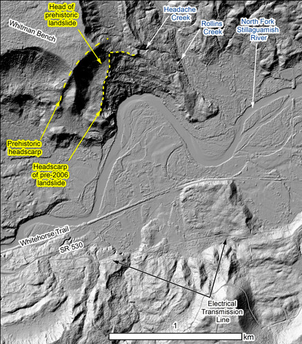
The most obvious example of this is using Lidar technology — something akin to a three-dimensional x-ray of landforms — to map these hazards. The bill would also require the Geological Survey to create and make publicly available a database of Lidar and geological hazard maps.
Washington’s Department of Natural Resources is requesting nearly $7 million to expand its Lidar mapping program.
Something that is not under consideration in the Capitol is a requirement for a special disclosure statement when homes or property in a mapped hazard zone are sold. This is a requirement in California.
OLYMPIA…The state Medal of Merit and Medal of Valor will be presented during a joint session of the Legislature Wednesday at 11 a.m. in the House Chambers in the state Capitol. Gov. Jay Inslee will award the medals.
The Medal of Merit will be presented to Gretchen Schodde and posthumously to Billy Frank Jr.
Schodde, of Union, Mason County, is receiving the award in honor of her work as founder of Harmony Hill Retreat Center in Union, which focuses on wellness and renewal for individuals and families affected by a cancer diagnosis.
Frank, a longtime Olympia area resident who died last May, is being honored for his tireless work as a Nisqually tribal leader and dedication to the plight of Northwest salmon, the environment and peace between diverse cultures. Frank’s sons, Willie and Tobin Frank, will accept the medal on his behalf.
The Medal of Valor will be given to the communities Oso, Darrington, Arlington and Sauk-Suiattle Indian Tribe for their recovery and relief efforts following the Oso landslide tragedy last March.
The Office of Secretary of State oversees the Medal of Merit and Medal of Valor program.
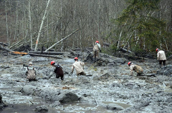
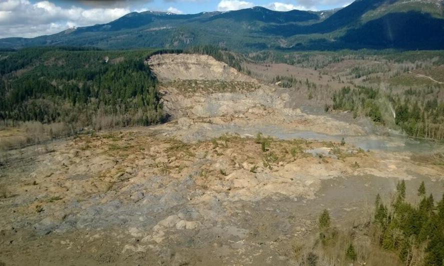
A photo taken immediately after the March 22 slide that killed 43 people and destroyed dozens of homes in Oso, Washington. A new scientific reports says a history of landslides and a huge volume of precipitation were big contributors to the slide. | credit: Washington Department of Transportation
SEATTLE — Scientists have concluded that rain, groundwater seepage and a long history of big landslides likely contributed to the massive landslide of March 22 that killed 43 people and destroyed dozens of homes near Oso, Washington.
Those findings came out Tuesday, the result of a scientific team’s rapid-fire assessment of geology and localized factors.
Joe Wartman, a University of Washington associate professor of civil and environmental engineering and a co-lead author of the study, said rainfall very likely played a key role in the slide.
“It mobilized as the water entered the landslide mass. It raised the water pressure in that mass,” Wartman said, “And as a result the landslide mass lost its strength and it became a fluidized mass of earth and material.”
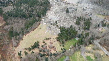
The U.S. Geological Survey estimates that 7.6 million cubic meters of earth slid down across the Stillaguamish River, spreading out for more than a kilometer.
The researchers also looked further back in history, reviewing evidence from a number of large landslides in the Stillaguamish Valley around Oso during the previous 6,000 years. The team estimated that, based on a review of carbon dating and maps of 15 similar historic landslides nearby, slides such as the March event have happened in the same area as often as every 400 to 1,500 years historically.
“The real different thing about that particular spot was how much it had failed in the very recent past,” said Dave Montgomery, a geomorphologist with the University of Washington and co-author of the report. “It had been chewed on a lot by prior failures.”
A 2003 lidar map of ground conditions where the Oso slide occurred.
The report authors said the landslide occurred in two phases. The first slope failure was a repeat of previous slides that had been documented as far back as the 1950s at that site. The most recent one to contribute to the March slide took place in 2006.
The second phase of the March 22 event tapped into a much deeper landslide history at the site.
“You have the really big ones from thousands of years ago,” Montgomery said, “But why did the piece of the slope fail that did? It was different from some other areas up and down the valley due to the history of failure in recent decades, which exacerbated the stability problem.”
The report raised a question that was brought up in the immediate aftermath of the slide: what role did logging play? But the authors said that they were “not in a position to answer the question of what degree forest practices contributed to this slide.” Any conclusions would require further modeling and were beyond the scope of this four-day reconnaissance effort, they said.
Logging can contribute to weakened root strength, allowing hillsides to slough off in heavy rain. But Montgomery said the team was pretty comfortable ruling out that idea because the slide was too big and roots would have been too thin to make a difference in preventing the massive amount of earth from loosening.
Another potential connection to logging is from the removal of trees that would otherwise have absorbed some of the precipitation, preventing it from seeping deep into the soil and loosening it. Groundwater seems to have been a key contributor to the destabilization of the slope near Oso, the report authors concluded. Montgomery said the team saw seeps of water coming into the exposed face, or scarp, of the landslide from neighboring creek basins to the east.
“We located five or six groundwater seeps where water is coming out of the wall of the slide and forming a little stream that is running across the scar,” Montgomery said. That stream could have destabilized the earth far below the surface of the slide, contributing to its size and extensive runout zone.
The authors concluded that methods to identify and predict potential landslide runout zones need to be revisited and re-evaluated. The use of LIDAR imagery could also provide a great deal of assistance in gathering historic evidence that landslides of this magnitude have run across the valley before, said Jeff Keaton, a principal engineering geologist with AMEC Americas, who contributed to the report.
“That would be a really helpful step in understanding how widespread this kind of process actually is,” he said.
But there’s more digging to be done, literally, said Joe Wartman.
“The hole we have at this point is understanding what was going on underneath the ground surface,” Wartman said. “I think the next big thing is drilling holes into that landslide and the nearby vicinity to get an understanding of what is underneath that large landslide.”
The authors called for further modeling in order to better understand to what degree logging or the Stillaguamish River, which was eating away at the toe of the slope, may have contributed to the catastrophic slide.
The USGS and others will be conducting field research in the coming months. You can read the full report here.
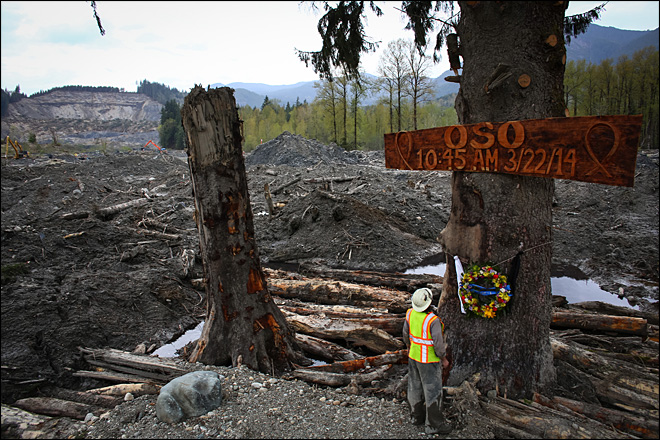
Ben Woodward looks up at a sign commemorating the moment of the Oso mudslide. The wooden memorial was attached to a towering spruce tree, one of the few in the debris field left standing after the disaster. (AP Photo/seattlepi.com, Joshua Trujillo)
EVERETT, Wash. – The Snohomish County sheriff’s office says search and rescue personnel believe they have located the last body from the deadly March 22 mudslide that killed 43 people at Oso.
Although the search for victims ended in April, workers have been screening debris and watching for the body of 44-year-old Molly Kristine “Kris” Regelbrugge.
Details were expected to be released at a news conference Tuesday afternoon in Everett.
Her husband, Navy Cmdr. John Regelbrugge III, also was killed in the slide that hit their home. His body was one of the 42 recovered earlier.
The discovery came on the same day that a team of scientists released the results of a report into the causes of the deadly mudslide.
The report says intense rainfall likely played a major role in triggering the slide, but that many other factors also contributed, such as previous landslide activity that also weakened the slope that collapsed.
The team says the slide, the deadliest in U.S. history, occurred in two major stages. A fast-moving mudflow remobilized a 2006 slide, bringing down old slide deposits across the valley. Another slide followed a few minutes later.
The report makes several broad recommendations that include doing an examination of landslide risks and communicating the information to the public.
TULALIP – With the recent events surrounding the major mudslide that occurred four miles east of the OSO community and resulted in 42 confirmed deaths, cities across the region are re-examining their emergency preparedness plans. In Tulalip, with help from a 2011 $137,000 Tribal Homeland Security grant, a plan is in the implementation phase to provide long-term food and water storage for the Tulalip Reservation.
The need for such a plan arose during the Tulalip Tribes 2010 emergency planning update that included the Tribe’s housing mitigation plan. It was noted at that time that the Tribe lacked the capability to store long-term food or water in the case of a catastrophic event.
Starting in the fall of this year, Tulalip citizens will begin to notice 8×20-foot mobile or cargo trailers placed around the reservation. These trailers will be stocked with 72-hour emergency kits with solar radios and long-term shelf food.
To ensure citizen’s dietary needs are considered, Sandy Evans the Tulalip Medical Reserve Corp Coordinator, will work with a dietician to purchase foods that meet dietary standards, such as diabetic approved foods.
“We are also looking to buy about 30, 55-gallon water barrels and water purification methods and blankets,” explained Rochelle Lubbers, Tulalip Tribes Emergency Management Coordinator. “The emergency kits are the largest cost, and we are not putting a large emphasis on buying shelter equipment, because history shows that people want to stay near their home. They find a way to either camp near their home, or find a relative to stay with. If we ever did need extra sheltering the Red Cross would help.”
Lubbers explains the storage trailers being purchased are specifically to be used in case of catastrophic disasters that would impact not only Tulalip, but also the region surrounding Tulalip, and will be used to service the entire Tulalip Reservation, including non-Tulalip members.
“I can’t say there is a distinction at this time in the plan regarding non-tribal members. The trailers will be located in areas populated with tribal housing, so they naturally favor our tribal members. With that said, once something occurs, we are not going to disregard the need of other people in the community, we will all have to come together,” said Lubbers.
“Ideally we want these storage trailers to become a part of the community. We want the community to feel trained and have supplies accessible. The idea is to get the neighborhoods involved in preparedness,” Lubbers explained. “If you can imagine a regional earthquake that affects multiple cities at the same time, we have to realize no one is coming to help for several days. We are truly on our own.”
This realization that Tulalip could become isolated from surrounding cities is what Lubbers hope neighborhoods will consider when making their own preparedness plans, along with the risk that individual neighborhoods within Tulalip could also become isolated during catastrophe.
Tulalip Emergency Management office will begin announcing trailer placement soon, along with conducting outreach for people interested in being trained in preparedness regarding the emergency storage trailers.
For more information about emergency management, or Tulalip Tribe’s emergency management plan, please contact the Tribe’s emergency management office at 360-716-5945.
Brandi N. Montreuil: 360-913-5402; bmontreuil@tulalipnews.com
Arlington, WA – Fans can name their ticket price and support Oso at the Everett AquaSox’s “Good Karma Monday,” being held on Monday, June 16th. One hundred percent of all proceeds from ticket sales at the booth will go to support the Cascade Valley Hospital Foundation’s Oso Landslide Relief Fund. Throwing out the first pitch will be Assistant Chief Toby Hyde of the Oso Fire Department. We will also welcome other members of the Oso Fire Department and their families. Game time is 7:05pm.
The Cascade Valley Hospital Foundation is grateful to the Everett AquaSox for their support of the mudslide relief efforts through “Good Karma Monday.” Funds raised through this event will help fund the continuing needs of those affected by the slide through the Foundation, a local 501(c)3 organization.
“We are very excited about Good Karma Mondays as we will be able to partner with a tremendous sponsor in Heritage Bank and at the same time raise much needed funds in our community,” said Brian Sloan, VP of Corporate Partnerships for the Everett AquaSox. We would also like to thank Whidbey Island Bank for their generous sponsorship of “Good Karma Mondays.”
For more information about the Cascade Valley Hospital Foundation, please go to www.cascadevalley.org/foundation. To learn more about the Everett AquaSox, please visit their site at www.aquasox.com.
OSO — The damaged stretch of Highway 530 closed since the deadly March mudslide will reopen to traffic this weekend, state transportation officials said Thursday.
Exactly when it will open is to be announced today by the state Department of Transportation, whose leaders had predicted it would be mid-June before enough slide debris could be removed to enable safe travel by drivers.
When it reopens, the road will be a single lane and a pilot car will lead vehicles in each direction, as is done now on the parallel Seattle City Light access road that has served as a temporary route for the past month.
The March 22 mudslide killed 42 people and entombed a mile-long stretch of the highway under more than 100,000 cubic yards of debris. One person, Kris Regelbrugge, is still missing.
IMCO Construction of Ferndale received a $4.9 million contract to clear the debris in preparation for another contractor to repair and reconstruct damaged sections. The state might award a contract for that work as early as today.
In recent days, as IMCO workers removed more and more material, state transportation officials got a better sense of the extent of damage.
Most of the original road is intact, with slightly more than 500 feet actually missing, said WSDOT spokesman Travis Phelps on Thursday. That section will be lined with gravel and rock when the single-lane road is reopened, he said.
The state isn’t expected to restrict who can use the one-lane road.
Meanwhile, residents and community leaders plan to gather along the closed road Saturday morning for a moment of silence. Then they, with Gov. Jay Inslee and Transportation Secretary Lynn Peterson, will walk the road.
This will be one of the final events before cars and trucks are allowed to drive by the Steelhead Haven neighborhood wiped out in the disaster.
File photo of landslide near Oso, Washington. credit: Washington Governor’s Office File photo of landslide near Oso, Washington. | credit: Washington Governor’s Office
A federal geologist doubts the cause of the deadly landslide near Oso, Washington will ever be fully pinned down.
During testimony in Olympia Monday, U.S. Geological Survey scientist Jonathan Godt said heavy rains in February and March certainly contributed to the slide. Geologists have also ruled out an earthquake as a trigger. But Godt says a big missing piece is groundwater flows, for which there’s no data.
“We didn’t have instruments in the ground at the time the landslide occurred and you can’t put the slide back up on the slope,” Godt said. “So from an observational standpoint, that opportunity is lost.”
Godt spoke to the Washington Forest Practices Board, a panel which is reexamining logging rules around landslide prone areas. A Washington state geologist and a private consulting geologist also presented there Monday. None would speculate if historic clear-cuts had anything to do with the March landslide.
Investigators are asking for more money from FEMA to probe why the Oso landslide traveled so far from its origin.
The death toll from the March 22 slide in Snohomish County stands at 41. Two additional people are still listed as missing.
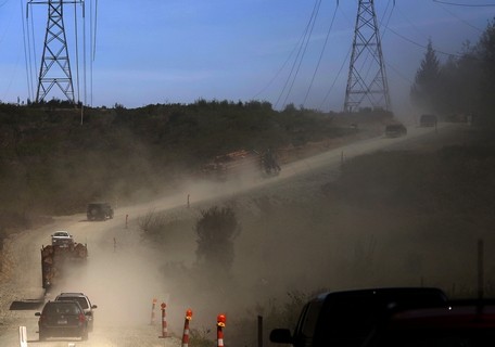
Mark Mulligan / The Herald Vehicles kick up dust as they travel eastbound on the service road bypass of Highway 530 toward Darrington Tuesday afternoon. Photo taken 20140429
OSO — The single-lane access road that bypasses the debris field of the Oso mudslide opened Tuesday morning.
It didn’t take long for grateful commuters to line up. State Department of Transportation spokesman Travis Phelps said as many as 60 vehicles at a time queued up to make the trip past the slide zone on the first day.
The access road off Highway 530 is accessible around the clock to local traffic, providing a much-needed lifeline to Darrington.
All trips are escorted through with a pilot car, leaving eastbound at the bottom of the hour and westbound at the top of the hour.
In many ways, it’s like a ferry line for passage to a remote island, with cars queueing up and neighbors getting out to chat to await the signal for the convoy to move forward.
Naomi Lieurance had gone to an appointment in Mount Vernon Tuesday morning with her shi tzu, Harley, via the Highway 20 route.
She had heard about the road opening during the day and was now waiting in line in Oso to return home to Darrington, hoping the new route will improve her access to the rest of the county.
“It’s got to be better than the Mountain Loop Highway,” she said.
She chatted in line with fellow Darrington resident Jake Sowers, who came over the access road earlier in the morning with his wife and was now heading home.
“I didn’t think it was as bad as I thought it was,” Sowers said. Approximately two dozen vehicles, including several logging trucks, made the 1:30 p.m. trip past the slide area to Darrington.
The view along the two-mile access road is not for the faint of heart, however.
The route skirts the edges of the slide zone. Trackhoes and construction vehicles below are dwarfed by a surrounding sea of rolling hillocks of mud and giant piles of broken timber. An American flag hangs from halfway up a denuded tree trunk.
The convoy passes stands of birch trees with new leaves and a pile of mangled cars. Behind it all is the exposed slope of the 650-foot cliff that slammed down into the valley on March 22.
“The horrific magnitude of it doesn’t sink in until you’ve seen it,” said Sowers, who laid eyes on the slide for the first time Tuesday morning.
A former ship’s mate, Sowers said, “I’ve seen some sad things in my life. I once surveyed a sunken ship, and this is right up there with it.”
The unpaved route is steep in places, with the convoy kicking up dust as it creeps over the hills.
According to the transportation department, only local traffic will be able to use the access road, and logging trucks will be able to use the road between 5 a.m. and 5 p.m.
No vehicles pulling trailers are permitted. The speed limit is a constant 10 miles per hour, and no stopping is permitted along the two-mile route.
The pilot cars and security at the two ends of the road are staffed by contractors hired by the state. Granite Construction Co. of Everett has been awarded a $3.4 million contract to maintain the access road and drive the pilot cars. Another firm, Seattle-based Central Protection, is providing security services.
The route is expected to remain open until at least one lane of Highway 530 is reopened. When that will happen is not immediately known, Phelps said.
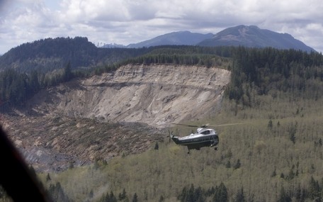
EVERETT — President Barack Obama saw the devastation of the Oso mudslide for himself today, touring the area by helicopter.
Marine One flew directly over the site, giving him a view of the massive debris field and blocked North Fork Stillaguamish River
A couple of bright-yellow excavators could be seen operating below, digging in the earth as part of the ongoing effort to recover the bodies of those who died. Amid the wreckage, an American flag flew at half staff.
Marine One touched down at Arlington Airport about 1:30 p.m.
The president then headed off by motorcade to Oso.
The visit marks one month since the disaster that took at least 41 lives and destroyed part of a state highway.
The president planned to meet with victims’ families, survivors and first responders in Oso.
Obama last visited Snohomish County in 2012 to tour the Boeing Co.’s 787 production line at Paine Field. He is the sixth sitting president to set foot in the county, and the first to come here after a public tragedy.
Air Force One, a 747-200 built in Everett, touched down at Paine Field at 12:38 p.m. Those waiting to greet the president included Gov. Jay Inslee, Snohomish County Executive John Lovick, Everett Mayor Ray Stephanson, Seattle Mayor Ed Murray, U.S. Sens. Patty Murray and Maria Cantwell and U.S. Reps. Rick Larsen and Suzan DelBene.
The governor, Murray and Cantwell accompanied Obama in his helicopter.
A sparse crowd gathered nearby to watch, but they were outnumbered by media and officials.
The president was expected to meet face-to-face with people who have been wrestling with the loss and challenges since the hillside fell on March 22.
Police and fire vehicles were lining up along the Arlington Airport entrance by 11:30. Snohomish County Sheriff’s Lt. Rodney Rochon leaned out his window to greet the arriving state motorcycle troopers. Black SUVs with Maryland plates followed them in onto the airfield.
Families and couples with babies and lawn chairs arrived at the airport, hoping for a glimpse of the president. They looked up as helicopters hummed overhead. Some waved at the sky. A toddler in a yellow jacket played in the grass, her mother’s watchful eye following her.
By 1:15 p.m., engines were running in the motorcade. Secret Service agents gave the vehicles a quick rub with dust rags, making them shine. They straightened the small flags on SUVs and applied a presidential seal decal.
Activity in the motorcade became still as multiple CV-22 Ospreys and other aircraft landed on the tarmac at Arlington Airport.
Firefighters from Arlington and Marysville snapped pictures as Obama got into the motorcade and headed away toward Oso.
Larsen, who grew up in Arlington, said in a prepared statement. “The President’s visit today underscores the country’s commitment to helping Oso and Darrington heal and recover. I am pleased President Obama will meet with survivors and community leaders to hear their stories. He will learn about the many challenges of rebuilding but also the incredible resilience of the people in these communities.”
Obama “will see this strength in action today,” Larsen said.
Aboard Air Force One en route to Everett, press secretary Jay Carney told reporters that the Obama administration “remains focused on supporting the state and local efforts, and first responders.”
The president earlier declared a major disaster in Oso, freeing up resources.
“I think the purpose of the visit, which will include remarks delivered at the Oso firehouse, is to view firsthand the aftermath of the terrible mudslide there, and to meet directly with those who lost loved ones and have suffered so much in this terrible tragedy,” Carney said.
Officials have now identified all 41 of the people confirmed to have died in the slide. Two other people presumed killed remain missing.
Highway 530 remains blocked. A flood warning is in place for the area east of the slide along the North Fork Stillaguamish River until Thursday afternoon.
The Secret Service began arriving in Arlington, Darrington and Oso weeks ago after Obama’s visit was announced. Military aircraft could be seen flying in Marysville and Arlington over the weekend as the president’s visit approached.
Obama last was here on Feb. 17, 2012, when he toured The Boeing Co. plant in Everett and spoke to factory workers. That year was the first time in nearly two decades that a serving president visited the county.
After visiting Snohomish County, Obama is scheduled to go to Asia, with stops in Japan, South Korea, the Philippines and Malaysia, according to the Associated Press.
On Monday, the Federal Emergency Management Agency announced that assistance had been approved for people in the Arlington, Darrington and Oso areas whose commutes to work, school and medical appointments are detoured around the slide, through Skagit County. That will happen through individual FEMA assistance applications.
Businesses that need help should contact the Small Business Administration at www.sba.gov/disaster or 800-659-2955.