With the Tulalip Tribes doing the last bits of finishing work, the city of Marysville is now looking at its next big project: building 1.8 miles of new trail around the new estuary.
The city is planning a 12-foot wide paved trail that would lead from Ebey Waterfront Park down to the estuary. Another segment will run on the east side of the breached levee up to Harborview Park in the Sunnyside neighborhood.
If all goes according to plan, the two segments of trail would be complete by the end of 2016.
It’s a big deal for the city, which has relatively little in the way of publicly available waterfront.
“We’ve only had about 900 feet of access to our shoreline and this will change that significantly,” said Jim Ballew, Marysville’s director of Parks and Recreation.
The project is estimated to cost between $1 million and $1.2 million, $500,000 of which was in the most recent budget from the Legislature.
That also meant that the city’s trail project was delayed due to the extended budget debates in Olympia this year. The original plan was to have the western segment of the trail done by the end of the year.
“We had to wait for the Legislature to approve the funding, and that was so delayed this year that we don’t even have a contract yet,” Ballew said.
“We’ve got it within our capital budget; it’s ready to go,” Ballew said.
The new plan calls for finishing the design work by the end of the year and expanding the project to include not just the trail, but other waterfront improvements and interpretive signs along the route.
Further out, the plans will include the eventual construction of a mile-long loop around the estuary connecting the trail’s west and east legs.
Funding so far only exists for the initial segments, meaning there will be a gap in the trail until some time in the future.
The Qwuloolt Estuary restoration project is intended to create better habitat in the Snohomish River watershed for migratory salmon, especially juveniles that need a place to mature for up to a year or two while they gradually get used to a marine environment.
The Tulalip Tribes have spent $20 million over 20 years on the estuary, with the final levee breach taking place Aug. 28.
All that’s left now is to seal off the former tide gates and dig a final stormwater pond, said Josh Meidav, a restoration ecologist with the Tulalip Tribes.
So far, Meidav said, the results of the levee breach have met their expectations.
“The channel itself at low tide or incoming tide is actually capturing a good amount of the Ebey Slough inflow,” he said.
Some marine fish have been seen in the upper reaches of the estuary and the reed canary grass is starting to die off, Meidav said.
The city plans to reach out to the scientific community, the tribes and even the birdwatching community to provide input into the interpretive elements of the trail.
“We’ll be spending a lot of time with those specialists,” Ballew said.
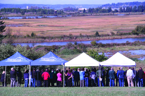
Partners from the Tulalip Tribes and a dozen other agencies and groups, including Marysville, the U.S. Army Corps of Engineers, and NOAA, take in the view of the Qwuloolt Estuary on September 2, 2015. The levee was breached August 28, allowing the return of its native marshland.
By Micheal Rios, Tulalip News
The Qwuloolt Estuary Restoration Project took 20 years to complete. The finish line was crossed on Friday, August 28, when massive excavators and bulldozers breached a levee and reopened 354-acres of historic wetlands to threatened Puget Sound chinook salmon. The levee breach culminated what has been recognized as the state’s second-largest ever estuary restoration project.
“This is a great, great day. It’s been a long time coming,” says Kurt Nelson, Tulalip Tribes’ Environmental Department Manager, at the September 2 levee breach celebration. “I’ve been on this project for 11 years and there have been many challenges and hurdles, but we’ve gotten through them all. What we have now is a 354-acre estuary wetland complex that saw its first tidal flows in 100 years last Friday [August 28].
“If you watch the live-stream webcam in fast motion, you’ll notice it’s almost like this site is breathing. The estuary is flooding and draining, flooding and draining with tidal waters, like a lung does with oxygen. It’s a nice comparison to bringing some life back to an isolated floodplain that hadn’t seen that kind of life in a longtime.”
The Qwuloolt Estuary Restoration Project (QERR) is a partnership of tribal, city, state and federal agencies aimed at restoring a critical tidal wetland in the Snohomish River estuary. The Qwuloolt Estuary is located within the Snohomish River floodplain approximately three miles upstream from its outlet to Puget Sound and within the Marysville City limits. The name, Qwuloolt, is a Lushootseed word meaning “salt marsh”.
Historically, the area was a tidal marsh and forest scrub-shrub habitat, interlaced by tidal channels, mudflats and streams. However, because of its rich delta soil, early settlers diked, drained and began using the land for cattle and dairy farming. The levees they established along Ebey Slough, as well as the drainage channels and tide gates, effectively killed the estuary by preventing the salt water from Puget Sound from mixing with the fresh water from Jones and Allen Creeks.
For the past 100 years the estuary was cut off from its connection with the tidal waters and denied the ability to act as a restorative habitat for wild-run chinook salmon and other native fish, such as coho and bull trout. Through the cooperation of its many partners, this project has returned the historic and natural influences of the rivers and tides to the Qwuloolt.
The purpose of the project is to restore the Qwuloolt Estuary to historic natural conditions, while also mitigating some of the damage caused by the now defunct Tulalip Landfill on Ebey Island’s northwest edge. The former 145-acre landfill was operated on Tulalip Reservation land by Seattle Disposal Co. from 1964 to 1979 and become a Superfund site (polluted locations requiring a long-term response to clean up hazardous material contaminations) in 1995, before being cleaned up and capped in 2000.
Qwuloolt will provide critical habitat for threatened Puget Sound chinook and other salmon, as well as for waterfowl and migratory birds. Native habitat and functioning tidal marsh ecosystem were lost when the estuary was diked and cut off from tidal influence. This project will restore tidal flows to the historic estuary and promote: Chinook, bull trout, steelhead, coho and cutthroat rearing habitat, salmon access to greater Allen Creek, migratory and resident bird habitat, water quality improvements, Native vegetation growth and restoration, and natural channel formation.
Trying to recover these critical estuary habits are crucial to migrating juvenile salmon for the salmon recovery effort in the Snohomish region. The Qwuloolt Estuary can now, once again, provide food and refuge for those fish. The intent of the project is to increase the production and quantity of those salmon that are extremely important to the Tribe and our cultural-economic purposes, as well as to the public and State of Washington.
“[Qwuloolt] is not only a nursery area for hundreds of thousands of juvenile salmon that migrate from the upper basins of the Snohomish that will come through this estuary and feed on various prey species and grow very rapidly, but also contributes to the survival of fish all over the Snohomish basin,” explains Nelson. “It will improve the water quality of Jones and Allen Creek, while being an extremely important bird habitat for migratory waterfowl, as well as restoring native wetland vegetation.”
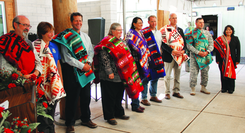
The Qwuloolt Estuary Restoration Project is overseen by a planning team with representatives from the Tulalip Tribes, NOAA, USFWS, WDOE, U.S. Army Corps of Engineers, NRCS, and the city of Marysville. Representatives from each entity were blanketed at a September 2 event celebrating the levee breach.
The US Army Corps of Engineers were responsible for the levee construction and the levee breach, while the Tribes were responsible for the channels, the berms, the planting, and some of the utility work that needed to be done. From beginning to end QERR was all about partnership and working together in getting this project done. The US Army Corps of Engineers, the Tulalip Tribes, the city of Marysville, Department of Ecology, National Oceanic and Atmospheric Administration, along with the Puget Sound Partnership and Fish and Wildlife services, all played instrumental roles in completing this project and it could not have been done without the collaboration each and every partner.
“As evidenced here today, it really has been a tremendous collaboration between the tribes and federal, state and local governments to bring this project through and really make a significant change for our environment,” says Col. John Buck of the U.S. Army Corps of Engineers. “Over the past century we’ve seen this continuing degradation of our environment in the northwest and it’s through collaboration and partnership we can really affect change.”
*The Qwuloolt Estuary project cost $20 million. That money was obtained over a 17 year period that involved federal, state and tribal money. It also includes settlement and foundation money. Property purchase was $6 million, $2 million in planning, design, permitting and studies, $10 million on the levee, and another $2 million on constructing channels, berms and all the interior work.
Qwuloolt is:
Physical stream restoration is a complex part of the project, which actually reroutes 1.5 miles of Jones and Allen creek channels. Scientists used historical and field analyses and aerial photographs to move the creek beds near their historic locations.
Native plants and vegetation that once inhabited the area such as; various grasses, sedges, bulrush, cattails, willow, rose, Sitka spruce, pine, fir, crab apple and alder are replacing non-native invasive species.
Building in stormwater protection consists of creating a 6 ½ acre water runoff storage basin that will be used to manage stormwater runoff from the nearby suburban developments to prevent erosion and filter out pollutants so they don’t flow out of the estuary.
Construction of a setback levee has nearly finished and spans 4,000 feet on the western edge on Qwuloolt. The levee was constructed to protect the adjacent private and commercial property from water overflow once the levee is breached.
Breaching of the existing levee that is located in the south edge of the estuary will begin after the setback reaches construction. The breaching of the levee will allow the saline and fresh water to mix within the 400-acre marsh.
Other estuary restoration projects within the Snohomish River Watershed include; Ebey Slough at 14 acres, 400 acres of Union Slough/Smith Island and 60 acres of Spencer Island. The Qwuloolt Estuary Restoration Project has been a large collaboration between The Tulalip Tribes, local, county, state and federal agencies, private individuals and organizations.
Contact Micheal Rios at mrios@tulaliptribes-nsn.gov
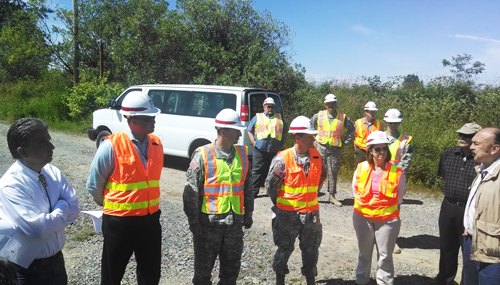
Members of the Army Corp of Engineers, Seattle division, meet with Tulalip Tribal members to tour the Qwuloolt Estuary. Photo/Andrew Gobin
By Andrew Gobin, Tulalip News
The Army Corps of Engineers toured the Qwuloolt Estuary, located in Marysville, on Wednesday, June 25, as part of a transitional period. Colonel Bruce Estok is stepping down from his position with the corps, and is introducing his successor, Colonel John Buck, to some of the communities and projects the corps is involved with. The Qwuloolt Estuary project is an example of successful collaboration between the corps and local communities with specific interests.
Col. Buck said, “The corps’ primary focus is Puget Sound. This is a great example of the corps and the tribe coming together to tackle a hard problem, which is to restore the Puget Sound ecosystem. This project is 20 years in the making, and it’s exciting to see the work happening.”
The Qwuloolt Estuary was chosen as a project site tour for a few reasons, mainly the unique relationship the corps has with Tulalip, and the importance of the project in reaching the goal of restoring the waters of Puget Sound.
“The estuary has been deemed a crucial habitat for salmon for a long time. It is crucial to any watershed. It is the place where life happens, where the land meets the sea,” said Kurt Nelson, Environmental Division Manager for the Tulalip Natural Resources Department.
“This project, the way it was organized and designed, it didn’t quite fit the corps’ normal procedures. This is a unique project,” Nelson added. “What we need for the future is a way to make procedures more flexible for unique situations, like this one.”
Col. Estok explained that the corps projects are not really part of the president’s budget, mostly due to a lack of feasibility plan. Because of that, funding is often uncertain, so the projects remain uncertain right up until the first day work actually begins.
“Tulalip Tribes is our unofficial sponsor,” said Col. Estok.
He and Nelson explained that the funding for Qwuloolt largely comes from 21 grants the tribe secured to cover project costs. Grant funding often has time constraints, which means the funds might not be available by the time the Army Corps of Engineers process is complete. That is one major obstacle that had to be overcome for Qwuloolt.
Tulalip Tribes Vice Chairman Les Parks, who represented the council at the site tour, said, “We appreciate that you guys came out, especially Colonel Buck, taking the helm now. The health of Puget Sound is faltering, and projects like this will help to restore it.”
Col. Estok noted that this is not the first collaborative effort between the corps and the Tulalip Tribes.
“We have the first in-lieu fee mitigation plan with a tribe. That’s a good relationship, one that we want to keep building on,” he said.
For more information about the Qwuloolt Estuary, visit www.qwuloolt.org.
Quilceda marsh, currently owned by The Tulalip Tribes, looking southwest down Steamboat Slough of the Snohomish River toward Port Gardner, Wa. Photo by K. O’Connell 2013
By Monica Brown Tulalip News Writer
TULALIP, WA-Wetlands are widely agreed to be some of the most beautiful places on Earth, with an array of wild and plant life that spark joy in the hearts of many.
“For many of us, water simply flows from a faucet, and we think little about it beyond this point of contact. We have lost a sense of respect for the wild river, for the complex workings of a wetland, for the intricate web of life that water supports.” -Sandra Postel, founder and director of Global Water and Policy Project, author of “Last Oasis: Facing Water Scarcity”, 2003.
Wetlands can be considered the hub of life, where land and water meet you will find an overabundance of life flourishing. Currently most wetlands are threatened with rising sea levels, pollutants and development.
A recent study conducted by Restore America’s Estuary, on the Snohomish estuary, begins to pinpoint the essential need for healthy estuaries and their link to global health. For the study, soil samples (from Smith Island, Spencer Island and Qwuloolt to name a few) were taken in order to establish a count of CO2 emissions that are captured and stored within estuaries that vary in health condition.
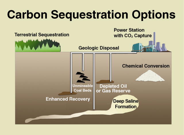
Image Source: Big Sky Carbon
There are numerous ways to remove carbon emissions, most are natural and work through plant life such as forests while others are less natural and work through power plants that capture CO2 and bury it back into the earth or ocean. Coastal wetlands have been labeled as Blue Carbon sequesters and have been found to greatly reduce atmospheric CO2 emissions. Throughout the USA, tidal marshes, tidal forests, saltmarsh grasses, seagrasses, and the mangroves along the Gulf Coast are more effective at sequestering carbon (up to a 100 times faster) and are able to store it for longer periods of time as compared to forests.
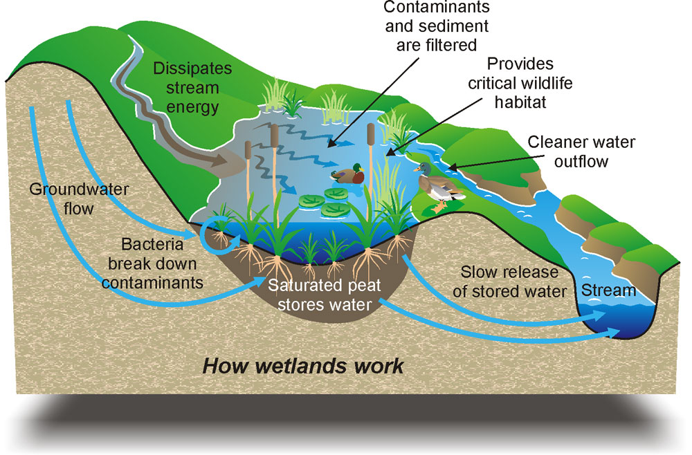
Image Source: bragio.com
“This report is a call to action. We need to invest more substantially in coastal restoration nationwide and in science to increase our understanding of the climate benefits which accrue from coastal restoration and protection efforts,” said Emmett-Mattox, Senior Director for Restore America’s Estuaries and co-author on the study. “Sea-level rise will only make restoration more difficult and costly in the future. The time for progress is now.”
Through this study a blue carbon working group can be established which will focus, for years to come, on restoring and monitoring Pacific Northwest region coastal wetlands in order to continue collectingand analyzing data which will help to influence better-quality land management, update policies that could one day apply to wetlands nationally.
Due to human impact, coastal wetlands are disappearing at a rapid rate, “at current conversion rates, 30–40% of tidal marshes and seagrasses and nearly 100% of mangroves could be lost in the next 100 years.” (Estimating Global “Blue Carbon” Emissions from Conversion and Degradation of Vegetated Coastal Ecosystems.Pendleton et al., 2012). Although, both are time consuming, maintenance of estuaries is more cost effective than restoring and with rising sea levels (estuary health and life depend on average sea levels), estuaries are losing ground and time has become an issue as well. This national loss of wetlands has branded the Snohomish Estuary as an excellent case study for restoration and estimates of carbon storage.
“It is very fitting that we are implementing some of the world’s leading Blue Carbon research here in Puget Sound,” said Steve Dubiel, Executive Director of EarthCorps. “We have always known that wetlands are a kind of breadbasket, thanks to the salmon and shellfish they support. Now we are learning that they are also a carbon sponge.”
“Coastal Blue Carbon Opportunity Assessment for Snohomish Estuary: The Climate Benefits of Estuary Restoration” finds that currently planned and in-construction restoration projects in the Snohomish estuary will result in at least 2.55 million tons of CO2 sequestered from the atmosphere over the next 100-years. This is equivalent to the 1-year emissions for 500,000 average passenger cars. If plans expanded to fully restore the Snohomish estuary, the sequestration potential jumps to 8.8 million tons of CO2 or, in other terms, equal to the 1-year emissions of about 1.7 million passenger cars. In addition to the climate benefits outlined by the study, healthy and restored estuaries act as spawning grounds and nurseries for commercially and recreationally important fish and shellfish species, provide storm buffers for coastal communities, filter pollutants, and provide habitat for numerous species of fish and wildlife, as well as recreational opportunities for hundreds of millions of Americans annually.