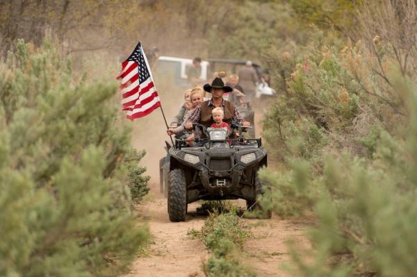
AP Photo/The Salt Lake Tribune, Trent Nelson Ryan Bundy, son of the Nevada rancher Cliven Bundy, rides an ATV into Recapture Canyon north of Blanding, Utah on Saturday, May 10, 2014, in a protest against what demonstrators call the federal government’s overreaching control of public lands. The area has been closed to motorized use since 2007 when an illegal trail was found that cuts through Ancestral Puebloan ruins. The canyon is open to hikers and horseback riders.
ATVs have not been allowed through Recapture Canyon since 2007, but that didn’t stop a group of protesters on Saturday, May 10 from riding the trail—which is full of Native American sacred sites—anyway.
The Bureau of Land Management closed Recapture Canyon in Blanding, Utah to ATVs in 2007 after enthusiasts were caught trying to construct another trail illegally, and in so doing damaged archaeological sites, reports The Salt Lake Tribune.
Saturday’s ride was a demonstration by residents and San Juan County Commissioner Phil Lyman that they want control of the lands in public hands, a fight that has been going on for eight years. Only eight percent of San Juan County is not managed by the BLM, reports the Los Angeles Times.
Lyman and others who want the canyon reopened to ATVs argue that their families have been using the land for recreation for years.
“My grandfather called that canyon the most beautiful thing he’d ever seen in his life. It’s important to our family. To see it as the focal point of a conflict is painful,” Lyman said before riding into the canyon on an ATV, to the Los Angeles Times.
People listen to San Juan County Commissioner Phil Lyman at Centennial Park in Blanding, Utah on Saturday, May 10, 2014. Lyman organized an ATV protest ride into nearby Recapture Canyon to show that the federal agency isn’t the “supreme authority” and local residents have a right to have their opinions heard. The area has been closed to motorized use since 2007 when an illegal trail was found that cuts through Ancestral Puebloan archaeological sites. The canyon is open to hikers and horseback riders. (AP Photo/The Salt Lake Tribune, Trent Nelson)
But there are others who have been in the area for far longer than Lyman and his supporters.
“Since well before the state of Nevada, the federal government, and farmers and ranchers occupied the area, tribal nations—including the Las Vegas Band of Paiute, Moapa Band of Paiute, and other tribes in the area—have respected and honored the Utah Canyon as a sacred place,” the National Congress of American Indians said in a statement opposing the ride. “Native peoples believe the canyon contains many markers from their ancestors. An action like this is no more appropriate than a similar activity at a church or other place of worship.”
This April 9, 2011 photo shows an Anasazi ruin in the cliff close to “Lem’s Trail” in Recapture Canyon, near Blanding, Utah. A San Juan County commissioner tired of waiting for the Bureau of Land Management led an ATV ride into the canyon May 10, 2014. (AP Photo/The Salt Lake Tribune, Scott Sommerdorf)
A number of other groups have also spoken out against the ride.
“We believe the [Bureau of Land Management] should be providing more law enforcement to protect and preserve the cultural and natural resources for which it is the nation’s caretaker, and not providing more motorized access to areas containing cultural and natural resources that it has demonstrated that it is unable to protect,” Leigh J. Kuwanwisiwma, preservation director for the Hopi, wrote in a May 1 letter to the BLM.
“It is sad that irreplaceable treasures of importance to all Americans would be sacrificed on the altar of anti-government fervor,” Jerry Spangler, executive director of the Colorado Plateau Archaeological Alliance, said in a statement. “It is worse that protesters would be so blinded to their own insensitivity as to what others consider to be sacred treasures of their past.”
Willie Grayeyes, chair of a nonprofit that lobbies to protect Navajo land, was offended not only by the lack of sensitivity of the riders for Native culture, but also because a veterans retreat had to be relocated because of the protest.
“This opportunity for healing, to help these men and women has been postponed due to the threats of illegal activities by San Juan County Commissioner Phil Lyman on behalf of those who desire to drive their ATV toys over the sacred ruins of others,” wrote Grayeyes in a letter to The Salt Lake Tribune.
Many are comparing this recent protest to the exploits of private rancher Cliven Bundy in Nevada, whose cattle graze for free on U.S. government land.
YAKIMA, Wash. — The Yakama Nation Tribal Court ruled it has jurisdiction in an unprecedented lawsuit that maintains that the state has responsibility to manage an elk herd to prevent damage to a sacred burial site.
Chief Judge Ted Strong found in favor of the tribal member who brought the civil suit against the state Department of Fish and Wildlife when he ruled Friday that the Tribal Court has the authority to hear the case. He ordered the parties to discuss settlement options before continuing with hearings.
Attorneys for the state had asked the court to throw out the lawsuit, saying it lacked authority over Wildlife Department officials named in the suit because they are not tribal members and because the burial site is not on the reservation.
In the case of the burial sites, the judge found that the court’s jurisdiction should not be limited to the reservation.
The case was brought under a 1989 state law allowing tribal members to seek damages in civil court against those who have knowingly damaged Indian burial sites. The law allows cases to be brought in Superior or Tribal Court, but this is the first time a case has been heard in Tribal Court.
It’s a test case for the authority of the Tribal Court, said Jack Fiander, the attorney representing Shay-Ya-Boon-Il-Pilpsh, who brought the case. Fiander said he hopes this case can demonstrate the fair, professional process of the Tribal Court.
Typically, tribal courts only have jurisdiction over cases involving tribal members and tribal lands.
“The Yakama Tribal Member who seeks preservation of the ancient burial grounds has no less right to be heard by this court simply because the remains of his fellow Yakama lies buried in the grave some miles distant from the Yakama Reservation Boundary,” Judge Strong wrote in the order granting the jurisdiction.
The tribal court is “uniquely competent” to hear concerns about the desecration of burial sites, he wrote.
Plaintiff Shay-Ya-Boon-Il-Pilpsh, who is also known as Ricky Watlamet, is charged in Kittitas County Superior Court with felony unlawful hunting after allegedly shooting several of the elk on the Kittitas County property where the burial site is located.
He was invited by the nontribal landowner who was frustrated with the Wildlife Department’s response to her complaints about damage by the elk, which were also eating grasses intended for cattle.
But under state law, tribal members’ treaty hunting rights that allow them to hunt outside of the state-set seasons don’t apply on private land.
Fiander is also representing his client in the criminal case, but he said that he’s encouraged by the Tribal Court’s decision to hear this civil case.
“I think everybody’s pleased about the decision, but we see it as chapter three of about seven,” Fiander said.
“I’m cautiously optimistic that in less than a month as the snow melts that the elk will start leaving the property and hopefully, a settlement can be reached for next year.”
In other areas with elk problems, Fiander said management strategies have included temporary fencing or issuing more hunting permits to keep the herd smaller.
A spokeswoman for the state Attorney General’s Office, which represents the Wildlife Department, said in an email that it is “reviewing the decision with our clients and considering our course of action.”
The next hearing is set for June 19, after the parties meet to discuss settlement options.
Once the Tribal Court has reached a conclusion in the case, the decision can be subject to a federal court review to ensure the process was fair, Fiander said.
But, he said he would not be surprised if the state’s attorneys planned to appeal.
“My sense is that ultimately it will end up in federal court,” Fiander said.
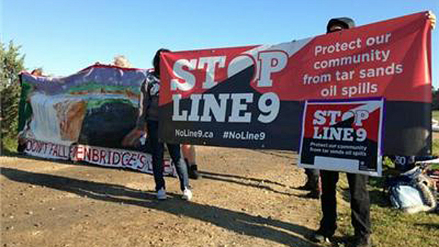
Without surprise, the National Energy Board has approved the reversal of the Line 9 pipeline. This pipeline crosses every single tributary that flows into Lake Ontario, and cuts up the north shore of the St. Lawrence river….
It was anticipated that this information be released on March. 19th. Instead the rubber-stamping came early.
Indigenous peoples whose territories are being attacked by this project have been silenced throughout this process. It is our communities, and other communities of colour, who primarily live fenceline with the tar sands, its mining, infrastructure and refineries. It is our Sacred sites that are being desecrated by the shady movements of corporate imperialists and colonial-capitalists.
Line 9 shows us exactly what environmental racism looks like, from Aamjiwnaang to Jane & Finch – telling us that bodies of colour and Indigenous bodies are expendable for the larger project of profit. Line 9 is but expanded infrastructure to move the Athabasca tar sands eastward – it is an embodiment of the slow industrial genocide that is being committed by TransCanada, Enbridge, Suncor, and the Government of Canada, to name a few.
This deep rooted social disconnection from the land is fostered by the occupation of our Nations’ territories. The attack on Indigenous bodies and bodies of colour are but a glimpse into the functions of this White supremacist, settler-colonial death culture that seeks to consume, corrupt and conquer.
On March 19th, let us keep close the truth of the violence that is this pipeline: an apparatus of tar sands destruction that seeks to poison that which sustains us and those faces not yet born. On this day we will be connected with each other in struggle as we fill our hearts with love for the wild and carry inside us a hunger for justice. March 19th Take Action Against Line 9!
We are requesting solidarity actions by friends in struggle who share Enbridge as a common enemy – from the West to the East, Enbridge’s toxic tendrils are an affront on Indigenous Sovereignty and the health of all of Creation.
—
Only you, your community and your affinity groups know what action is best to take in your area. Get in touch with us if you want to confirm an action. #Line9IndustrialGenocide
Be safe, be strong!
Keep your ear to the ground, because there are more battles ahead. Stop the beast! #NoLine9 #NoEnergyEast
Note: For more background on Enbridge’s Line 9 tar sands pipeline and the recent approval it received by Canadian regulators, click here.
On Thursday, the House will vote on a bill that would direct the Secretary of Agriculture to convey more than 2,400 acres of U.S. Forest Service land in southeast Arizona to the Resolution Cooper Mining Co. Enactment of the bill would allow Resolution Cooper, dually owed by Rio Tinto Mining and BHP Billiton, to operate a large-scale cooper mine on Oak Flat disrupting sacred tribal grounds.
If passed, this bill referred to as the Southeast Arizona Land Exchange Act, could potentially destroy sacred tribal places of worship by allowing the foreign mining giants to extract one cubic mile of ore from beneath the surface of the earth. The mining companies would extract the ore through an ecologically destructive process called block cave mining.
In 2011, ICTMN reported that Resolution Copper would use controversial block-cave method, in which explosives are set off below the ore body, creating a space underneath and allowing the ore to collapse from its own weight, after which it’s extracted. Opponents fear the method could damage Native American sacred lands, among them the historical Apache Leap, where tribal warriors leaped to their deaths rather than surrender to Arizona soldiers, according to historical accounts like this one.
In a press release, Rep. Gwen Moore (D-WI) urged colleagues to vote “no” on the bill and said that Oak Flat has been a place where Native Americans have prayed, gathered medical herbs and plants, healed in holy perennial springs, and performed religious ceremonies for decades.
“The protection of places of worship is a fight for which we should all be united,” Moore wrote in a press release to her colleagues. “We must stand together to protect places of worship, including tribal sacred sites because these sites are part of the rich heritage and culture of our country and the essence of our moral identies.” She said the bills passage would jeopardize the cultural history of other sacred sites by setting a precedent with regard to federal protection of tribal sites.
The bill was introduced by Rep. Paul Gosar (R-AZ) in February. Last month, Gosar invited the public to a town hall meeting to gage support of his efforts to bring thousands of jobs to Arizona’s Copper Corridor. He said this goal could be achieved if 678 is passed. “Getting this critical jobs bill across the finish line requires Arizonans to rise up and let their voices be heard. Nearly 4,000 jobs and billions of dollars in economic activity are at stake.”
The withdrawal of Resolution Cooper’s controversial block cave mining process is supported by the San Carlos Apache Tribes, local tribes, and some environmentalists.
Arizona Rep. Raúl M. Grijalva (D-AZ)
The project has also been opposed by Arizona Rep. Raúl M. Grijalva (D-AZ) whowrote about his oppositionto the bill saying that he was not opposed to mining, in principle, but said that they should not come at the expense of Native American rights.
ICTMN also reported that the bill would give around 2,400 acres of public land in southeastern Arizona to Resolution Cooper Co. in exchange for around 5,000 acres in several parcels around the state. As it stands, the bill has largely remained the same.
The federal government has acknowledged its obligation to protect sacred tribal grounds, but if the land swap bill passes, Moore said, Oak Bluff would be transferred to Resolution Copper for private ownership, and out of the domain of regulation by federal law.
“People who think money is first over water and land, such as some people in Washington, are destroying the earth and that’s where our argument is,” San Carlos Apache Tribe Chairman Wendsler Nosie, told ICTMN in 2010. “That’s wrong. You cannot do that, and that’s why I’m standing up for this.”
In 2002, a group of retired men began hiking together once a week in the Southern Appalachian Mountains and started finding old, scenic trails they claimed nobody knew about. They decided to revive these trails and make them available to the public, first forming a nonprofit group called Mountain Stewards, headed by president Don Wells.
Operating initially under an agreement with the Georgia Department of Natural Resources, the Mountain Stewards began work on their first trails in 2005. With the help of grants and private donations, the group has refurbished and interconnected more than 70 miles of hiking and water trails in Georgia, and constructed a number of bridges and canoe launch sites, providing safe outdoor recreation to the public and preserving the region’s cultural and historic beauty.
“It’s refreshing; you get out in nature. It’s like our own personal health-care program,” the 73-year-old Wells says by way of explaining what motivated this “trail crew of nine old men” to work two days a week, 46 weeks a year for about five hours a day.
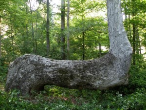
During some of their hikes, the Mountain Stewards discovered something unexpected. “We started finding Indian trails that we could document from historical maps… and we were locating oddly shaped trees on these trails that had been bent by Indians,” Wells said, adding that Native Americans used these trees like ancient global positioning systems, to help them find their way to and from a particular destination.
Realizing they had stumbled upon living Native relics, the Mountain Stewards, in collaboration with Wild South, and people from five other states, started the Indian Trail Tree Project and Indian Trails Mapping Program that aimed to map Indian trails and document these amazing trail trees not only in Georgia, but all across the country, in the highly confidential National Trail Trees database that now includes 2,034 trees in 40 states.
Now known as the Indian Cultural Heritage Program, these trail-saving efforts have evolved into a book written by Wells and his wife, Diane. Mystery of the Trees, published in December 2011, caught the attention of Sam Proctor, an elder and culture consultant with the Muskogee (Creek) Nation in Okmulgee, Oklahoma, who had a dream about a particular bent tree more than a decade ago. “When I was visiting down in south Georgia, I dreamed that my ancestors showed me a trail they used back and forth from the village to the watering hole. They also showed me this oddly shaped tree and I never even thought anything about it until I saw Don Wells’s book,” Proctor said.
Wells knew the exact spot Proctor had seen in his dream, and on a visit hosted by the author and his wife, they found the bent tree and watering hole once used by the Muskogee (Creek) Indians. “It was a very spiritual experience,” Proctor recalled.
Since then, Wells has confirmed seven other Muskogee (Creek) trail sites in Georgia and Alabama, and is making plans with Proctor for future visits. Wells has also helped elders from a number of other tribes find their ancestral roots—literally.
ICTMN talked with Wells about the Indian trail trees. A documentary about them is also in the works.
What are Indian trail trees?
Back in the 1600s and 1700s, when Indians were traveling from the Atlantic to the Pacific, and from Canada to Mexico, there were trails all over the United States. They didn’t have GPS or a map, so to find their way from A to B and back home again, they had marker trees, or trail trees, or a signal tree or a yoke tree—they had all kinds of different names for them. These trees would be bent as saplings, when they were about ¾-inch in size, and tied down. They would be left that way for a year and lock into that position. They used them to mark trails, crossing points on streams, springs to find water and medicinal sites where they would get plants.
Are these trees sacred?
The Indians believe the trees are sacred, and one reason it was hard to find a lot of information about them is because Indians didn’t want the white folks to know about them. Because, like everything else we’ve touched, we destroyed. When Indians are standing near these trees, they believe their ancestors are there or nearby. Particularly the Ute Indians, who call their trees prayer trees. They think these trees are very sacred, so we treat them that way.
Does your book tell people where these trees are?
No, it does not. These trees are not protected by national preservation laws, so people can cut them down, damage them or do bad things to them. You can go to our website…and get a bigger picture, but all you know is that tree is somewhere within 1,000 square miles in a certain state. You will never be able to find it from the information that we show. People call us all the time and say, “Please tell us where this tree is, we want to go see it.” And I say, “No, I’m not going to tell you because I don’t want you to go destroy them.”
How do you find these trees?
Not easily. With urban development and agriculture, we have lost hundreds, if not thousands of them. So where you can find them is in national forests and areas that have not been greatly disturbed, mountain community areas. We also rely on the public to tell us, if someone comes across one.
How does someone report a tree to you?
Go to our website MountainStewards.org, and under Trail Tree Project, click on Submit a Tree. Then we dialogue with you. We have some researchers scattered around the country, and if one is near that tree, we’ll ask them to go look at it and collect data.
How do you confirm that the tree is an authentic Indian trail tree?
The ideal way is to core the tree—find out the age of the tree to determine if it would have been there around the time of the Indians. But we can’t go all over the country coring trees. Second way is to look for artifacts around the area. We collect as much information as we can, then make the best judgment call.
What is the most spectacular trail tree you have seen?
Probably the one that is on the front cover of our book—it is in northeast Georgia. That tree is roughly three feet in diameter, bent fairly close to the ground, and stretched out about 20 feet before it goes up vertically. You look at that and say, “No way in heck could that have ever been done by mother nature.”
What do these trees tell you about Native Americans from many years ago?
That they were very smart and very close to the Earth. They could name every plant and know what they could use it for. They knew the trees and could use them to their benefit. That’s why pioneers hired Indians as guides—that’s the only way they could get around. These people knew a lot and they were very smart and very knowledgeable. Unfortunately, a lot of knowledge is gone now because we lost the elders.
Tell us about the documentary.
About the same time we were publishing the book, a friend named Robert Wells (no kin to me), who is a filmmaker, said we needed to make a documentary about the trees. So in 2007, we started traveling across the Southeast and out West to interview Native American elders from numerous tribes who have confirmed that their ancestors bent the trees. We have 80 hours of film in the can, and about half is edited. We are in the script writing stages right now, and we have narrators and a music guy lined up. Hopefully by this summer, we will have the first hour of a three-hour series that will be in a DVD format, to go with the book. We also want to produce a 21-minute version that will go into a half-hour TV program, and a 42-minute version for a one-hour show. Then we’ll take it to PBS or some public TV group and get them to air it.
So far, you have identified 2,034 trees in 40 states. How many more do you think are still undiscovered?
Every year, I say, “This must be the end of it. We don’t have any more.” Then we find another hundred or so. I don’t know if we will ever find the end of it. They haven’t dried up. There are another 12 states that we haven’t looked in yet. We’re also finding them in Canada.
President Obama along with four cabinet-level departments joined with the Historic Preservation Advisory Council to develop an action plan that will strengthen the protection on Indian scared sites and enable access by tribes. The action plan created March 5, 2013, is required by the Memorandum of Understanding (MOU) that had been signed in December 2012, by the Departments of Agriculture, Defense, Energy, Interior and the Historic Preservation Advisory Council.
“Through collaboration and consultation, the signatory agencies are working together to raise awareness about Indian sacred sites and the importance of maintaining their integrity,” said Milford Wayne Donaldson, chairman of the Advisory Council on Historic Preservation. “The tools to be developed under this action plan will help agencies meet their Section 106 responsibilities while affording greater protections for sacred sites. The Advisory Council is very pleased to be part of this historic initiative to address the protection and preservation of Indian sacred sites.”
Agriculture Secretary Tom Vilsack. “Since 2009, USDA has stepped up Tribal consultation efforts. We understand the importance of these sites and will continue to make sure Tribes have full access to the resources they need in their communities.”
The MOU will remain in effect for five years and commits the signing parties to work together so that they may coordinate and collaborate ways to improve the protection of tribal sites and ensure tribal access to Indian sacred sites. It is understood that special care and confidentiality of some sites is necessary in some which involve sensitive information. Sacred site locations may be geological features, bodies of water, archaeological sites, burial locations, traditional cultural properties, and stone and earth structures. The sacred sites that have religious and cultural significance may be eligible for the National Register of Historic Places
Energy Secretary Steven Chu stated “Protecting America’s air and water and our nation’s heritage is an important part of the Energy Department’s commitment to Tribal Nations across the country, particularly those that are neighbors to the Department’s National Laboratories, sites and facilities. I look forward to continuing this important work and collaborating with other federal agencies and Tribal Nations to protect Indian sacred sites throughout the United States.”
The Action Plan includes:
A Mission Statement that commits the agencies to work together to improve the protection of and tribal access to Indian sacred sites, in accordance with Executive Order 13007 and the MOU, through enhanced and improved interdepartmental coordination, collaboration and consultation with tribes;
A list of actions the agencies will undertake together;
A commitment to consultation with Indian tribes in developing and implementing the actions outlined in the plan to ensure meaningful strategies for protecting sacred sites;
The establishment of a standing working committee made up of designated senior staff from the participating agencies, as well as other subject matter experts from the participating agencies as needed, to carry out the stipulations of the MOU; and
The commitment of the Agencies to designate senior level officials to serve as members of a Core Working Group, which the Department of the Interior will Chair.
Secretary Salazar also announced that Interior plans to provide a report on the Department’s Tribal Listening Sessions on Sacred Sites. Last year, the Department held several Tribal Listening Sessions across the country to elicit tribal and spiritual leaders concerns regarding sacred sites.