New Sand Habitat Attracting More Life near Elwha River

A juvenile dungeness crab found within the newly formed beaches near the mouth of the Elwha River. Steve Rubin/USGS


Source: Northwest Indian Fisheries Commission

With thousands of cubic yards of sediment forming new beaches at the mouth of the Elwha River, marine life that’s been missing for decades is showing up again.

Before the recent deconstruction of the Elwha and Glines Canyon dams, the beaches at the mouth of the river were mostly cobblestone, which is suitable for a limited type of shellfish, including red rock crab, horse clams and urchins.

After the dams started to come down in 2011, sediment started flowing heavily downriver, and the cobblestones have been covered up with soft gray sand. As a result, scientists started seeing more marine life, such as Dungeness crab, make use of the new beach.

“We have always looked forward to a more sand-dominated substrate adjacent to the river mouth, once the dams were removed and trapped sediments were washed downstream,” said Doug Morrill, the Lower Elwha Klallam Tribe’s shellfish biologist and natural resources manager.

The sand habitat attracts hardshell clams such as butter clams and littlenecks, plus Dungeness crab.

“A whole new habitat has formed,” said Mike McHenry, the tribe’s habitat program manager. “Since dam removal, we have witnessed the transformation of rocky inter- and sub-tidal habitats to those dominated by sand. During last summer’s dive surveys, we observed many juvenile crabs on the floor off the river mouth.”

Fishermen have noticed changes too.

“Now there are crab pots being set near the mouth of the river,” said Lower Elwha Klallam Tribe fisherman Joe Luce. “This hasn’t happened for years since there were no sandy beaches for the shellfish at the mouth of the river.”

New beaches in the making: Elwha River mouth grows as unleashed sediment flows

 © Tom RoordaNOW: The mouth of the Elwha River, pictured from the air April 6, has developed a complexity unknown before dam removal work upstream.
© Tom Roorda
NOW: The mouth of the Elwha River, pictured from the air April 6, has developed a complexity unknown before dam removal work upstream.
 © Tom RoordaTHEN: Silt can be seen flowing out of the mouth of Elwha River in November 2010 even before dam removal began in September 2011 because of a release of water from lakes Mills and Aldwell.
© Tom Roorda
THEN: Silt can be seen flowing out of the mouth of Elwha River in November 2010 even before dam removal began in September 2011 because of a release of water from lakes Mills and Aldwell.


By Jeremy Schwartz, Peninsula Daily News

PORT ANGELES — What does roughly 3.3 million cubic yards of sediment look like?

The ever-changing mouth of the Elwha River can offer some clue.

Between November 2012 and September 2013, about 3.3 million cubic yards, or 2.5 million cubic meters, of sediment once locked behind two massive dams along the river has built up at the mouth of the river, according to U.S. Geological Survey data estimates.

The river, which begins in the Olympic Mountains, empties into the Strait of Juan de Fuca west of Port Angeles.

Ocean currents in the Strait and the force of the river itself continuously shape the Elwha’s maw, with the landscape changing on a monthly and weekly basis.

“The river mouth is just changing dramatically all the time,” said Ian Miller, a coastal hazards specialist with Washington Sea Grant.

Millions of cubic yards of sediment have been released from the bottom of the lakes that once bore the names Aldwell and Mills as part of the $325 million Elwha River dam-removal and restoration project begun in September 2011.

The 108-foot, century-old Elwha Dam, which once cradled Lake Aldwell, was completely removed by March 2012, while all but 30 feet remain of once-210-foot Glines Canyon Dam.

The sediment released by dam removal has built up so much at the river’s mouth that areas that were underwater before the dams were removed are now land for hikers.

“There has definitely been some added land, [some] new land created,” Miller said.

Miller is one of a battery of scientists scrutinizing the effects the restoration effort is having on the river’s body, mouth and surrounding environment.

Miller, who has been monitoring changes at the river mouth since dam removal began, said he will be part of a seven-person team the U.S. Geological Survey is organizing at the end of April to gather the most recent estimates of sediment built up there.

Miller said maybe 1 million cubic meters, or 1.3 million cubic yards, of sediment could have been added to the mouth this winter and early spring thanks to a wetter-than-normal February, another notch taken out of Glines Canyon Dam earlier this year and spring snow melt in the Olympic Mountains.

As sediment continues to course down the flowing Elwha, Miller said, the only sure thing about how the mouth looks is that it will change, likely for years to come.

Visit the mouth (watch where you walk!)

Want to see firsthand the dramatic ecosystem changes where the Elwha River spills into the open waters of Freshwater Bay?

From Port Angeles, go west on U.S. Highway 101 to its junction with state Highway 112.

Take Highway 112 west 2.1 miles (crossing the river) to Place Road.

Turn right (north) and follow Place Road 1.9 miles to the “T” intersection.

Turn right (east), go down the hill to the Elwha Dike access point.

Day-use parking is available along the road (note the signs). Follow the Dike Trail a couple hundred yards to the mouth.

This is also a popular surfing spot. Respect private property in the area.

Miller was at the river’s mouth Friday with University of Washington senior Sarra Tekola. Tekola was taking samples of sediment accumulated there to test how much carbon is in the material.

The pair trudged through thick, slate-gray mud on the blustering day, almost losing a boot or two to the sucking muck.

“There are definitely places [that] are softer, and you just have to be sort of careful and test your footing before you put all your weight on it,” Miller said.

Tekola, who’s studying environmental science, said she’s interested in how carbon finds its way into the environment and wants to see how much of the substance a project on the scale of the Elwha River dams removal will release.

Clarks Creek may provide clues to Puget Sound restoration


Source: Northwest Indian Fisheries

PUYALLUP – The Puyallup Tribe of Indians working to decrease sediment in Clarks Creek, an important salmon tributary to the Puyallup River.

“Clarks Creek is important because it supports several different species of salmon, some listed under the federal Endangered Species Act,” said Char Naylor, water quality program manager for the tribe. Clarks Creek also supports the highest salmon spawning densities in the Puyallup watershed as well as the most significant number and variety of spawning salmon within a city limits in the watershed.

“Its also important because it can be an example of how we can restore hundreds of small urban streams in Puget Sound,” Naylor said. The problems facing the Clarks Creek watershed are endemic to most Puget Sound lowland streams. The principal non-point pollutants causing degradation are excessive sediment, nuisance weed growth, nutrient enrichment and excessive bacteria loading.

“If we can tackle these issues in Clarks Creek, we can show other Puget Sound communities how to heal their streams,” Naylor said.

The tribe is leading a regional effort to clean up the creek by reducing the amount of sediment flowing into it. Too much sediment in a stream drives down salmon productivity because it impacts the fish’s ability to find clean spawning gravel in which to spawn or rear. The goal of the project is to reduce sediment loads by half and nutrient and bacteria by a third by lowering flows and stabilizing banks to reducing channel erosion.

The tribe recently finished a two-year study of sediment sources throughout Clarks Creek. The study found that if 23 major sources of sediment were repaired, over 50 percent of the creek’s sediment problem would go away. Yet by doing just the top eight bank stabilization projects, a huge amount of sediment can be removed from the stream very cost-effectively.

The tribe is putting together plans to restore two those major sources of sediment in the creek. The tribal projects would stabilize the banks of two Clarks Creek tributaries. “We would literally be changing the shapes of their banks and channels, adding gravel and planting vegetation along their banks,” Naylor said.

Other sorts of projects suggested by the study include stormwater retrofits, low impact development, and stormwater detention ponds.

Most of the creek’s sediment actually start with the river it flows into. “The Puyallup River is diked through most of its lower reach,” Naylor said. “This caused the river bed itself to drop, which means the creeks flowing into it also drop.” This down-cutting action puts more sediment into the creek than would be there otherwise.

Clarks Creek is just 4 miles long and flows through suburban neighborhoods of the city of Puyallup before joining the Puyallup River. Because it is largely spring-fed, the creek has a consistent level of water throughout the year, making it great rearing habitat for juvenile salmon. The Puyallup Tribe also operates a chinook hatchery on the creek.

“We have already begun working on implementing several of the identified sediment projects to restore the watershed almost before the ink was dry on the report,,” Naylor said. “It is satisfying to have changed the status quo, the way things have been done in this watershed over the last several decades.”

An Undammed River’s Sediment Brings New Life Downstream

Katie Campbell, KCTS9

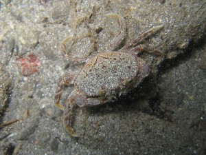
PORT ANGELES, Wash. — Anne Shaffer sits on the sandy shoreline of the Elwha River and looks around in amazement. Just two years ago, this area would have been under about 20 feet of water.

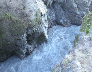
So far about 3 million cubic yards of sediment — enough to fill about 300,000 dump trucks — has been released from the giant bathtubs of sediment that formed behind the two hydroelectric dams upstream. And that’s only 16 percent of what’s expected to be delivered downstream in the next five years.

All of that sediment is already reshaping the mouth of the Elwha, which empties into the Strait of Juan de Fuca on the northern shore of Washington’s Olympic Peninsula.

The depth at the mouth of the river has changed by about 50 feet. Long, charcoal-colored sandy beaches have formed where there once only smooth, platter-sized cobblestones.

Watch video report:


“This place is like Christmas,” says Shaffer, a marine biologist and the executive director of the Coastal Watershed Institute. “Everyday you come out here and its something new.”

Shaffer is leading a team of researchers who are studying the Elwha’s nearshore area, where the river’s freshwater meets the saltwater tides. Shaffer explains that until recently this area was starved of sediment, and now a whole new ecosystem is forming. Her team is trying to find out what tiny creatures are moving in.

They’re searching for evidence that species like sand lance and surf smelt are using this area as spawning grounds. These tiny fish are a common food sources for juvenile salmon.

Sand_Lance_Surf_smelt_USGS
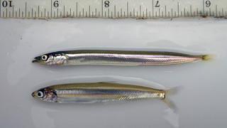
Sand lance (top) and surf smelt (bottom) by David Ayers/USGS.


Sand lance, she explained, require a very fine grain sediment in order to lay their eggs.

“We now are surrounded by the exact grain size that sand lance need to spawn,” she says.

The team scoops up bags of sand to test in the lab. So far they haven’t found evidence of sand lance spawning in this new habitat, Shaffer says. But they have found that surf smelt are spawning in areas where sandy substrate has built up.

During recent fish census surveys of the Elwha’s estuary, Shaffer’s team counted baby chum salmon in numbers they haven’t seen in years, if ever, Shaffer said. And they’ve also found a number of eulachon, a type of smelt that was once an abundant food source for coastal tribes. The eulachon is now listed as threatened under the Endangered Species Act.

“As soon as this habitat is available, these fish are using it,” Shaffer says. “None of us anticipated how quickly it would occur. I’d never seen a eulachon in the estuary before, but in the last three months, every time we survey, we see them.”

The drone of a single-engine plane causes Shaffer to look up and shield her eyes.

“I bet that’s Tom,” she says with a smile.
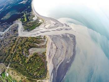
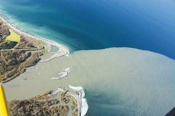
A Bird’s Eye View

Port Angeles pilot and photographer Tom Roorda has had one of the most unique perspectives during the last two and a half years while the dams have been slowly dismantled. He started taking land-survey photos of the Elwha eight years ago. Back then his photos were used to help the federal Bureau of Reclamation prepare for dam removal.

Today his jaw-dropping aerial photos capture the giant plume of sediment flowing out of the mouth of the Elwha.

“Until I started taking these pictures, no one had any idea how much sediment was coming down or how far it extended out into the strait,” Roorda said.

The flush of sediment has moved the mouth of the Elwha north by about 300 feet, creating a long skinny spit that extends into the Strait of Juan de Fuca. The area that used to serve as the Elwha’s estuary has been inundated with freshwater and a new estuary is forming downstream.

“As soon as it starts to rain that sediment gets washed down into the river and we get these big gulps of sediment coming down,” Roorda said.

This winter’s rains have continued to flush sediment downstream, so much so that the river’s flow is currently 10 times higher than normal. While all that sediment is ideal for building nearshore habitat, some worry the water will be too murky for salmon. Sediment can clog and irritate their gills and make it difficult to find food.

But Shaffer for one, isn’t concerned.

“Salmon are brilliant,” she said. “They have evolved over millenia. If they’re given a chance to acclimate to it, they will.”

The First Leap?

Today the entire length of Elwha looks like a free-flowing river. That’s because recent storms have submerged the remaining 25 or so feet of the Glines Canyon Dam.

Glines Canyon Dam 3/10/14
Glines Canyon Dam, March 10, 2014, Olympic National Park


From webcam images, it’s difficult to even identify the slope of what remains of the 210-foot spillway. This is causing some to wonder how much longer it will be before the first fish leap over the concrete barrier that remains.

It may take weeks or months, but when the first leap happens, it’s not likely to be a salmon.

“Steelhead are quite the athletes. A steelhead can leap up to 12 feet in a single jump,” said John McMillan, a NOAA biologist who is tracking fish recovery on the Elwha.

McMillan is betting on steelhead — trout that, like salmon, are born in freshwater streams before migrate to marine waters. He says he’s seen steelhead ascend a 35-foot cascading waterfall by taking a series of long leaps.

Researchers are using imaging sonar to track the different fish returning to the Elwha, and they’ve found that some steelhead have already returned to the lower Elwha, McMillan said. The bulk of the run, however, is expected to take place from April to early July, he said.

Dam deconstruction will pause May 1 to minimize disruption to the steelhead spawning season.

Removal of the Lower Elwha Dam finished in March 2012. The last of the rubble of the Glines Canyon dam is expected to be gone by September 2014.