This doc about “bomb trains” filled with crude oil will make your head explode

By Ted Alvarez, Grist


VICE News just released Bomb Trains: The Crude Gamble of Oil by Raila 23-minute-long documentary investigating the explosive oil trains that regularly run from the Bakken shale to the Pacific Northwest. That might seem a bit long for web video, but you should watch it anyway — mostly because Thomas the Terror Engine is headed to your town, but also because Jerry Bruckheimer has nothing on the terrifying explosions at the 5:09 and 6:00 marks.


Oh, and you can find out if you live near a bomb-train blast zone right here. (Spoiler alert: You probably do.)

Sea Star Disease Strikes Washington Marine Centers

July 28, 2014 | AP


PORT ANGELES, Wash. (AP) — The disease wreaking havoc on wild sea star populations on the West Coast has struck captive collections on Washington’s Olympic Peninsula.

The Peninsula Daily News reports Monday that sea stars at Port Townsend’s Marine Life Center and Feiro Marine Life Center in Port Angeles have died of the disease, known as sea star wasting.

In Port Townsend, 12 ochre stars have died, while the illness eliminated a species from the tanks in Port Angeles. Both centers pipe in ocean water for their tanks. Experts believe the disease is infectious and might be caused by bacteria or a virus.

Caretakers at the Olympic Peninsula’s marine science centers don’t intend to replace sea stars until they feel more confident they can keep them alive. They also want to avoid taking breeding adults that might be needed to replenish wild colonies.

National Park Service Awards Historic Preservation Grants to Indian Tribes, Alaska Natives, and Native Hawaiian Organizations

Source: National Park Service


WASHINGTON – National Park Service Director Jonathan B. Jarvis today announced more than $700,000 in historic preservation grants to 18 American Indian tribes and Alaskan Natives organizations.
 
“These grants help America’s first peoples in preserving significant tribal places, culture and tradition,” said National Park Service Director Jonathan B. Jarvis. “Whether used to create oral history programs, operate museums and cultural centers, or develop training and education programs, the grants help all Americans gain a greater appreciation of our nation’s rich traditions and cultures.”
 
The competitive grants can also be used to fund projects such as nominations to the National Register of Historic Places, preservation education, architectural planning, historic structure reports, community preservation plans, and bricks-and-mortar repair to buildings.
 
Congress provides these grant appropriations each year with revenue from Federal oil leases on the Outer Continental Shelf. The National Park Service administers the grants through the Historic Preservation Fund on behalf of the Secretary of the Interior.
 
For more information about the National Park Service tribal preservation programs and grants, please visit: http://www.nps.gov/tribes/Tribal_Historic_Preservation_Officers_Program.htm.
 
HISTORIC PRESERVATION FUND APPORTIONMENT TO
INDIAN TRIBES, ALASKA NATIVES, AND NATIVE HAWAIIANS
 
Ahtna Heritage Foundation (Alaska)                         $39,523
Igiugig Village Council (Alaska)                                $26,691
Native Village of Ambler (Alaska)                             $39,942
Seldovia Village Tribe, IRA (Alaska)                         $40,000
Hoopa Valley Tribe, (California)                                $40,000
Ione Band of Miwok Indians (California)                  $40,000
Sherwood Valley Rancheria Valley Band of Pomo Indians, (California)      $40,000
Kohe Malamaiam O Kanaloa(Protect Kaho’olawe Fund), (Hawaii)             $34,175
Grand Traverse Band of Ottawa and Chippewa Indians (Michigan)            $40,000
The Prairie Island Paiute Tribe (Nevada)                    $39,421
Pyramid Lake Paiute Tribe (Nevada)                           $36,902
Navajo Nation – Fort Defiance Chapter (New Mexico)      $40,000
Pueblo of Santa Ana (New Mexico)                           $38,579
Miami Tribe of Oklahoma, (Oklahoma)                      $30,925
Peori Tribe of Indians of Oklahoma (Oklahoma)        $48,000
Seminole Nation of Oklahoma (Oklahoma)               $40,000
Seneca-Cayuga Tribe of Oklahoma, (Oklahoma)      $59,692
Confederated tribes of Coos, Lower Umpqua,
     and Siuslaw Indians (Oregon)                               $39,066
 
TOTAL                                                                      $712,916
 

Drought Starting To Kill Salmon In Klamath Basin

Low warm water conditions from the drought are starting to kill salmon in the Klamath Basin. | credit: U.S. Fish and Wildlife Service/Flickr

By: Associated Press


Low warm water conditions from the drought are starting to kill salmon in northern California and southern Oregon’s Klamath Basin — the site of a massive fish kill in 2002.

Sara Borok of the California Department of Fish and Wildlife said a survey of the Salmon River on Wednesday found 55 dead adult salmon and more dead juveniles than would be expected this time of year. The reason is low and warm water related to the drought.

Fisheries officials do not want see a repeat of 2002, but there is little to do but pray for rain. Even in the Klamath River, which has dams to store water, there is little available for extra releases.

The Salmon River is a tributary of the Klamath River.

Amazon oil spill has killed tons of fish, sickened native people

by Barbara Fraser on July 23, 2014, IC Magazine


CUNINICO, Peru – On the last day of June, Roger Mangía Vega watched an oil slick and a mass of dead fish float past this tiny Kukama Indian community and into the Marañón River, a major tributary of the Amazon.

Community leaders called the emergency number for Petroperu, the state-run operator of the 845-kilometer pipeline that pumps crude oil from the Amazon over the Andes Mountains to a port on Peru’s northern coast.
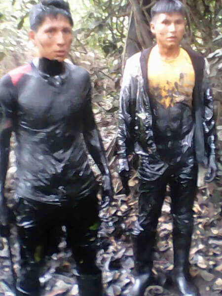
 

Local men were covered with oil after being hired to find the leak in the submerged pipeline. (Photo: Municipality of Urarinas)

Local men were covered with oil after being hired to find the leak in the submerged pipeline. (Photo: Municipality of Urarinas)

By late afternoon, Mangía and a handful of his neighbors – contracted by the company and wearing only ordinary clothing – were up to their necks in oily water, searching for a leak in the pipe. Villagers, who depend on fish for subsistence and income, estimated that they had seen between two and seven tons of dead fish floating in lagoons and littering the landscape.

“It was the most horrible thing I’ve seen in my life – the amount of oil, the huge number of dead fish and my Kukama brothers working without the necessary protection,” said Ander Ordóñez Mozombite, an environmental monitor for an indigenous community group called Acodecospat who visited the site a few days later.
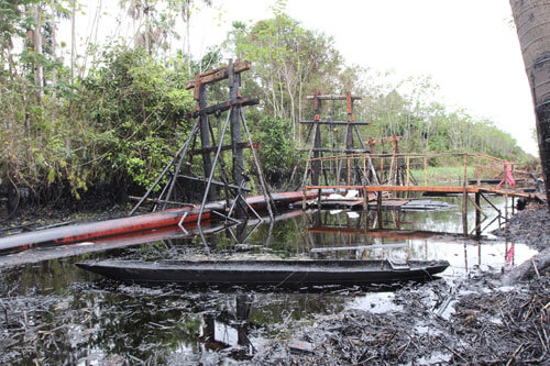
 

Scaffolding holds a broken section of the oil pipeline. (Photo: Barbara Fraser)

Scaffolding holds a broken section of the oil pipeline. (Photo: Barbara Fraser)

This rupture of Peru’s 39-year-old northern crude oil pipeline has terrified Kukama villagers along the Marañón River. People’s complaints of nausea and skin rashes are aggravated by nervousness about eating the fish, concerns about their lost income and fears that oil will spread throughout the tropical forest and lakes when seasonal flooding begins in November. Cuninico, a village of wooden, stilt-raised, palm-thatched houses, is home to about 130 families but several hundred families in other communities also fish nearby.

Three weeks after they discovered the spill, the villagers still have more questions than answers about the impacts.

“It sounds like an environmental debacle for the people and the ecosystem,” said David Abramson, deputy director of the National Center of Disaster Preparedness at Columbia University’s Earth Institute in New York.

“There is a need for public health and environmental monitoring at a minimum of four levels – water, fish, vegetation and the population,” he said.
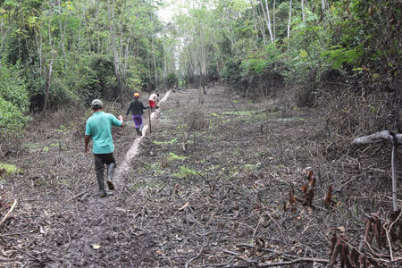
 

Kukama community leaders walk along the pipeline through a marshy area. (Photo: Barbara Fraser)

Kukama community leaders walk along the pipeline through a marshy area. (Photo: Barbara Fraser)

Company officials at Petroperu did not return phone calls and emails seeking comment.

Government officials have not officially announced how much crude oil spilled. However, in a radio interview, Energy and Mines Minister Eleodoro Mayorga mentioned 2,000 barrels, which is 84,000 gallons.

Indigenous leaders noted that the pipeline, which began operating again July 12 after the repairs, has a history of leaks.

Leaders of at least four neighboring communities said masses of dead fish appeared in lagoons and streams in the week before the oil spill was reported, indicating that it could have been leaking for days before it was spotted.

Even fish that escaped the worst of the spill could be poisoned, experts said. Fishermen who traveled an hour or two up the Urituyacu River, a tributary of the Marañón, in search of a catch unaffected by the spill returned with fish that they said tasted of oil.

Some Amazonian fish migrate long distances, and ongoing monitoring will be important for determining how fisheries recover, said Diana Papoulias, a fish biologist with E-Tech International, a New Mexico-based engineering firm that advises indigenous Peruvian communities on oil-related issues.

Key concerns include polycyclic aromatic hydrocarbons (PAHs), which are classified as probable human carcinogens and can cause skin, liver and immune system problems, according to the U.S. Centers for Disease Control and Prevention. Exposure to PAHs in the womb has been linked to effects on children’s brain development, including learning and behavioral changes.

“The rule of thumb is that during the spill it’s a horrible mess, and two or three years later it’s hard to find evidence.” –Edward Overton, Louisiana State University For pregnant women, the fish become a “double-edged sword,” Abramson said. “They need that protein source to enhance the neurological development of the fetus, but at the same time, you don’t want them ingesting things that have unknown impacts.”

Mothers said children and adults in their families are suffering from stomachaches, nausea, vomiting and dizziness, and small children have skin rashes after bathing in the rivers.

In this part of the Marañón valley, the nearest health center is more than an hour away by boat and does not have a doctor.

The government’s Environmental Evaluation and Oversight Agency (Organismo de Evaluación y Fiscalización Ambiental, OEFA) has taken no samples of fish tissue for testing, according to Delia Morales, the agency’s assistant director of inspection.

Much of the oil settled in pools along the pipeline during the flood season, creating a viscous soup where dying fish flopped weakly. Government officials said damage was limited to a 700-meter stretch along the pipeline. The ground and tree trunks in the forest on both sides of the pipeline were also stained with oil, in a swath local residents estimated at up to 300 meters wide. When that area begins to flood again in November, villagers fear that contamination could spread.
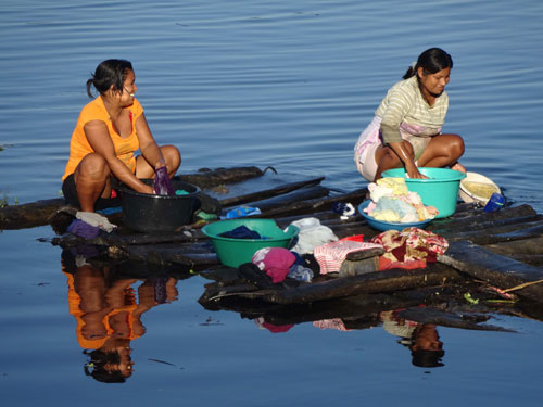
 

Kukama women wash clothes in the river that also provides water for drinking, cooking and bathing. (Photo: Radio Ucamara)

Kukama women wash clothes in the river that also provides water for drinking, cooking and bathing. (Photo: Radio Ucamara)

Petroperu hired men from the village of Cuninico to find the leak and raise the pipeline out of the canal to repair it. Several of the men said they were up to their necks in oily water, working in T-shirts and pants or stripped to their underwear. They said they received protective gear only when a Peruvian TV crew arrived more than two weeks later. The July 20 newscast led to a shakeup in Petroperu’s leadership.

Meanwhile, the workers’ wives wash their clothes in the Marañón River, squatting on rafts moored along the bank. Besides being the only transportation route in the area, the river is the source of water for drinking, cooking, bathing and washing.

Within a week after the spill, the local fish market had dried up. Women who normally sold 10 to 20 kilos of fish a day said their usual buyers shunned them. Children in Cuninico told a reporter from Radio Ucamara, a local radio station, that fish had disappeared from the family table and they were eating mainly rice and cassava, a root.

Abramson said the villagers’ mental health can be undermined by poor diet, income loss and conflicts between community members.

The pipeline has been repaired and the oil is flowing to the port again, but the long-term impacts of the spill are uncertain.
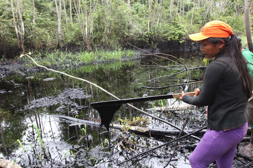
 

Glob of oil drips from a stick dipped into a pool beside the submerged pipeline. (Photo: Barbara Fraser)

Glob of oil drips from a stick dipped into a pool beside the submerged pipeline. (Photo: Barbara Fraser)

Light and bacteria help break down oil naturally, said Edward Overton, a chemistry professor in Louisiana State University’s Department of Environmental Studies who has studied the Deepwater Horizon oil spill in the Gulf of Mexico. Volatile substances in the oil, which dissolve readily in water, could have caused the fish kills if the pipeline had been leaking for a time before the spill was reported, he said.

“The rule of thumb is that during the spill it’s a horrible mess, and two or three years later it’s hard to find evidence,” Overton said.

But that may not be the case in Amazonian wetlands, where clay soil and high water limit the oxygen available to oil-eating microbes, said Ricardo Segovia, a hydrogeologist with E-Tech International.

The government’s environmental agency is expected to issue its report on the spill by the end of this month and could levy fines, Morales said.

Villagers are waiting to see whether the government will sanction its own pipeline operation and pay damages.

“It sounds as though the state is in a precarious position,” Abramson said. “It [the government of Peru] has to monitor and assure the health and well-being of the population, but it may be one of the agents that is liable [for the spill]. They have to monitor themselves and decide what is fair and equitable.”

EPA awards over $756,000 to research coastal climate change impacts on Swinomish Indian Tribal Community

img_NWSwinomish_01

Source: EPA


(Seattle—July 23, 2014) The U.S. Environmental Protection Agency announced today it is awarding over $756,000 to the Swinomish Indian Tribal Community to research coastal climate impacts to traditional foods, cultural sites and tribal community health and well-being.
The combination of sea level rise, wave impacts, and shoreline development will change coastal ecosystems that support Swinomish first foods and place-based relationships, which in turn impacts community health and well-being.

The funds will be used to:
· Develop a model showing projected coastal erosion due to sea-level rise, storm surge, and wave energy through Year 2100 on the shores of the Swinomish Reservation
· Map the vulnerability of Swinomish coastal ecosystem habitats of first foods and culturally significant sites
· Support the Swinomish Climate Change Initiative
· Create educational and outreach tools for Swinomish community members and Coast Salish communities
· Assess research results and develop adaptive strategies
EPA funds research focused on tribal communities through the Science to Achieve Results program. Because many tribes rely on natural resources, it is essential for tribal-focused research to identify possible environmental health risks and the most efficient methods of avoiding or addressing these risks.

More information about the grants awarded: http://cfpub.epa.gov/ncer_abstracts/index.cfm/fuseaction/recipients.display/rfa_id/569/records_per_page/ALL

More information on Tribal Environmental Health Research: http://epa.gov/ncer/tribalresearch/

Study: Coal Project Would Help One Puget Sound County But Others Would Pay

A council of governments in the central Puget Sound region commissioned a study by an independent consultant. It concluded that economic benefits of a proposed coal export terminal would be concentrated in Whatcom County, where it would be built. | credit: Katie Campbell


By: Ashley Ahearn, OPB


If it’s built, the coal-exporting Gateway Pacific Terminal will create more than two thousand jobs in Whatcom County during construction and several hundred permanent jobs once it’s operational.

The outlook for the the central Puget Sound region isn’t as optimistic, according to a new economic study from the Puget Sound Regional Council issued Thursday.

“It’s an economic model that creates very few jobs, certainly very, very few in the region … and has grave consequences for mobility here in Puget Sound,” King County Executive Dow Constantine said in response to the study.

Low income communities in Kent and Seattle will be disproportionately affected by the coal train traffic, according to the study. Residential and commercial properties along coal train routes could decline as much as $282.3 million and $133 million, respectively.

“Communities along the rail lines will face a host of negative impacts, most of those are bad for business, with very little positive economic development from this particular activity and there’s no assurance the costs of upgrades won’t fall to us as well,” Constantine said.

With a capacity to export roughly 54 million metric tons of coal per year, the terminal would be the largest facility of its kind on the west coast. It would also have implications for the state’s rail system unlike any of the region’s other coal export proposals.

If BNSF Railway is unable to increase capacity on its main north-south line through Puget Sound, according to the study, the added 18 coal trains per day to and from Cherry Point could cause delays that hurt export-related jobs, stunt port growth and squeeze out current commodities and passenger rail.


Anticipated delays caused by Gateway Pacific Terminal train traffic
A new study commissioned by the Puget Sound Research Council anticipates the 18 additional coal trains per day to and from the proposed Gateway Pacific Terminal would create delays at rail crossings.’


The Gateway Pacific project would increase delays at rail crossings between 38 and 85 minutes, according to the study. Those delays could be nearly three hours by 2035 without rail system updates. Rail traffic is expected to increase regardless of whether the terminal becomes operational, and the study did not account for the simultaneous increase in rail traffic of crude oil, which has also caused delays on the region’s rail lines.

Terry Finn, a retired BNSF Railway lobbyist who serves on one of the council’s advisory boards, said in a letter to the council that its study was the latest attempt by opponents to use scare tactics to stop the coal project.

The completed terminal could force an upgrade of existing rail lines, which would instead boost the region’s economy, according to the study.

A business coalition formed to advocate for coal exports called the Alliance for Northwest Jobs & Exports issued a statement in response to the report.

It said that the report’s overall conclusions are not supported by the facts and that “greatly exaggerated costs projected in the study just don’t add up.”

Kathryn Stenger, a spokeswoman for the alliance, said in an email that other studies have concluded that the Gateway Pacific Terminal would economically benefit the entire region. The Washington State Farm Bureau, Association of Washington Business, and Washington State Labor Council have all endorsed Gateway Pacific, she said.

A separate economic study done for the Washington Farm Bureau in 2013 concluded coal terminals would result in lower costs and new markets for other Washington businesses.

BNSF Railway says it is investing approximately $235 million in Washington state this year to expand rail capacity and to replace and maintain network infrastructure.

There are 77 crossings in cities and towns in the Puget Sound area. Kent Mayor Suzette Cook said they present a safety issue as train traffic increases.

“At grade crossings are also a major problem with deaths. We’ve had several deaths occur on our tracks within the last year,” Cook said. “Cities are not in a position to shoulder the cost because other than avoidance of tragedy, the benefits are not there.”

How a town in Maine is blocking an Exxon tar-sands pipeline

By Roger Drouin, Grist


tar sands protestors in Maine
350.org
 

Citizens trying to stop the piping of tar-sands oil through their community wore blue “Clear Skies” shirts at a city council meeting in South Portland, Maine, this week. But they might as well have been wearing boxing gloves. The small city struck a mighty blow against Canadian tar-sands extraction.

“It’s been a long fight,” said resident Andy Jones after a 6-1 city council vote on Monday to approve the Clear Skies Ordinance, which will block the loading of heavy tar-sands bitumen onto tankers at the city’s port.

The measure is intended to stop ExxonMobil and partner companies from bringing Albertan tar-sands oil east through an aging pipeline network to the city’s waterfront. Currently, the pipeline transports conventional oil west from Portland to Canada; the companies want to reverse its flow.

After an intensely debated, year-and-a-half battle, the South Portland City Council on Monday sided with residents like Jones who don’t want their city to end up as a new “international hub” for the export of tar-sands oil.

South Portland city council meeting
Dan Wood
Proponents of the Clear Skies ordinance, wearing blue, packed a South Portland city council meeting on July 9.
 

“The message to the tar sands industry is: ‘Don’t be counting your chickens yet,’” said Dylan Voorhees, clean energy director for the Natural Resources Council of Maine. “There is a pattern of communities saying ‘no’ to the threat of tar-sands oil.”

A clear signal

The ordinance could have global implications. The Canadian government expects the nation’s oil industry to be producing 4 million to 6 million barrels of tar-sands bitumen a day within a few years, and it’s pinning its hopes on somehow getting all that oil to coastal ports, said Richard Kuprewicz, president of Washington-based pipeline safety consulting firm Accufacts Inc. Indeed, a recent report from the International Energy Agency found that the industry needs export pipelines in order for its boom to continue.

South Portland’s move is just the latest setback for plans to pipe the bitumen out to international markets. Another big hurdle is the long delay over the Keystone XL pipeline. And in Canada, pipeline plans have met with opposition from indigenous peoples (known as First Nations), who are taking the lead to stop projects like the Enbridge Northern Gateway tar-sands pipeline through British Columbia.

Now, there is a clear signal that communities along the U.S. East Coast will fight tar-sands expansion too.

“Do not under estimate the power of a local government,” said Kuprewicz.

“A lot of perseverance”

In early 2013, residents formed Protect South Portland to try to stop the Portland-Montreal Pipeline reversal. They put an initiative on the November 2013 ballot to block the project, but it lost narrowly at the polls.

So the city council took up the cause. In December of last year, the council voted to impose a six-month moratorium on shipping tar-sands oil out through its port. Then a council-appointed committee crafted the Clear Skies Ordinance to permanently block tar-sands shipments, which is what the council officially approved this week. The law also changes zoning rules to block the construction of twin smokestacks that would be needed to burn off bitumen-thinning chemicals before the oil could be shipped out.

Over the past few months, concerned residents met in homes and Protect South Portland grew. Meanwhile, the group Energy Citizens, backed by the American Petroleum Institute, the oil industry’s largest trade group, ran ads that said “It’s just oil. From Canada.” The oil companies hired a number of lawyers and brought public relations firms on board.

Protect South Portland spokeswoman MJ Ferrier estimates that the grassroots group was outspent by at least 6 to 1.

So how did residents win over Big Oil? “A lot of perseverance and a lot of community engagement,” Voorhees said.

After the vote, supporters of the ordinance went to a local bar, and “we raised our glasses,” Jones told Grist.

Cautious celebration

But while local activists are celebrating this week’s win, they know “this is not the end,” said Jones.

South Portland Councilor Tom Blake, who’s been a champion of the effort to protect the city from tar sands, said a legal challenge seems imminent, by either Portland Pipe Line Corp., a subsidiary of ExxonMobil, or by the Canadian government. Blake had this message for the oil company and Canadian officials Monday evening: “This ordinance is the will of the people,” he said. “Do not spend millions of dollars and force the city of South Portland to do the same.”

But the oil interests are unlikely to heed his warning.

Tom Hardison, vice president of Portland Pipe Line, told reporters that the city had made a rush decision and bowed to environmental “off-oil extremists.” He added that the zoning changes amounted to a “job-killing ordinance” that prevents the city’s port from adapting to meet the energy needs of North America.

Matthew Manahan, attorney for Portland Pipe Line, told the city council before the vote that its ordinance is “illegal” and “would clearly be preempted by federal and state law.”

“The council is ignoring the law” and “ignoring science,” the lawyer added.

Air and water worries

Like the process of extracting tar-sands oil, the process of transporting it takes a huge toll on the environment. Before the heavy, almost-solid bitumen can be sent through pipelines, it has to be thinned with a concoction of liquid natural gas and other hydrocarbons. And then before it can be loaded onto ships, that concoction has to be burned off. ExxonMobil currently holds permits to build two smokestacks on South Portland’s waterfront that would do the burning.

Ferrier, a retired psychologist and a nun, joined Protect South Portland largely out of concern for what the oil companies’ plans would do to air quality in an area that has already received a “C” for ozone pollution from the American Lung Association. The proposed smokestacks would emit volatile organic compounds (VOCs). “We know there is benzene in it, a known carcinogen,” said Ferrier.

Resident Andrew Parker had similar concerns. “Tonight is about children,” he said at Monday’s city council meeting. “The oil company will put poison in the air, that is a fact.”

For Mayor Gerard Jalbert, who also sits on the city council and voted in support of the ordinance, it came down to concerns about water quality. The risk of water contamination in the case of a spill far outweighed the nebulous claims about job creation.

“When I look at the economic benefit, which no seems to be able to detail, the risk seems to outweigh the benefit,” Jalbert told Grist.

The easternmost 236-mile stretch of pipeline crosses some of the most sensitive ecosystems in Maine, including the Androscoggin River, the pristine Crooked River, and Sebago Lake, which supplies drinking water for 15 percent of the state’s population.

Blake, the council member, is worried that using old pipes to transport heavy bitumen could lead to a spill like the one that happened in Mayflower, Ark., in March 2013, when an ExxonMobil pipeline built in the 1940s ruptured and spilled hundreds of thousands of gallons of tar-sands oil.

Saying “no” to tar sands is part of a bigger shift to a greener future in South Portland, Blake added. “Being a community that has been heavily dependent on petroleum, this turns a tide,” the councilor said.

He pointed to a new electric-car charging station at the city’s community center and potential plans to build a solar farm on an old landfill as steps toward a sustainable future. “I think we are starting to walk the talk,” Blake said.

Roger Drouin is a freelance journalist who covers environmental issues. When he’s not reporting or writing, he is out getting almost lost in the woods. He blogs at rogersoutdoorblog.com.

New Report: Oso Landslide Rooted In Long History Of Slides

A photo taken immediately after the March 22 slide that killed 43 people and destroyed dozens of homes in Oso, Washington. A new scientific reports says a history of landslides and a huge volume of precipitation were big contributors to the slide. | credit: Washington Department of Transportation


By: Ashley Ahearn, KUOW

SEATTLE — Scientists have concluded that rain, groundwater seepage and a long history of big landslides likely contributed to the massive landslide of March 22 that killed 43 people and destroyed dozens of homes near Oso, Washington.

Those findings came out Tuesday, the result of a scientific team’s rapid-fire assessment of geology and localized factors.

Joe Wartman, a University of Washington associate professor of civil and environmental engineering and a co-lead author of the study, said rainfall very likely played a key role in the slide.

“It mobilized as the water entered the landslide mass. It raised the water pressure in that mass,” Wartman said, “And as a result the landslide mass lost its strength and it became a fluidized mass of earth and material.”

The U.S. Geological Survey estimates that 7.6 million cubic meters of earth slid down across the Stillaguamish River, spreading out for more than a kilometer.

The researchers also looked further back in history, reviewing evidence from a number of large landslides in the Stillaguamish Valley around Oso during the previous 6,000 years. The team estimated that, based on a review of carbon dating and maps of 15 similar historic landslides nearby, slides such as the March event have happened in the same area as often as every 400 to 1,500 years historically.

“The real different thing about that particular spot was how much it had failed in the very recent past,” said Dave Montgomery, a geomorphologist with the University of Washington and co-author of the report. “It had been chewed on a lot by prior failures.”

Screen Shot 2014-07-22 at 3.07.16 PM
A 2003 lidar map of ground conditions where the Oso slide occurred.


The report authors said the landslide occurred in two phases. The first slope failure was a repeat of previous slides that had been documented as far back as the 1950s at that site. The most recent one to contribute to the March slide took place in 2006.

The second phase of the March 22 event tapped into a much deeper landslide history at the site.

“You have the really big ones from thousands of years ago,” Montgomery said, “But why did the piece of the slope fail that did? It was different from some other areas up and down the valley due to the history of failure in recent decades, which exacerbated the stability problem.”

The report raised a question that was brought up in the immediate aftermath of the slide: what role did logging play? But the authors said that they were “not in a position to answer the question of what degree forest practices contributed to this slide.” Any conclusions would require further modeling and were beyond the scope of this four-day reconnaissance effort, they said.

Logging can contribute to weakened root strength, allowing hillsides to slough off in heavy rain. But Montgomery said the team was pretty comfortable ruling out that idea because the slide was too big and roots would have been too thin to make a difference in preventing the massive amount of earth from loosening.

Another potential connection to logging is from the removal of trees that would otherwise have absorbed some of the precipitation, preventing it from seeping deep into the soil and loosening it. Groundwater seems to have been a key contributor to the destabilization of the slope near Oso, the report authors concluded. Montgomery said the team saw seeps of water coming into the exposed face, or scarp, of the landslide from neighboring creek basins to the east.

“We located five or six groundwater seeps where water is coming out of the wall of the slide and forming a little stream that is running across the scar,” Montgomery said. That stream could have destabilized the earth far below the surface of the slide, contributing to its size and extensive runout zone.

The authors concluded that methods to identify and predict potential landslide runout zones need to be revisited and re-evaluated. The use of LIDAR imagery could also provide a great deal of assistance in gathering historic evidence that landslides of this magnitude have run across the valley before, said Jeff Keaton, a principal engineering geologist with AMEC Americas, who contributed to the report.

“That would be a really helpful step in understanding how widespread this kind of process actually is,” he said.

But there’s more digging to be done, literally, said Joe Wartman.

“The hole we have at this point is understanding what was going on underneath the ground surface,” Wartman said. “I think the next big thing is drilling holes into that landslide and the nearby vicinity to get an understanding of what is underneath that large landslide.”

The authors called for further modeling in order to better understand to what degree logging or the Stillaguamish River, which was eating away at the toe of the slope, may have contributed to the catastrophic slide.

The USGS and others will be conducting field research in the coming months. You can read the full report here.

Canoe Journey Message: Protect Our Fragile Environment

Tracy Rector/Longhouse MediaThe Heiltsuk First Nation is hosting 31 canoes from Pacific Northwest indigenous nations. That number was provided by the manager of the Paddle to Bella Bella Facebook page. Canoes arrived July 13; the week of cultural celebration continues through July 19.
Tracy Rector/Longhouse Media
The Heiltsuk First Nation is hosting 31 canoes from Pacific Northwest indigenous nations. That number was provided by the manager of the Paddle to Bella Bella Facebook page. Canoes arrived July 13; the week of cultural celebration continues through July 19.


Richard Walker, Indian Country Today


En route to the territory of the Heiltsuk First Nation, pullers in the 2014 Canoe Journey traveled through territory so beautiful it will be impossible to forget: Rugged, forested coastlines; island-dotted straits and narrow, glacier-carved passages; through Johnstone Strait, home of the largest resident pod of orcas in the world, and along the shores of the Great Bear Rainforest, one of the largest remaining tracts of unspoiled temperate rainforest left in the world.

They also traveled waters that are increasingly polluted and under threat.

Pullers traveled the marine highways of their ancestors, past Victoria, British Columbia, which dumps filtered, untreated sewage into the Salish Sea. They traveled the routes that U.S. energy company Kinder Morgan plans to use to ship 400 tanker loads of heavy crude oil each year.

Canoes traveling from the north passed the inlets leading to Kitimat, where heavy crude from Enbridge Inc.’s Northern Gateway pipeline would be loaded onto tankers bound for Asia, a project that Canada approved on June 17.

RELATED: First Nations Challenge Enbridge’s Northern Gateway Pipeline in Court

Canoes from the Lummi Nation near Bellingham passed Cherry Point, a sacred and environmentally sensitive area where Gateway Pacific proposes a coal train terminal; early site preparation was done without permits and desecrated ancestral burials.

RELATED: Lummi Nation Officially Opposes Coal Export Terminal in Letter to Army Corps of Engineers

Young activist Ta’kaiya Blaney of the Sliammon First Nation sang of her fears of potential environmental damage to come in her song, “Shallow Waters”:

“Come with me to the emerald sea / Where black gold spills into my ocean dreams.

“Nothing to be found, no life is around / It’s just the sound of mourning in the air.”

RELATED: Young Sliammon Actor/Singer Campaigns Against Pipeline

Canoes from Northwest indigenous nations arrived in Bella Bella, British Columbia on July 13; the gathering continues until July 19 with cultural celebrations, a rally against Enbridge’s Northern Gateway pipeline, and an indigenous economic summit. The ceremonies are being livestreamed online at Tribal Canoe Journeys 2014 :: Qatuwas Bella Bella.

Mike Williams Sr., chief of the Yupiit Nation and member of the board of First Stewards, noted that the Canoe Journey route calls attention to the fragile environment that’s at stake. First Stewards, an indigenous environmental advocacy group, will host a symposium on “Sustainability, Climate Change & Traditional Places” from July 21–23 in Washington, D.C.

“The Canoe Journey is a really big statement to us to hang onto our culture and our way of life, and to bind people together,” said Williams, who is also a well-known musher. “In the Iditarod, there are pristine places but there are also old mining towns [on the route] where we’re told not to drink the water.”

The parallels between the water issues encountered on the Iditarod and the Canoe Journey are unmistakable, he added.

“In the Canoe Journey, there are pristine waters and there are waters that contains toxic substances,” Williams said. “There’s oil and the continuous leaking of pipelines. It happens.”

Not only does it happen, but it does not go away. Prince William Sound has never totally recovered from the Exxon Valdez oil spill, Williams said. Likewise, he added, if the Northern Gateway pipeline, the coal trains and increased shipping come to fruition, an environmental disaster is inevitable.

“It’s going to happen,” Williams said. “There has to be total, thoughtful conversation for everyone—consider all the possible impacts. And there has to be meaningful consultation with the tribes. They have to weigh in on that. We’ve got to make it 100 percent fail-safe or don’t do it.”


The Heiltsuk First Nation's hosting of the 2014 Canoe Journey included a rally against the Enbridge pipeline. Canoes arrived in Bella Bella, B.C., on July 13; the week of cultural celebration continues through July 19. (Photo: Tracy Rector/Longhouse Media)
The Heiltsuk First Nation’s hosting of the 2014 Canoe Journey included a rally against the Enbridge pipeline. Canoes arrived in Bella Bella, B.C., on July 13; the week of cultural celebration continues through July 19. (Photo: Tracy Rector/Longhouse Media)


State Senator John McCoy, D-Tulalip, is a citizen of the Tulalip Tribes. He is the ranking member of the Senate Energy, Environment & Telecommunications Committee, which focuses on such issues as climate change, water quality, toxic chemical use reduction and cleanup, and management of storm water and wastewater.

“I think the message is, pollution is occurring everywhere,” McCoy said of the takeaway from the Canoe Journey. “It’s a worldwide problem, and it needs to be addressed. If we keep polluting our water, we’re going to be in big trouble. Water is the essence of life.”

Canoes were underway for Bella Bella on July 9 as Governor Jay Inslee announced that he wants to increase the recommended fish-consumption rate in the state from 6.5 grams to 175 grams a day—that’s good news for indigenous peoples, for whom fish is important culturally, spiritually and as a food. But for 175 grams of fish to be considered safe to eat, businesses that pollute will have to conform to tougher pollution control standards.

RELATED: New Fish Consumption Guidelines More Political Than Scientific, Northwest Tribes Say

Inslee’s plan for how toxic substances will be controlled in expected in December. It will require legislation, McCoy said.

Jewell James is coordinator of the Lummi Treaty Protection Task Force and a leader in the effort to prevent a coal train terminal from being built at Cherry Point, a sacred area for the Lummi people and an important spawning ground for herring, an important food for salmon.

James said environmental degradation is just part of a series of historical traumas set upon Indigenous Peoples: First, the diseases that came after contact; then the treaty era and the relocation to reservations; then the cultural and spiritual oppression of the boarding school era, and then the termination era.

“Yet we continue to exist,” James said. And the Canoe Journey, now in its 23rd year, has helped “revitalize and breathe new life into our cultural knowledge” given that journey gatherings are venues for the passing down of stories about how the ancestors lived in and cared for the environment that sustained them.

RELATED: 10 Traditional Foods You Might Enjoy During a Canoe Journey

James hopes people on the Canoe Journey connect with and carry on those stories and values.

“There are messages in those stories,” he said. “And within those stories there are sacred symbols that mean something—that you have to be careful with what you do, and others have to be careful with what they do, to Mother Earth.”


Read more at http://indiancountrytodaymedianetwork.com/2014/07/17/canoe-journey-message-protect-our-fragile-environment-155904?page=0%2C1