DOT adds webcam for Skagit River bridge construction

WSDOT Skagit River Bridge live webcam
Published: May 30, 2013
The Bellingham Herald   

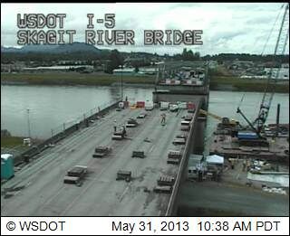
MOUNT VERNON, Wash. — Washington Department of Transportation officials have installed a webcam at the site of the collapsed Interstate 5 bridge on the Skagit River so residents can monitor the progress on repairing it.

Nearly all the materials for a temporary bridge have arrived at the site and DOT hopes to meet Gov. Jay Inslee’s goal of spanning a collapsed section by mid-June, officials said. The National Transportation Safety Board is still finishing its site investigation, The Skagit Valley Herald reported.

A section of the bridge collapsed May 23 after a girder was struck by an oversize load on a truck. Traffic currently is detoured through Mount Vernon and Burlington

.A temporary bridge will replace the 160-foot section that fell into the water. That will reopen two lanes in each direction. A permanent replacement this fall should restore the bridge.

To get to the DOT webpage that also includes traffic cameras for the George Hopper Road exit and Highway 20, click here. The webcams should automatically reload every 2 minutes, DOT said.

Increased congestion at Marysville/Tulalip I-5 interchange May 7-10

May 6, 2013 · 2:34 PM
Arington Times Staff

MARYSVILLE — Drivers who use the Interstate 5 off-ramps to Fourth Street in Marysville and Marine View Drive in Tulalip may experience increased congestion beginning the morning of Tuesday, May 7.

The Tulalip Tribes are working on a water line project on Marine View Drive just west of I-5. The project will reduce Marine View Drive at 31st Avenue NE to one lane in each direction around-the-clock from 9 a.m. on Tuesday, May 7, through 8 p.m. on Friday, May 10.

Drivers should allow extra time or consider using alternate routes between 11 a.m. and 7 p.m. on each of those days, when 900 cars per hour travel west on Marine View Drive. Backups could affect the northbound and southbound I-5 off-ramps to Fourth Street.

Washington State Department of Transportation traffic engineers will monitor the ramps throughout the closure, and adjust the interchange signals as needed. The overhead message sign on northbound I-5 near Everett will also be used to alert drivers to congestion at the interchange.

Drivers can use one of WSDOT’s many travel resources, including the Seattle area traffic map, with its Marysville-area cameras, and @WSDOT_traffic on Twitter.