Feds advance plan to kill 3,603 barred owls in Pacific Northwes

A barred owl is seen near Index, Wash. The federal government is considering killing some of the owls in the Pacific Northwest to aid the smaller northern spotted owl in the area. (Barton Glasser / Associated Press)

By John M. Glionna, Los Angeles Times

SAN FRANCISCO — Federal wildlife officials have moved one step closer to their plan to play referee in a habitat supremacy contest that has pitted two species of owl against one another in the forests of the Pacific Northwest.

On Tuesday, the U.S. Fish and Wildlife Service released a final environmental review of an experiment planned in three states to see if killing barred owls will assist the northern spotted owls, which are threatened with extinction after a major loss of territory since the 1970s.

The agency’s preferred course of action calls for killing 3,603 barred owls in four study areas in Oregon, Washington and Northern California over the next four years. At a cost of $3 million, the plan requires a special permit under the Migratory Bird Treaty Act, which prohibits killing non-game birds.

“It’s a fair assessment to say that going after the barred owls is the plan we’d prefer to pursue,” Robin Bown, a federal wildlife biologist, told the Los Angeles Times.

The agency began evaluating alternatives in 2009, gathering public comment and consulting ethicists, focus groups and conduction scientific studies.

It will issue a final decision on the plan in 30 days.

Animal activists have blasted the federal plan, saying the government should stay out of the fray and let the more dominant bird prevail, as nature intended.

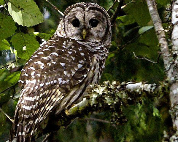
The northern spotted owl is at the center of an ongoing battle between woodcutters and environmentalists across the Pacific Northwest. Because of its dwindling numbers, the little bird is listed as a threatened species by the federal government and in Washington, Oregon and California, Bown said.

On Tuesday, the timber industry criticized the barred owl harvest.

“Shooting a few isolated areas of barred owl isn’t going to help us as forest managers, nor is it going to help the forest be protected from wildfires, and catastrophic wildfire is one of the big impediments to spotted owl recovery,” Tom Partin, president of the American Forest Resource Council, a timber industry group, told the Associated Press.

Bown disagreed.

“To people who say to me that we should leave those owls alone, my response is that ‘So you’re accepting the extinction of the spotted owl? That’s OK?’”

Bown told The Times there have been several mischaracterizations of the federal plan.

“We’re not sending public hunters into the woods to declare open season on the barred owl. This is a controlled experiment, using folks who are trained and skilled at animal removal. Our goal in this experiment is twofold: Will moving barred owls help the spotted owl population to recover? And can we use removal of barred owls as a management tool?”

Unless barred owls are brought under control, the spotted owl in coming decades might disappear from Washington’s northern Cascade Range and Oregon’s Coast Range, where the barred owl incursion has been greatest, Bown said.

“In our projected study areas, the removal would represent a very small percentage of the barred owls,” she said. “We’re also taking steps to mitigate habitat threats to the spotted owls, such as large-scale fires and timber harvests.”

Barred owls are bigger and more aggressive than the northern spotted variety. Native to the East Coast, they began working their way across the Great Plains in the early 1900s, driven west by human development. By the 1970s, the species had spread to the West Coast, where their numbers have multiplied.

In some areas of their range, northern spotted owls are outnumbered 5-to-1 by barred owls.

“While some people just feel we should leave things alone, we want to take a small step at a resolution with this experiment,” Bown told The Times.

“After all, humans had a hand in getting the barred owl here in the northwest.”

Cruise to Set Sail to Investigate Ocean Acidification

NOAA Ship Fairweather in the Gulf of Alaska with namesake Mt. Fairweather.Credit: NOAA
NOAA Ship Fairweather in the Gulf of Alaska with namesake Mt. Fairweather.
Credit: NOAA

By Douglas Main, Staff Writer for LiveScience

July 25, 2013 06:01pm ET

The waters off the Pacific Northwest are becoming more acidic, making life more difficult for the animals that live there, especially oysters and the approximately 3,200 people employed in the shellfish industry.

Researchers from the National Oceanographic and Atmospheric Administration (NOAA) will set sail Monday (July 29) on a monthlong research cruise off the U.S. and Canadian West Coast to see how ocean acidification is affecting the chemistry of the ocean waters and the area’s sea life.

Ocean acidification occurs when greenhouse-gas emissions cause carbon dioxide to accumulate in the atmosphere and become dissolved in sea water, changing the water’s chemistry and making it more difficult for coral, shellfish and other animals to form hard shells. Carbon dioxide creates carbonic acid when dispersed in water. This can dissolve carbonate, the prime component in corals and oysters’ shells.

The world’s oceans are 30 percent more acidic than they were before the Industrial Revolution, scientists estimate.

This cruise follows up on a similar effort in 2007 that supplied “jaw-dropping” data on how much ocean acidification was hurting oysters, said Brad Warren, director of the Global Ocean Health Partnership, at a news conference today (July 25). (The partnership is an alliance of governments, private groups and international organizations.)

That expedition linked more acidic waters to huge declines in oyster hatcheries, where oysters are bred, Warren said. Oyster farms rely ona fresh stock of oysters each year to remain economically viable.

When the data came in from that cruise, it was “a huge wake-up call,” Warren said. “This was almost a mind-bending realization for people in the shellfish industry,” he said.

The new cruise will also look at how acidification is affecting tiny marine snails called pteropods, a huge source of food for many fish species, including salmon, said Nina Bednarsek, a biological oceanographer with NOAA’s Pacific Environmental Marine Laboratory.

The research will take place aboard the NOAA ship Fairweather, which will depart from Seattle before heading north and then looping back south. It will end up in San Diego on Aug. 29. During this time, scientists will collect samples to analyze water chemistry, calibrate existing buoys that continuously measure the ocean’s acidity and survey populations of animals, scientists said.

The researchers will also examine algae along the way. Ocean acidification is expected to worsen harmful algal blooms (like red tide), explosions of toxin-producing cells that can sicken and even kill people who eat oysters tainted with these chemicals, said Vera Trainer, a researcher at NOAA’s Northwest Fisheries Science Center.

Email Douglas Main or follow him on Twitter or Google+. Follow us@livescienceFacebook or Google+. Article originally on LiveScience.com.


Local fleets report massive fuel savings in 2012

Nearly 14 million gallons of petroleum avoided through alternatives and efficiency measures

Source: Western Washington Clean Cities

SEATTLE, Wash (July 19, 2013) – Through Western Washington Clean Cities initiatives, over 75 local fleets collectively eliminated the use of 13.6 million gallons of petroleum in 2012. By switching to cleaner, alternative fuels and implementing efficiency measures, these fleets also reduced $38 million in spending on foreign oil and prevented the emission of more than 93 thousand tons of greenhouse gas pollution.

“We’re really proud of our partners and members,” said Stephanie Meyn, program manager for the Western Washington Clean Cities Coalition. “Each of them has taken calculated risks and demonstrated tremendous leadership toward advancing regional goals to sustain the natural beauty, economy and public health of the Pacific Northwest.”

The Western Washington Clean Cities Coalition is a not-for-profit membership organization dedicated to expanding the use and availability of alternative fuels and advanced vehicle technologies in the Pacific Northwest. Western Washington Clean Cities is one of the nearly 100 coalitions in the U.S. Department of Energy’s Clean Cities initiative.

“A primary goal of Western Washington Clean Cities is to reduce the amount of foreign oil consumed by fleets in our region each year,” said Meyn. “We do this by educating fleets about alternatives such as biofuels, compressed natural gas, propane, and electricity – and helping them find the technology and financing partners to help make the switch.”

Each year, Western Washington Clean Cities measures the progress of its members and partners by collecting data on the amount and type of fuel used by their fleets. The U.S. Department of Energy sets a target for each Coalition to reduce petroleum use by 16 percent per year over the previous year. The 2012 Survey showed that Western Washington members reduced petroleum use by more than 33 percent compared with 2011.

“In 2012 our partners really embraced electric vehicles,” observed Meyn. “More than 10 percent of our fuel savings are a result of fleets switching to electric vehicles. We also noted an uptake in propane vehicles – with police fleets, appliance repair and elevator maintenance companies among those moving to propane.”

“There’s a groundswell of enthusiasm for sustainable vehicle technologies in Western Washington,” said Meyn. “With this kind of growth, and with the added boost of rising fuel costs, we expect to further surpass our goals in 2013.”

2012 Western Washington Clean Cities Partner Accomplishment:

  • 13.6 million gallons of petroleum displaced. Local fleets switched to electric, biodiesel, ethanol, hybrid, propane and natural gas vehicles, saving millions of gallons in foreign oil.
  • 93,448 tons of greenhouse gases reduced. The increased use of alternative fuels and fuel-efficient hybrid vehicles has helped achieve significant reductions in regional greenhouse gas pollution.
  • $38 million in spending on foreign oil reduced. By not purchasing foreign oil, Clean Cities partners instead invested in local fuels and technologies, supporting local jobs and economic growth.
  • For information about Clean Cities members and projects, visit: http://www.wwcleancities.org/


Next week’s full moon provides a glimpse of the future!

Full moon at Tulalip, February 19, 2013 by Mike Bustad.

Jamie Mooney, Coastal Resource Specialist and NOAA PMEL Liaison, Washington Sea Grant

During the next week the full moon associated with the summer solstice will bring extreme high tides called King Tides to our coast. The term ‘King Tide’ is a non-scientific term used to describe naturally occurring, exceptionally high tides that take place when the sun and moon’s gravitational pull align making the oceans “bulge.” While the King Tides during the summer are not as large as winter King Tides, these exceptionally high tides depict what could be the new normal as sea level rise progresses. This June high tide event marks a good opportunity to select your favorite locations to photograph both now and in December to compare!

Photos taken during king tide events document impacts to private property, public infrastructure, and wildlife habitat across the state, highlighting areas most vulnerable to sea level rise. We want to continue capturing what happens during extreme high tides, and we need your help to do it! Be safe! Take extra precautions when you walk on slippery areas or near big waves, and always be aware of your surroundings and the weather conditions.

Please participate in the Washington King Tides initiative by photographing these high tide events and uploading them to Flickr!

To participate:


•   Find a convenient location along a shoreline.

•   Check NOAA tide predictions for the specific daily high tide closest to that location: http://tidesandcurrents.noaa.gov/tide_predictions.shtml?gid=259

•   Record the date, time, and location of each picture.

•   Go to www.flickr.com to sign up for a free account, if you don’t already have one.

•   Join the Washington King Tides Photo Initiative Group: http://www.flickr.com/groups/1611274@N22/

•   Edit each photo in Flickr to include in the description, date, time, direction facing, and any recognizable structure or location.

•   Add pictures to the Washington King Tides Group.


Washington High Tides

Location Tuesday June 25 Wednesday June 26 Thursday June 27
Westport 2:19 am, 10.46 ft 3:11 am, 9.95 ft 4:03 am, 9.19 ft
Port Angeles 3:13 am, 7.51 ft 4:08 am, 6.87 ft 7:43 pm, 6.89 ft
Friday Harbor 8:43 pm, 8.63 ft 9:21 pm, 8.64 ft 9:57pm, 8.58 ft
Seattle 8:09 pm, 12.54 ft 8:52 pm, 12.59 ft 9:34 pm, 12:51 ft
Tacoma 8:13 pm, 12.98 ft 8:57 pm, 13.04 ft 9:40 pm, 12.98 ft
Olympia 8:54 pm, 16.18 ft 9:37 pm, 16.24 ft 10:19 pm, 16.14 ft


  •     Please visit this link for general national King Tide Initiative information, with a WA website coming soon! http://kingtides.net/


Even without terminals, coal trains will increase

Trains would feed growing, but much smaller, terminals in B.C.

Jennifer Buchanan / The HeraldA coal train passes through Everett in May. Proposed export terminals would increase the number of trains between Seattle and Bellingham.
Jennifer Buchanan / The Herald
A coal train passes through Everett in May. Proposed export terminals would increase the number of trains between Seattle and Bellingham.

Bill Sheets, The Daily Herald

If coal export terminals proposed for the Pacific Northwest are never built, the number of trains rumbling through Washington state filled with coal would still increase.

Coal is already shipped from British Columbia, and terminals there are expanding.

Based on projected numbers, however, those increases would not come close to equaling the combined capacity of the terminals proposed for Cherry Point near Bellingham and two others in the Northwest.

Opponents of building coal export terminals in Washington say they would bring traffic congestion from the number of trains, and generate coal dust and greenhouse gases.

Supporters say Cherry Point will create jobs — 4,400 temporary, construction-related jobs and 1,200 long-term positions, according to SSA Marine, the Seattle company that wants it built.

If Washington says no to the terminal, coal trains will still come through Western Washington, but the jobs will go north to Canada, SSA Marine spokesman Craig Cole said.

“We do know there’s demand (for coal in Asia) and port operators will seek to service that demand, whether they’re in the United States or British Columbia,” he said.

The proposed $650 million Gateway Pacific terminal at Cherry Point would add an average of 18 trips per day — nine full trains going north and nine empty trains traveling southbound — between Seattle and Bellingham. Marysville, which has 16 street crossings, and Edmonds, with a crossing at the ferry dock, would be the communities most affected in Snohomish County.

On average, about four coal trains per day pass through Snohomish County on their way to Canada, according to BNSF Railway.

The Cherry Point terminal could ship an estimated 60 million tons per year of coal, grain, potash and scrap wood for biofuels to Asia. Coal would make up the bulk of the shipments, according to the state Department of Ecology, which is handling the environmental review for the project. That review is expected to take at least a couple more years.

The Millennium terminal proposed for Longview, Wash., would have a coal capacity of about 48 million tons, according to the ecology department. Trains to this port would travel across the state but not north to Seattle and beyond.

Another smaller terminal targeted for Boardman, Ore., on the Columbia River could handle just under 9 million tons.

Together, these ports could ship 117 million tons per year.

Possible expansions at the five ports in British Columbia could add 55 million tons per year to their current capacity, according to numbers compiled by SSA Marine.

If all of the B.C. expansions come to pass, they would roughly equal the output of Gateway Pacific.

“There will be additional coal that will be going to British Columbia, and we will be working hard to increase the percentage,” said Jim Orchard, senior vice president of marketing and government affairs for Cloud Peak Energy, a coal-mining company based in Denver.

At the same time, it won’t equal what could be shipped through the U.S. terminals, he said.

Cloud Peak operates two mines in Wyoming and one in southeastern Montana, in the area known as the Powder River Basin, Orchard said.

The greater the shipping capacity, the faster the coal can be mined without piling up, he said.

Without the U.S. terminals, “the timing with which we get to new reserves, it just would take longer,” Orchard said.

The largest potential British Columbia terminal expansion could occur at Ridley Terminals in Prince Rupert, B.C., 460 miles north of Vancouver by air.

This port gets ships to northern Asian ports one day faster than those sailing from Vancouver and three days faster than ships leaving from Long Beach, Calif., according to the Ridley website.

Right now, Ridley handles about 12 million tons per year. It has plans to double to 24 million tons, but has access to a vacant area nearby that could allow it to grow by 36 million tons or more on top of its current capacity, according to numbers compiled by SSA Marine.

It could potentially grow by even more than that.

Adjacent to Ridley’s current terminal is a 110-acre wooded tract called “Area A” that could be used by the terminal for further expansion, according to quotes from Ridley president George Dorsey in Coal Age magazine in March 2012.

“All that’s needed are the capital investments necessary,” Ridley said in the story. “Area A gives us the capacity to double the facility, from 24 (million tons) to 50 (million tons) and beyond. There’s so much space, it’s infinitely expandable.”

A Ridley official could not be reached for further comment.

“B.C. terminal operators are very competitive and capable and, like most businesses, will creatively endeavor to find a way to meet needs,” said SSA Marine’s Cole.

Still, Prince Rupert’s distance from the U.S. mines would increase travel costs, said Dennis Horgan, vice president and general manager of the Westshore Terminal in Tsawwassen.

“It’s a long way up there,” he said.

Currently, BNSF trains carrying coal through Washington end their run at Tsawwassen, said Courtney Wallace, a spokeswoman for the railroad.

Westshore is increasing its capacity by 4 million tons per year, to 33 million, and will be maxed out, Horgan said.

Some trains do pass over the Canadian Rockies carrying coal from Wyoming mines to Prince Rupert, according to Horgan.

“It’s still a long way,” he said.

Most of the coal shipped from Prince Rupert comes from British Columbia, Horgan said.

Westshore and Ridley ship only coal, he said. Neptune Terminal and Fraser Surrey Docks in Vancouver handle a mix, and Pacific Coast Terminals, based in Port Moody, ships mostly sulfur but has plans to add coal, according to Horgan. These terminals put together are much smaller than the Tsawwassen and Prince Rupert facilities.

Other commodities could figure into the picture, Wallace of BNSF Railway said.

“It is important to keep in mind that freight rail traffic will increase with or without coal export,” she said in an email. “Train volumes through any community ebb and flow based on several factors: market demand, customer needs, economic conditions, etc.

“Washington state’s economy is built on trade and ports and demand is increasing domestically for all goods as the population grows,” she said. “That’s a good thing, especially for a state like Washington that is heavily dependent on trade.”

Crude zones: Exporting fossil fuels in the Pacific Northwest

Photo: Roy.luck on Flickr

Jay Taber, Intercontinental Cry

As expansion of oil pipelines is reined in, oil trains are rolling out. Since last fall, the volume of oil shipped by rail from the Alberta Tar Sands and the Bakken Fields of North Dakota has increased dramatically. As Cory Morningstar reported in the April 12 edition of Counterpunch, this strategic shift in the delivery system from pipelines to trains heading for fossil fuel refining and export facilities has already made an end run around campaigns to stop new pipelines. The question now is whether British Columbia, Oregon and Washington State — the refining and export terminals destination for many of these oil trains — are capable of dealing with the consequences of suddenly becoming “crude zones”. All the evidence so far suggests they are woefully unprepared.

In the May 15 edition of Bakken Oil News, it was reported that the Bakken Fields alone could bring upwards of 200 million barrels of crude oil by train to Northwest ports and refineries each year. While the first Bakken oil train arrived last September, all five Washington refineries handle or plan to handle oil trains. Five new terminals are proposed for Washington ports.

In 2008, railroads in the US carried 9,500 carloads of crude; in 2012, that number grew to 200,000. Due to the boom in fracking oil from shale, US oil production is projected by 2020 to exceed that of Saudi Arabia. As reported yesterday at Business Week, several big pipeline projects will be finished in the next couple of years, including the southern leg of Keystone XL. In the meantime, oil trains are on a roll.

While Congress outlawed most exports of US crude in the 1970s, oil industry executives are making a case for changing that. Over the last several years, with refined products exempt from export restrictions, motor fuel exports have nearly tripled.

Last fall, Oregon and Washington received just 50 trainloads of oil. If all the proposed oil terminals are built, that figure could climb to 3,000 oil trains a year for oil terminals alone, excluding trains delivering directly to oil refineries. All of that could come on top of the 7,000 coal trains a year to coal terminals proposed on the Columbia River and the Salish Sea.

As reported in the May 20 blog of the Seattle P-I, the Affiliated Tribes of Northwest Indians (ATNI) passed a resolution opposing fossil fuel exports in their territories as a threat to their treaty-protected resources like endangered salmon. As reported in the May 18 edition of The Daily World, ATNI member Quinault Indian Nation — along with Audubon Society and Sierra Club — filed an appeal of Washington Department of Ecology’s approval of the first of three proposed oil terminals at Grays Harbor.

As I reported at Intercontinental Cry on June 1, the 57 ATNI Tribes of Oregon, Idaho, Washington, southeast Alaska, Northern California, Nevada and Western Montana are already targeting investors in fossil fuel exports like Goldman Sachs. Whether the Wall Street/Tea Party/AFL-CIO convergence supporting fossil fuel exports will overwhelm the treaty rights of these tribes remains to be seen. Meanwhile, endangered species like the Orca whale and Chinook salmon persist, oblivious to the looming threat.

Facing Climate Change features Swinomish Tribe in video

The documentary team of Benjamin Drummond and Sara Joy Steele featured the Swinomish Tribe in a video on the Facing Climate Change website.


Facing Climate Change: Coastal Tribes from Benjamin Drummond / Sara Steele on Vimeo.

The Swinomish Tribe has lived on the coasts of the Salish Sea for thousands of years. Today, rising seas not only threaten cultural traditions, but also the economic vitality of this small island nation in the shadow of two oil refineries.

After scientists identified sea level rise as a threat to the Lower Skagit River area, the tribe launched a climate change initiative to study the long-term impacts of climate change on their reservation, and to develop an action plan to adapt. Impacts of sea level rise on the island, including coastal erosion, habitat loss, and declining water quality, raised central concerns. The study presented the Swinomish with a difficult question: whether to plan for inches or feet of rise?

Planning must embrace a range of possibilities. Important factors used to calculate global sea level rise, such as melt rates of the Greenland and Antarctic ice sheets, vary widely. In addition, regional estimates must include local factors such as wind patterns and tectonic activity.